
Autonomous Tribal Regions
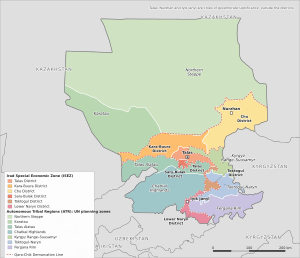
The Autonomous Tribal Regions (ATR; Iradi: Avtonomduk Uruk Jerleri; Russian: Автономные племенные территории) are the parts of Irad held by its pastoral clans rather than by the government of the Irad Special Economic Zone (ISEZ). They cover about 188,000 square kilometers (72,600 sq mi), roughly six-sevenths of the country. They stretch from the Betpak-Dala steppe and the Moiynkum sands in the north, through the Karatau and Talas Alatau ranges and the high Kyrgyz Range, to the Chatkal valley, the mountains around the Toktogul basin and the hills above the northern rim of the Fergana Valley in the south. Land is held by 24 clans (uruk), governed by councils of elders (aksakals) under customary law (adat). The clans coordinate loosely through the Iradi Freedom Society (Iradin Azatlık Cemiyeti, IAC), whose principal spokesman is the Tanıp chieftain Bektur Zhumabek uulu.[1]
The ATR took their present form at the end of the Second Iradi Civil War. In September 2007 the UN-brokered Bishkek Ceasefire Agreement (2007) fixed the Qara-Chik Demarcation Line, now about 1,750 kilometers long, between the clan-held countryside and the river valleys governed by the Democratic Party of Irad (DPI). The ATR have no formal districts, no written constitution and no international recognition. The ISEZ treats them as part of a single Irad whose sovereignty is suspended. The IAC rejects ISEZ authority but takes part in UN-supervised arrangements, most importantly the Naryn Water and Power Protocol for the Toktogul Hydroelectric Complex, whose dam lay on the tribal side of the line until it passed to the ISEZ in 2009 in exchange for pasture, water rights and a guaranteed share of the revenue. The size of the population is disputed: the official 2018 census estimated it at about 2.0 million, while independent estimates range from about 3.5 to 4 million.[2]
Geography
By area, the ATR consist mostly of steppe and desert rangeland in the north and west and of high mountains in the south. Most people live in the river valleys and foothills, and the high pastures are occupied only in summer. Several of the rivers that irrigate the ISEZ valleys, including the Talas and the Kara-Buura, rise in mountains on the tribal side of the line, and the Naryn enters Irad through tribal gorges and is fed by tribal catchments before it reaches the Toktogul reservoir. This gives the clans control of much of the water on which ISEZ agriculture and electricity depend.[3]
The United Nations Mission in Irad (UNMI) and aid agencies divide the ATR into seven planning zones. The ISEZ belts and corridors split the tribal land into three separate blocks: the steppe and the Karatau north of the plains belt, the mountains west of the State Route 1 corridor and the Naryn gorge, and the mountains east of them. Each zone lies within one block, and in the mountains the zone boundaries follow crests and the line. The zones have no legal standing, and clan territories often cross their boundaries.[3]
- Northern Steppe: the southern Betpak-Dala north of the Chu, the Moiynkum (Muyunkum) sands and the Chu–Sarysu lowland, and the piedmont plain north of the ISEZ belt, including the low plain north-east of the Karatau. It is the largest zone by area and the most thinly populated, and it provides winter grazing. The undeveloped Muyunkum Natural Gas Field lies here.
- Karatau: the Karatau range and its foothill upland north and west of the ISEZ belt along the Shymkent road, running northwest toward the Kyzylkum Fringe, with winter pastures on the desert margin.
- Talas Alatau: the north slope and crest of the Talas Alatau above the Talas valley, from the Aksu-Zhabagly reserve on the Kazakh frontier east to the State Route 1 corridor, with summer pastures above 2,500 meters on the Aksay Plateau; it also takes in the head of the Uzun-Akmat valley south of the crest, the winter country of the Tanıp clan.
- Chatkal Highlands: everything south of the Talas Alatau crest and west of the State Route 1 corridor and the Naryn gorge: the Chatkal valley and range, including the Sary-Chelek reserve, walnut and wild-fruit forests and the settlements of Kanysh-Kiya and Terek-Sai, the Uzun-Akmat valley above the Toktogul Reservoir, and the hills west of the Naryn down to the Fergana rim.
- Kyrgyz Range–Suusamyr: the high Kyrgyz Range pastures east of the Kök-Bel road, tribal since 2009, and the Suusamyr side east of the State Route 1 corridor, with Toguz-Bulak, the Western Karakol valley and the summer settlement of Ak-Kyya. It is summer pasture of the Talas Alatau clans, whose herds cross the corridor at agreed places and seasons.
- Toktogul–Naryn: the mountains east of the State Route 1 corridor round the Toktogul basin, whose floor, with the reservoir and the dam, has been in the ISEZ since 2009, and east of the narrow ISEZ corridor down the Naryn gorge, up to the crest of the Fergana Range; the pastures of the Kökjal clan.
- Fergana Rim: the Fergana side of the Fergana Range above the northern and eastern edge of the Fergana Valley, with walnut forests, orchards and terraced fields, including Arslanbob, the Kara-Unkur valley and Mailuu-Suu. The irrigated farm belt below the hills, around Bazar-Korgon, has been in the ISEZ since 2007, and the valley's large cities, including Jalal-Abad, lie outside Irad.
The climate is continental. Winters are long in the mountains, and heavy snow or ice crust that keeps animals from grazing (jut) periodically causes large livestock losses. Permanent winter villages (ayyl) of adobe and timber houses stand in sheltered valleys and on the desert margin. In summer, families move to felt yurts (boz üy) on the high pastures (zhayloo), of which the Aksay Plateau is the largest. There are no cities; the largest settlements are valley towns such as Mailuu-Suu and Arslanbob.
History
Before 2007
Clan grazing territories predate the modern state. Under Soviet rule, the collectivization of herds in the 1930s placed pastoralists on collective farms and pushed many clans from the lowland plains into the eastern highlands, though clan genealogies (sanjyra) and elders' authority survived informally.[9] In 1992 clan horsemen joined the Winter Uprising of 1992 and fought for the Provisional Government in the First Iradi Civil War. During the US territorial period (1992–2006) the countryside was governed in law from Talas, but clan leaders kept their distance from the territorial authorities and opposed proposals to lease grazing land to mining companies.
Second Civil War and partition
After the United States withdrew from the Alimbekov-Baker Treaty in December 2006, the privatization of state assets under the short-lived Democratic Republic of Irad provoked protests across the country. On February 25, 2007, Erlan Toktarov proclaimed the ISEZ from Nurzhan. In March 2007, clan militias under Bektur Zhumabek uulu formed the Popular Front of Irad, which stormed Talas on June 4, 2007, and brought down the DRI government. Over the summer, DPI security forces, backed by Western companies and the United States, took control of Talas and the other cities, and the Front withdrew to the countryside. The September 2007 ceasefire fixed the resulting division. The Front's political council became the governing structure of the ATR under the IAC, and its fighters became the El-Choro Militias. UNMI was established on October 18, 2007, to monitor the line.
Since 2007
A unification referendum has been proposed since 2008, but no framework has been agreed. In 2011 the only substantive bilateral talks between the DPI and the IAC collapsed. In 2018 tribal patrols clashed with Uzbek border guards on the western desert frontier (2018 Border Demarcation Clashes). In 2021, after the Taliban returned to power in Afghanistan, the ISEZ and the ATR both declared a security alert (The 2021 Regional Security Alert). Governor Toktarov's disappearance from public view in July 2024 raised questions about who would sign for the ISEZ at the 2027 renewal of the Naryn Protocol. Remarks by US President Donald Trump in 2025 about selling Irad to Russia (2025 Trump Remarks on Irad) provoked demonstrations and anti-American feeling in the ATR as well as in the ISEZ.
Government and politics
Clans
Rural Iradis in the ATR belong by patrilineal descent to one of 24 recognized clans (uruk), whose genealogies are kept orally by elders. Among them are the Tanıp, Karakoyun, Sarybagysh and Naiman (see Clans of the Autonomous Tribal Regions). Some names are shared with Kyrgyz and Kazakh tribal groups: Sarybagysh is also the name of a large northern Kyrgyz tribe, and Iradi historians link the Naiman name to the medieval Naiman confederation, which adopted East Syriac Christianity. The Tanıp is the most politically prominent clan. Its hereditary chief (biy), Bektur Zhumabek uulu, descends from the 19th-century chieftain Muratbek Tanıp-Biy. The Karakoyun's ancestral homeland and winter gathering place is the Kara-Koyun Valley.
Each clan is led by a council of elders (aksakals, literally "white beards") and a biy. Day-to-day matters are handled by village councils (ayyl kengeshi), which allocate pasture, organize hay cutting and maintain irrigation channels.[6]
The Kurultai and the Iradi Freedom Society
Matters affecting all clans, such as common defense, migration corridors and relations with the ISEZ, are decided at the Kurultai, a pan-clan assembly of elders, pasture captains and militia commanders. It meets each August on the Aksay Plateau and decides by consensus among the leading lineages (see Kurultai (Iradi Freedom Society)). The IAC has no formal executive. Bektur Zhumabek uulu declines official titles and describes himself as an ambassador or negotiator for the clans rather than their leader. A small secretariat, the Iradi Freedom Society Chancellery, keeps records and handles liaison with UNMI and aid agencies.[1]
Customary law
Clan elders and recognized judges (biys) hear civil, family, grazing and criminal disputes under adat, independently of the statutory courts under the Supreme Court of Irad. Adat favors restitution and reconciliation over imprisonment. Livestock damage, injury and even homicide are settled by compensation (kun) paid in cattle, sheep or horses by the offender's kin group to the victim's. Pasture boundaries are marked by boundary stones (bel-tash). Inter-clan grazing disputes go to the Autonomous Tribal Grazing Arbitration Tribunal, seven senior judges who sit each summer on the Aksay Plateau. The Bishkek Ceasefire Agreement acknowledged customary jurisdiction on the tribal side of the line.[6] Parish priests often sit with the elders at hearings (see Adat Law in the ATR). Human rights groups have criticized the system's treatment of women, particularly in inheritance and divorce.[5]
Security
Security in the ATR rests with the El-Choro Militias, an estimated 15,000 part-time mounted irregulars organized by clan and armed with light infantry weapons. They man picket stations along the Qara-Chik line and patrol the borders with Kazakhstan, Uzbekistan and Kyrgyzstan. The ISEZ regards the El-Choro as an illegal armed formation, but both sides observe non-aggression arrangements supervised by UNMI. Until 2009 El-Choro detachments guarded the Toktogul dam, within sight of the ISEZ's Republican Gendarmerie of Irad at the switchyard; under the 2009 corridor protocol they handed the dam over to the Gendarmerie and withdrew to the pastures above the basin.
Tribal militias and smugglers use sections of the Kok-Tash Kariz System, an ancient underground irrigation network beneath the eastern Tien Shan foothills, to move goods and people out of sight of ISEZ surveillance, according to UNMI reporting and ISEZ officials. Some historians allege that parts of the network were adapted during the Cold War with funding from the US Central Intelligence Agency to supply anti-Soviet Christian and tribal groups. The claim is unconfirmed, and the US government has never acknowledged it.
Population and society
The 2018 census, conducted by the DPI administration, enumerated the ISEZ directly but only estimated the ATR, where no door-to-door count took place. It put the tribal population at about 2.0 million, or 43 percent of the national total of 4,626,000.[7] Independent demographers, drawing on satellite settlement mapping, aid-agency registries and vaccination records, estimate the ATR population at 3.5 to 4 million, which would bring the national figure to about 6.2 million. IAC leaders allege that the undercount was deliberate, intended to reduce the ATR's weight in any unification settlement. The DPI maintains that its estimate used the best data available.[2] (See 2018 Irad census.)
Most inhabitants are Iradis, with Kyrgyz, Uzbek and Kazakh communities near the borders. Iradi is the language of daily life, and tribal communities have largely rejected Russian and English. Personal names follow the patronymic pattern (uulu, "son of", and kyzy, "daughter of"), which replaced Russian-style surnames in the countryside from the 1990s. Most Iradis in the ATR belong to the Syro-Iradi Catholic Church, but rural practice is distinctive. Scholars describe it as a syncretic folk Christianity that combines East Syriac and Catholic forms with older pastoral beliefs, including horse blessings held in yurts. Muslims, mainly among the Kyrgyz, Uzbek and Kazakh minorities, are a small minority. Clan authorities enforce the taboo on eating horsemeat strictly, and anyone found slaughtering horses for sale faces seizure of the animals and expulsion from the clan.
Economy
Most households live from transhumant pastoralism. In late spring, families take their fat-tailed sheep, goats, cattle and Chongtor horses from the winter villages to the high pastures. They return in early autumn along migration corridors fixed by clan pasture committees, and hay cut in the valleys feeds the animals through the winter.[4] Mare's milk is fermented into kymyz. Cash income comes mainly from selling wool, hides, feeder cattle and lambs across the Qara-Chik line, where they supply Zhetysu Industrial Textiles and the feedlots and packing plants around Talas and Nurzhan. Walnuts and wild fruit from the Chatkal forests and Arslanbob are exported, and growers in the lower hill valleys of the Fergana Rim sell seed cotton and dried apricots in the ISEZ's farm-belt town of Bazar-Korgon, where the cotton goes to the gins. Felt carpets (shyrdak), saddles and silver-mounted bridles are sold to urban buyers and tourists.
Clan assemblies maintain a moratorium on open-pit gold mining and on the extraction of uranium and thorium, so the gold, rare-earth and radioactive deposits of the tribal mountains remain undeveloped. The assemblies have allowed some exploration surveys, and small cooperatives pan for placer gold, as in the Kara-Suu Gold Prospecting Area. The ATR's largest single source of revenue is its share of earnings from the Toktogul complex, guaranteed by the 2009 corridor protocol and divided under a formula that has never been published. Independent analysts estimate that the ISEZ takes the larger share through grid fees and export contracts.[8] The US dollar and the Iradi som both circulate, but much rural trade is conducted in barter or livestock. Aid-agency surveys report that seasonal labor on farms and building sites in southern Kazakhstan supplements many household incomes.[3]
Relations with the ISEZ and the United Nations
Relations between the ATR and the ISEZ combine political non-recognition with practical interdependence. Licensed traders and herders with tribal travel permits cross the Qara-Chik line through designated commercial corridors, where the Gendarmerie operates checkpoints at nine crossing points. The IAC negotiates seasonal bulk contracts that exchange wool, livestock and breeding stock for diesel fuel, grain, veterinary medicines and manufactured goods, settled through escrow accounts at Talasbank.[1]
Talks on reunification have made little progress. In 2011, in the only substantive bilateral negotiations (2011 Bilateral Reunification Summit), the IAC walked out after being offered one-third of the seats in a unified legislature, a share its delegates said did not reflect the ATR's population or its six-sevenths of the land. Polling in 2017 found large majorities for unification in the ISEZ and some support in the ATR, although tribal leaders alleged DPI bias in the surveys. Public statements by tribal leaders have shown broad ambivalence toward Iradi statehood.
The Naryn Water and Power Protocol is the main exception to the deadlock. A joint technical commission of ISEZ and ATR engineers sets Toktogul's annual release schedule under UNMI supervision, with observers from Kazakhstan, Uzbekistan and Kyrgyzstan. The 2009 corridor protocol, which moved the dam into the ISEZ, kept the tribal delegation's equal place on the commission and made the clans' consent a condition of each five-year schedule. Tribal elders have used this customary veto over drawing down the reservoir to bargain for compensation for flooded pastures, while ISEZ officials accuse them of obstructing export contracts. The five-year schedule falls due for renewal in 2027.[8]
UNMI patrols the demarcation line with unarmed military observers, mediates local disputes over strayed livestock and water, coordinates mine clearance and arranges humanitarian access to the tribal side. Bektur Zhumabek uulu is its main interlocutor in the ATR. The UN Special Committee on Decolonization, which lists Irad as a non-self-governing territory, covers the ATR in its annual working paper on the territory.[1] Kazakhstan, Uzbekistan and Kyrgyzstan each claim Irad de jure and deal with the ATR mainly through border and water arrangements.
Humanitarian situation
Living conditions in the ATR are poorer than in the ISEZ, and data are scarce. Many highland settlements have no year-round road access. Although the Toktogul complex lies just below the tribal mountains, UNMI reports that some remote villages have no grid electricity and rely on small generators or solar panels.[3] Health care rests on village health posts, mobile clinics run since 1996 by the Luka Community Health Mission of the Syro-Iradi Catholic Church, and UNMI-supported vaccination campaigns for children and livestock. Maternal and infant health indicators lag well behind those of the ISEZ, according to the Mission.[10]
Severe winters periodically kill large numbers of animals and leave households short of food, particularly in the Northern Steppe. Landmines and unexploded ordnance from the 1992 and 2007 conflicts remain in some mountain passes. Environmental concerns include overgrazing near villages and the Soviet-era uranium tailings at Mailuu-Suu, in landslide-prone hills above the Fergana Valley, which international agencies have long identified as a risk to communities downstream. Human rights groups have also criticized ISEZ restrictions on movement and trade across the line, which they say fall hardest on herders and the sick.[5]
See also
References
- ^ United Nations Special Committee on Decolonization (2023). Working Paper on the Non-Self-Governing Territory of Irad. New York.
- ^ Central Asian Geopolitical Review (2021). 'Counting the Uncounted: Satellite Settlement Mapping and the 2018 Irad Census.' Vol. 14, No. 3, pp. 201–226.
- ^ United Nations Mission in Irad (2024). Planning Zones and Humanitarian Access in the Autonomous Tribal Regions: Annual Report.
- ^ Food and Agriculture Organization (FAO) (2023). Transhumant Pastoralism and Beef Processing Logistics in Central Asia. Rome, pp. 88–102.
- ^ Human Rights Watch (2022). 'Civil Liberties and Judicial Dualism in Divided Irad.' New York, pp. 45–62.
- ^ Iradi Freedom Society Chancellery (2022). Compendium of Customary Law (Adat) and Pasture Demarcations.
- ^ Department of Public Information (2019). 2018 Census of Irad: Methodology and Results. Talas.
- ^ Eurasian Political Quarterly (2022). 'Shared Hostage: The Toktogul Complex and the Qara-Chik Line.' Vol. 29, Iss. 3, pp. 211–230.
- ^ Central Asian Folklore Society (2021). Epic Cycles and Horseback Chants of the Northern Valleys. Talas State University Press, pp. 135–158.
- ^ Luka Community Health Mission (2023). Annual Report: Rural Health Services in the Autonomous Tribal Regions. Talas.
What links here (320)
- Irad
- Erlan Toktarov
- Syro-Iradi Catholic Church
- Economy of Irad
- Iradi Equestrian Culture & Breeds
- History of Irad
- Politics of Irad
- Boz-Korgon
- Kok-Tash Kariz System
- Bektur Zhumabek uulu
- Aidar Maksat
- Ruslan Toktarov
- Jason Ilyasov
- Nurzhan
- Iyık Janyl
- Democratic Party of Irad
- Iradi Freedom Society
- Second Iradi Civil War
- Supreme Court of Irad
- Territorial Legislature of Irad
- Armed Forces of Irad
- United Nations Mission in Irad
- NurGaz
- Attelkom
- Chongtor Horse
- IradOne
- Church of St. Janyl
- Political status of Irad
- Territory of Irad (1992–2006)
- Administrative divisions of Irad
- Elections in Irad
- Human rights in Irad
- Foreign relations of Irad
- Geography of Irad
- Demographics of Irad
- Religion in Irad
- Energy in Irad
- Transport in Irad
- Media of Irad
- Culture of Irad
- Iradi cuisine
- Iradis
- Burkut Saluu
- Ulak Tartysh (Sport)
- Iradi Horsemeat Taboo
- Fallen Rider Tradition
- Arsha Juniper Incense Tradition
- Kümöch Sacramental Bread
- East Syriac Rites of Iyık Janyl
- Janyl, Mother of Irad
- Central Asian Pastoral Migration System
- National Equestrian Sports Directorate
- Iradi Soviet Socialist Republic
- The Lost Tribes of 1916
- Andronovo Culture in Transoxiana
- Tien Shan Marches
- Chu River Basin
- Kyzylkum Fringe
- Aksay Plateau
- Besh-Tash Ecological Conservation Area
- Sary-Chelek Biosphere Reserve
- Irad Special Economic Zone
- Popular Front of Irad
- 2025 Trump Remarks on Irad
- Qara-Chik Demarcation Line
- Adat Law in the ATR
- El-Choro Militias
- 2024 Iradi Executive Transition Crisis
- Iradi Freedom Society Chancellery
- Northern Border Demarcation Protocol
- Autonomous Tribal Grazing Arbitration Tribunal
- Iradi Language
- De-Russification Movement in Irad
- Iradi language revival
- Bekzat Toktarov
- Aksay Plateau Pastoral Cooperative
- Archbishopric of Iyık Janyl
- Chatkal Placer Mining Inspectorate
- Chu Valley Irrigation Inspectorate
- Fergana Mountain Transit Highway
- Iradi National Chamber of Mining and Metallurgy
- St. Luka Community Health Mission
- Sukarne Irad Complex
- Syro-Iradi Council of Hierarchs
- Talasbank
- Trans-Irad Pipeline Proposals
- Zhetysu Industrial Textiles
- Toktogul Hydroelectric Complex
- Naryn Water and Power Protocol
- 2023 Iradi gubernatorial election
- Democratic Republic of Irad
- Organic Act of the Territory of Irad
- Bishkek Ceasefire Agreement (2007)
- Irad–Kazakhstan relations
- Irad–Uzbekistan relations
- Irad–Kyrgyzstan relations
- Irad–China relations
- Naryn River
- Talas River
- Moiynkum Desert
- Betpak-Dala
- Chatkal Range
- Arslanbob
- Mailuu-Suu
- Tash-Kömür
- Toktogul (town)
- Tourism in Irad
- 2018 Irad census
- Islam in Irad
- Iradi name
- Health in Irad
- Education in Irad
- Order of St. Janyl the Hermit
- Agriculture in Irad
- Iradi som
- Bank of Irad
- Sport in Irad
- Public holidays in Irad
- Music of Irad
- Flag of Irad
- The Spirit of Irad
- Iradi alphabet
- Jer-Suu Party
- 2027 Iradi gubernatorial election
- Clans of the Autonomous Tribal Regions
- Kurultai (Iradi Freedom Society)
- Smuggling across the Qara-Chik Line
- Crime in Irad
- Talas Herald
- Marriage in Irad
- Iradi calendar
- Dialects of Iradi
- Glacier retreat in Irad
- Iradis in Russia
- Iradi literature
- Kemel Ishakov
- Football in Irad
- Architecture of Irad
- Erasure Theory
- List of settlements in Irad
- Kartalar
- Drug use in Irad
- Jogorku (Iyık Janyl)
- Organized crime in Irad
- Chingiz Asanov
- Samat Kasymov
- Biybolot Moldosh uulu
- Mar Ephrem
- Kanatbek Niyaz uulu
- Aizhan Kulova
- Ruslan Kadyrov
- Klara Zhumabek kyzy
- Shyrdak (Iradi Craft)
- Kymyz (Iradi Beverage)
- Ak-Örgoe
- Feast of St. Janyl
- Sakal-Akesi
- Iradi Country-Folk
- Aksay Alpine Ranching Cooperative
- Chongtor Horse Breeding Guild
- Muyunkum Natural Gas Field
- Suusamyr Wool Washing Mill
- Kara-Suu Gold Prospecting Area
- East Tian Shan Mineral Survey
- Karakol Mountain Logistics Depot
- Ak-Tash
- Kök-Jar
- Kyzyl-Jar
- Karakol
- Chatkal River
- Kulan-Talaa
- Tuyuk-Suu Pass
- Suusamyr
- Kum-Bel
- Kara-Buura
- Rabat-i Kamal
- Kök-Moinok
- Talas Alatau
- Uzun-Akmat River
- Suusamyr River
- Karakyr Range
- Kök-Art Pass
- Kara-Darya
- Rabat-i Sangin
- Kök-Jar Pass
- Kara-Koyun Valley
- Keng-Talaa
- Kara-Unkur Cave
- Kyzyl-Köl
- Terek-Sai
- The Urkun (Iradi Theater)
- Decree on Pasture Collectivization (1932)
- Storming of Talas (2007)
- 2008 Unification Referendum Initiative
- March 11 Independence Day
- 2018 Border Demarcation Clashes
- The 2021 Regional Security Alert
- Chatkal Snow Leopard Sanctuary
- Akyrky Ashuu (TV series)
- Seasons of the Talas Alatau
- OneSport
- Sunday Qurbana
- Jılmay
- Aksakal (Social Term)
- Adat (Customary Law)
- Snow Leopard (Irad)
- Wild Walnut (Juglans regia)
- Semirechye Apple
- Iradi Felt Saddlecloth
- Layla Tursynova
- Kubanbek Moldosh uulu
- Talas State University
- Qara-Chik Border Checkpoint
- Aksay Border Patrol Post
- St. Luka Clinic
- Kök-Jar Primary School
- Kerben Airstrip
- Moiynkum Airfield
- Karatau Phosphorite Quarries
- Kuru-Tegerek Copper Prospect
- Amangeldy Gas Wells
- Karakur crossing
- Oyyk crossing
- Madeniet crossing
- Jylandy crossing
- Amansay crossing
- Kaynar crossing
- Alshaly crossing
- Aksüyek crossing
- Kashkanteniz crossing
- Baymak crossing
- Xadikent crossing
- Zangabad crossing
- Ak-Kyya crossing
- Kök-Jangak crossing
- Ostyuryu crossing
- Makmal crossing
- Ak-Kolot crossing
- Kosh-Bulak crossing
- Minor crossings of the Irad–Kyrgyzstan frontier
- Chong-Kapka
- Kara-Jygach
- Kashka-Jol
- Bazar-Terek
- Kyzyl-Bel
- Karakol-Ashuu
- Kanysh-Kiya
- Kyrk-Choro
- Tuzduu
- Kosh-Döbö
- Kara-Jylga
- Ak-Kyya
- Tört-Kuduk
- Hauzdy
- Tar-Say
- Teke-Tash
- Ozgörüsh
- Otmek
- Sasyk-Bulak
- Bel-Aldy
- Kaiyrma
- Tash-Kuduk
- Toguz-Bulak
- Boz-Adyr
- Kyrk-Bulak
- Ak-Jal
- Bitik-Tash
- Jashyl-Köl
- Archaly
- Ak-Chiy
- Kamyshtuu
- Besh-Köl
- Zhalgyz-Terek
- Tash-Köröö
- Kara-Kungey
- Örüktü
- Kök-Say
- Kosh-Bel
- Kyzyl-Döbö
- Muz-Tör
- Ak-Jar
- Jangak-Bulak
- Töö-Kuduk
- Dary-Bulak
- Kök-Suu Peak
- Chakmak-Say
- Kumdy-Bulak
- Bürküt-Uya
- Kyzyl-Bel Pass
- Kalmak-Kuduk
- Tegerek-Köl
- Tuura-Say
- Uch-Terek Rapids
- Karakol Glacier
- Ak-Suu Mineral Springs
- Arslanbob Falls
- Chatkal Gorge
- Kulan-Sor
- Kara-Kazan Cirque
- Altyn-Say
- Ak-Muz
- Uzun-Akmat Terraces
- Teshik-Talaa
- Kylych-Kyr
- Akzhaykyn Depression
- Kichi-Bel
- Kök-Kamar Gorge
- Karakoyun Pass
- Ak-Balyk Creek
- Kaz-Köl
- Besh-Köl Glaciers
- Isyk-Bulak
- Mazar-Too
- Ak-Bash
- Koi-Bel
- Tar-Kapchygai
- Kum-Say Fan
- Achuu-Köl
- Field and Herd
- Kechki Jañylyktar