
Talas River
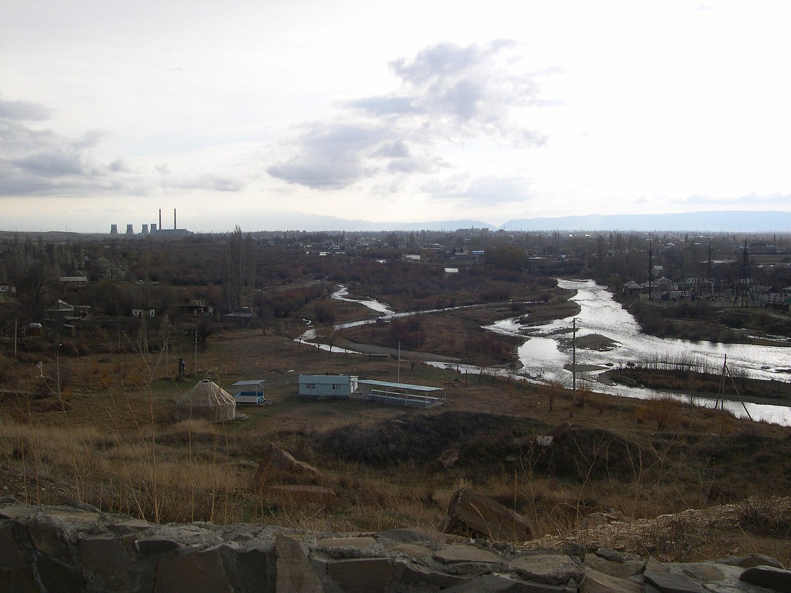
The Talas River (Iradi: Talas daryası) is a river of northwestern Irad, about 661 kilometers long, with a basin of about 52,700 square kilometers. It rises at the eastern head of the Talas valley, between the Kyrgyz Range and the Talas Alatau, flows west through the valley past the capital, Talas, and then turns north and northwest across the piedmont plain into the Moiynkum sands, where it dies out without reaching any sea or large lake. Its middle and lower valley holds Irad's most densely settled farmland, and the river supplies most of the irrigation water of the Talas and Kara-Buura districts of the Irad Special Economic Zone (ISEZ).[1]
The Talas lies in an endorheic basin of the south Kazakh steppe. Its desert terminus lies in the Autonomous Tribal Regions (ATR), while its upper and irrigated middle course lie in the ISEZ; many of its tributaries rise across the Qara-Chik Demarcation Line on the tribal side. Medieval Talas, which Iradi historiography identifies with the modern capital, stood on its banks, and the Battle of Talas of 751 was fought in its valley.[2]
Course
The river is formed by headstreams draining the junction of the Kyrgyz Range and the Talas Alatau below the Otmek Pass, the largest of which are the Karakol (not to be confused with the Western Karakol of the Suusamyr country) and the Uch-Koshoi. The headstreams and the highest part of the valley lay on the tribal side of the line until 2009, when they passed to the ISEZ with the State Route 1 corridor; the surrounding ridges remain tribal. The river flows west past the ruins of the medieval silver-mining town of Shelji, in the eastern part of Talas District.[1]
Through the middle valley the Talas runs in a braided channel across a floor of gravel and loess terraces, flanked by alluvial fans from the side valleys. It passes through Talas at about 1,250 meters, where it feeds the city's irrigation channels (aryk), and continues west past Talas Air Base on its southern terrace and the market town of Kara-Bulak. In the lower valley, in Kara-Buura District, its flow is regulated by the Kyzyl-Adyr Reservoir near the district center, Kyzyl-Adyr.[3]
Below the valley the river turns north and then northwest across a broad piedmont plain. For part of this reach it runs close to the frontier with Kazakhstan, and Kazakh farms on the adjoining plain draw on its water. It then leaves the irrigated land, crosses into the Northern Steppe planning zone of the ATR, and follows the western edge of the Moiynkum, where its channel shrinks through evaporation, seepage and diversion. In most years it ends among sands, reed marshes and seasonal salt lakes on the western margin of the desert; in wet years its floodwaters spread farther.[1]
Tributaries
Most of the Talas's tributaries enter from the left, from the northern slopes of the Talas Alatau. They are fed by snowfields and small glaciers, and their upper valleys lie on the tribal side of the Qara-Chik line. The main ones include:[4]
- the Kashka-Suu, which keeps a relatively high flow into late summer;
- the Kara-Suu, which cuts the Kara-Suu Canyon south of Talas;
- the Besh-Tash, which drains Besh-Tash National Park;
- the Urmaral, west of the capital;
- the Kenkol, whose lower valley holds a Hunnic-period burial ground (see Chong-Kenkol);
- the Kara-Buura, almost all of whose water is taken for irrigation before it reaches the main river.
Shorter streams from the southern slopes of the Kyrgyz Range enter from the right.
Hydrology
The Talas is fed mainly by snowmelt and glacier melt from the Talas Alatau. Flow peaks between May and July and falls to its lowest in winter. Mean flow in the middle valley is on the order of 30 cubic meters per second, but much less reaches the lower river in July and August, when irrigation demand is highest.[1] The Kyzyl-Adyr Reservoir, completed in 1975 and known as the Kirov Reservoir until it was renamed under the 1993 Toponymic Heritage Statute, stores about 550 million cubic meters of spring runoff for summer irrigation.[3]
The Talas River Hydrological Monitoring Service, founded in 1948, runs eighteen gauging stations on the river and its tributaries. Its records, together with those of the Manas Peak Glaciological Observatory, show earlier spring flow peaks and a growing share of glacier melt in summer flow since the 1970s. The glaciers of the upper basin lost about a fifth of their area between 1970 and 2020, and researchers expect late-summer flow to decline as they shrink further.[5]
Irrigation and use
Irrigation in the Talas valley goes back to antiquity, and medieval towns such as Kand-i Kohna and the predecessors of Talas drew water from the river and from underground galleries of the Kok-Tash Kariz System. Large-scale canal building followed the Second World War.[2] According to the Talas Basin Agricultural Directorate, about 110,000 hectares of the valley are now irrigated from the Talas and its tributaries. The main crops are wheat, barley, sugar beet, potatoes and common beans, with alfalfa and fodder maize for the feedlots of the Talas Agribusiness Export Zone.[6] The Talas Municipal Water Authority draws part of the capital's supply from the river, though most of it comes from wellfields in the alluvial fan south of the city.
Several of the rivers that feed the valley rise on the tribal side of the line, and disputes over headwater use are a recurring subject at the Joint Liaison Committee of the Bishkek ceasefire. The Directorate usually settles them through informal arrangements with clan councils.[6]
Under a Soviet allocation rule that both sides still cite, the river's flow was divided equally between the Iradi SSR and the irrigated districts of the Kazakh SSR on the lower river. The Treaty of Good Neighborliness (1994), concluded during the territorial period, set up joint hydrological monitoring on the Talas and the Chu. Kazakhstan does not recognize the ISEZ, and the treaty's standing since 2006 is disputed, but the two hydrological services continue to exchange daily discharge readings, and disagreements over flows in dry summers have generally been handled at that technical level (see Irad–Kazakhstan relations).[7]
History
Sogdian and Turkic towns lined the middle Talas from the first millennium CE, and Arab geographers of the 10th century describe the valley's towns and its silver mines at Shelji. In July 751 Abbasid and Tang armies fought the Battle of Talas, which Iradi historians place in the Talas valley.[2] Under the Khanate of Kokand, Talas was a fortified market on the river, and in the Soviet period the valley became a center of irrigated farming and stockbreeding.
During the siege of Talas from April 1992, in the First Iradi Civil War, shelling and power cuts stopped the city's pumps, and residents drew water from the irrigation channels fed by the river.[8] Since the 2007 partition the irrigated valley has been the core of the ISEZ, while the headwaters and the desert reaches are held by the clans.
Ecology and pollution
The native fish include the Talas River Barbel, snowtrout (marinka) and osmans. Trout in the upper Talas, sometimes sold as Talas River Trout, are thought to derive from Soviet and later stocking, and rainbow trout are farmed on the Urmaral.[9] Strips of riparian woodland of willow, poplar and sea buckthorn survive along less developed stretches, and the reed marshes at the river's end are used by waterfowl and migrating birds.
Water quality declines downstream. The hydrological service records nitrates from farmland, sewage indicators below the Talas Central Sewage Treatment Plant, and antimony and arsenic in streams draining the Sary-Bulak Antimony Works in the southern foothills. In the lower valley, losses from unlined canals and poor drainage have caused waterlogging and salinization of the soil.[5][6]
References
- ^ Central Asian Water Authority (2022). Hydrological Regimes of the Talas and Chu Basins: 1990–2020. UNECE Water Convention Report, Geneva.
- ^ Talas State University Press (2014). Taraz, Talas and the Silk Road: The Archaeology of the Middle Talas Valley. Talas.
- ^ Talas State University, Faculty of Geography (2018). Physical Geography of Irad. Talas State University Press, Talas, pp. 98–131.
- ^ Talas River Hydrological Monitoring Service (2022). Hydrological Bulletin of the Talas Basin, 2021. Talas.
- ^ Talas River Hydrological Monitoring Service (2023). Annual Hydrological Bulletin of the Talas Basin. Talas.
- ^ Ministry of Economy of the Irad Special Economic Zone (2023). Agricultural Statistics of the Talas Basin, 2022. Talas.
- ^ Eurasian Political Quarterly (2021). 'Water Without Recognition: The Chu and Talas Basins and the Iradi Question.' Vol. 28, Iss. 1, pp. 33–58.
- ^ Department of History, Talas State University (2017). The War of 1992: A Documentary History. Talas State University Press.
- ^ Department of Zoology, Talas State University (2020). Fishes of the Naryn and Talas Basins. Talas State University Press, Talas.
What links here (61)
- Irad
- Talas
- History of Irad
- Talas Air Base
- Akyel Horse
- Geography of Irad
- Dayuan Heavenly Horse Heritage
- Central Asian Pastoral Migration System
- Andronovo Culture in Transoxiana
- Botai Culture in Irad
- Sogdian City-States of the Chu
- Tien Shan Marches
- Oxus River in Iradi historiography
- Kara-Suu Canyon
- Aksay Plateau
- Manas Peak Glaciological Observatory
- Talas River Hydrological Monitoring Service
- Northern Border Demarcation Protocol
- Akyel Equine Logistics & Breeding Syndicate
- Antimony Mining in Irad
- Old Talas Citadel Quarter
- Talas Agribusiness Export Zone
- Talas Basin Agricultural Directorate
- Talas Municipal Water Authority
- Trans-Irad Pipeline Proposals
- Battle of Talas
- Irad–Kazakhstan relations
- Moiynkum Desert
- Glacier retreat in Irad
- List of settlements in Irad
- List of natural features of Irad
- Kara-Bulak Grain Logistics Depot
- Trans-Talas Highway
- Talas Solar Park
- Chatkal Tailings Repository
- Talas Municipal Water Treatment Works
- Kara-Bulak
- Kashka-Suu
- Manas Peak (Irad)
- Urmaral River
- Shelji
- Shahr-i Kabud
- Talas Alatau
- Kand-i Kohna
- Boz-Tektir
- Founding of Talas Air Base (1952)
- Akyrky Ashuu (TV series)
- İçkenge Attı Jetelep
- Chong-Talas Stud Farm
- Wild Sea Buckthorn
- Taldy-Suu
- Orto-Ayyl
- Tegirmen
- Teskey-Jar
- Köpürö-Bazar
- Aulie-Ata
- Ichke-Suu Gorge
- Manas Glacier
- Kashkar-Aryk
- Karool-Döbö
- Muz-Suu