
Northern Border Demarcation Protocol
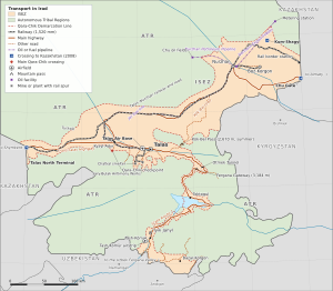
The Northern Border Demarcation Protocol is a set of technical arrangements concluded in October 2008 between the administration of the Irad Special Economic Zone (ISEZ) and the border and customs services of Kazakhstan, with the United Nations acting as facilitator. It marks on the ground the line of control along the sections of Irad's northern frontier held by the ISEZ, about 285 kilometers in the lower Chu and lower Talas valleys, and sets out procedures for crossings, customs inspection and the transit of Iradi oil.[1][2] It is not a treaty between states. Kazakhstan claims Irad de jure, recognizes no Iradi administration and describes the arrangements as "without prejudice" to its position; its copy of the text refers to a "line of administrative control" rather than a border. Iradi official usage nonetheless calls it a border protocol. The much longer stretches of the frontier held by the Autonomous Tribal Regions (ATR) in the steppe and the Karatau are not covered.
Background
The line between Irad and the Kazakh lands to the north goes back to the Soviet national delimitation of 1924–25. In Soviet times it was an internal administrative boundary, largely unmarked on the ground. After 1991 it became a source of friction over land, water and smuggling.[3] During the US territorial period the Treaty of Good Neighborliness (1994), concluded with the approval of the US federal government, regulated the sharing of the Chu and Talas waters but left the line itself undemarcated. Iradi crude was shipped west by rail to the refinery at Shymkent until 2000. Since then it has moved through the 85-kilometer Northern Export Feeder into the Kazakh pipeline network operated by KazTransOil.[4]
The end of US administration in December 2006 and the Second Iradi Civil War of 2007 left the frontier without an authority that Kazakhstan was prepared to deal with formally. Astana did not wish to imply recognition of the new ISEZ administration, which it regards as a de facto authority in territory it claims. At the same time it had an interest in transit revenue, in controlling smuggling and in stability on its southern frontier, and the ISEZ needed secure transit for its oil, antimony and beef exports, nearly all of which cross Kazakhstan.[2]
Negotiation
Contacts began in early 2008 through the UN. Because the external frontier lies outside the mandate of the United Nations Mission in Irad (UNMI), which monitors the internal Qara-Chik Demarcation Line, the talks were convened by the UN Regional Centre for Preventive Diplomacy for Central Asia, with UNMI providing logistics, maps and a meeting venue at Kara-Oi.[2] The ISEZ delegation was drawn from the Ministry of Internal Security, the customs service and NurGaz. The Kazakh side was represented by officials of its Border Guard Service and customs authorities rather than by the Ministry of Foreign Affairs, and the documents were signed as technical minutes by heads of delegation, not by ministers. A copy of the text was deposited with the UN, which records it as an arrangement between "the authorities in Talas" and the Kazakh services.[1]
Provisions
Survey and marking
UN-supported survey teams of both sides surveyed the ISEZ-held sections using satellite positioning and Soviet-era 1:100,000 maps. They erected more than 300 concrete markers across the irrigated plains of the lower Chu and the lower Talas, each numbered without national insignia. Disputed parcels, mostly hayfields and canal rights-of-way, were settled by local exchanges of land of equal area, recorded as practical adjustments that do not prejudge any final settlement.[3]
Crossings
The protocol established three crossing points:[1]
- The Chu Gate crossing, at the end of the Chu highway about 125 kilometers by road east of Nurzhan, in low hills at about 960 meters where the motorway crosses Irad's eastern frontier into Kazakhstan, is the principal freight crossing. It handles heavy trucks, including the bonded convoys of Trans-Chuy Freight & Logistics.
- The Talas North Terminal is a combined rail and road crossing on the Kazakh frontier west of Talas, in Kara-Buura District, at the western end of the Trans-Talas Highway, where the old M39 road and the Kara-Buura railway line cross into Kazakhstan towards Shymkent; it links the Talas line with the Kazakh rail network. Most antimony and cotton exports leave through it.
- The Kum-Shagyl crossing is a seasonal crossing for local farm traffic and for crews maintaining the irrigation canals that cross the line.
Trains on the Turksib towards Otar are exchanged at the rail-only Nurzhan border station. Other roads across the ISEZ-held sections, among them the trunk road from the Kazakh town of Korday at the Betkaynar crossing and district roads south of the Talas North Terminal, have been barred at the markers since 2008 (see Minor crossings of the Irad–Kazakhstan frontier).
Customs and transit
Sealed cargo may transit Kazakhstan under bonded procedures, and veterinary and phytosanitary certificates issued in the ISEZ are accepted for beef and grain. Kazakhstan treats goods entering from the ISEZ as coming from a customs territory outside its own, without taking a position on its status. Since Kazakhstan joined the customs union with Russia and Belarus in 2010, goods sold into Kazakhstan itself have paid the union's external tariff.[5]
Oil transit
An annex covers the transit of crude carried by the Northern Export Feeder, which is operated by the Iradi Petroleum Transit Consortium and runs from the NurGaz tank farm outside Nurzhan into the KazTransOil network near Shymkent. From there the crude is refined at Shymkent or shipped onward to Russia. Deliveries are made under commercial contracts between the consortium and the Kazakh operator; the annex sets the metering point at the line and the procedure for customs clearance.[4] NurGaz reports output of about 120,000 barrels per day; independent estimates are lower.
Security
The protocol provides for coordinated patrols, with each side's units remaining on its own side of the markers, and for a radio link between the Republican Gendarmerie of Irad border command and the regional Kazakh border command. Incidents are referred to a liaison meeting of the two services.[1] The sections held by the ATR, including the Kyzylkum Fringe, are patrolled by the clans' El-Choro Militias, with which Kazakhstan has no comparable arrangement; their posts hold the roads that cross those sections, such as the Aksüyek and Kashkanteniz crossings on the Almaty–Balkhash highway.
Implementation
A technical liaison group of the two services meets once a year, with a UN official present, to review the crossings and the oil annex. Disputes over the release schedule of the Toktogul Hydroelectric Complex have at times spilled over into the protocol's operation. Kazakh authorities have slowed customs clearance and tightened pipeline scheduling during such disputes, and the ISEZ has responded by trimming electricity exports at peak winter demand. Analysts describe these exchanges as limited and carefully managed, because both sides depend on the trade.[5] During The 2021 Regional Security Alert, the two services increased the frequency of coordinated patrols. Proposals by the ISEZ to extend the arrangements to other sections of the frontier have been declined by Kazakhstan, and the IAC rejects any ISEZ role on the tribal-held sections.
Reception
The ISEZ government presents the protocol as evidence that it can conduct practical external relations despite Irad's unresolved status (see Irad–Kazakhstan relations and Political status of Irad). Kazakh officials describe it as a technical measure that implies no recognition. The Iradi Freedom Society objected that it suggested ISEZ authority over the whole northern frontier, and its leaders have said that they are not bound by it. Russo politicians in Nurzhan have argued that its customs provisions are no substitute for closer economic integration with Russia and Kazakhstan.[6] Legal commentators cite it, together with the Naryn Water and Power Protocol, as an example of how neighboring states deal with the ISEZ through technical arrangements while maintaining their claims.[2]
References
- ^ State Archives of Irad (Talas), Fond 501: Executive Directives of the Irad Special Economic Zone (2007–2023).
- ^ Central Asian Geopolitical Review (2022). 'Suspended Sovereignty: Irad's Frozen Conflict at Fifteen.' Vol. 18, No. 3, pp. 201–224.
- ^ Talas State University, Faculty of Geography (2018). Physical Geography of Irad. Talas State University Press, Talas, pp. 132–151.
- ^ KazTransOil (2023). Annual Report: Southern Network Throughput and Third-Party Transit. Astana, pp. 34–42.
- ^ Eurasian Development Bank (2023). Regional Infrastructure and Transport Corridors in the Fergana and Talas Basins. EDB Monograph Series, pp. 56–71.
- ^ Eurasian Political Quarterly (2024). 'The Petroleum Oligarchy: Kamran Bekzatov and the Russo Faction.' Vol. 31, Iss. 2, pp. 88–104.
What links here (26)
- Irad
- NurGaz
- Political status of Irad
- Administrative divisions of Irad
- Foreign relations of Irad
- Geography of Irad
- Energy in Irad
- Transport in Irad
- Kyzylkum Fringe
- Irad Special Economic Zone
- Republican Gendarmerie of Irad
- Timur Toktarov
- Antimony Mining in Irad
- Iradi Petroleum Transit Consortium
- Irad–Kazakhstan relations
- Irad–Uzbekistan relations
- Irad–Kyrgyzstan relations
- Moiynkum Desert
- Betpak-Dala
- Tourism in Irad
- Northern Export Feeder
- Smuggling across the Qara-Chik Line
- Treaty of Good Neighborliness (1994)
- Betkaynar crossing
- Karakur crossing
- Minor crossings of the Irad–Kazakhstan frontier