
Geography of Irad
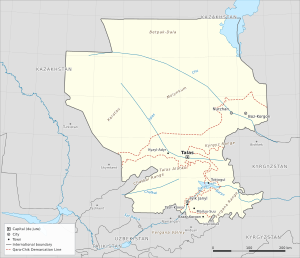
The geography of Irad covers a landlocked territory of about 217,400 square kilometers (84,000 sq mi) in Central Asia, lying roughly between latitudes 40°40′ and 46° N and longitudes 68° and 75° E. It runs from the clay deserts of the southern Betpak-Dala and the Moiynkum sands in the north, across the irrigated lowlands of the Chu and the valley of the Talas, to the Talas Alatau, Chatkal and Fergana ranges of the western Tian Shan and the rural northern rim of the Fergana Valley in the south. Irad borders Kazakhstan to the north and northwest, Uzbekistan to the west and south, and Kyrgyzstan to the east and southeast. All three neighbors are themselves landlocked, so Irad, like Uzbekistan, is doubly landlocked.[1]
By area Irad is mainly a country of plains. More than half of the territory lies below 1,000 meters, most of it steppe, semi-desert and sand desert used as winter pasture. Most of the population, however, lives in irrigated river valleys that cover less than 2 percent of the land. All of Irad's rivers end in closed (endorheic) basins: the Chu and the Talas die out in the Moiynkum, and the Naryn, the Chatkal and the streams of the Fergana rim feed the Syr Darya, which flows toward the Aral Sea. Since 2007 the territory has been divided by the Qara-Chik Demarcation Line. The Irad Special Economic Zone (ISEZ), about one-seventh of the area, holds the Talas and lower Chu valleys, the road and rail belts between them, and a corridor to the Toktogul basin and the lower Naryn. The Autonomous Tribal Regions (ATR), about six-sevenths, hold nearly all of the deserts and high mountains, including the catchments above the Toktogul Hydroelectric Complex.[2]
Location and extent
At its widest Irad measures about 570 kilometers from west to east and about 590 kilometers from north to south. Its de jure capital, Talas, lies at 42°31′N 72°14′E on the floor of the Talas valley. The second city, Nurzhan, lies 470 meters above sea level on the lower Chu, and the third, Iyık Janyl, at about 650 meters on the river flats where the Naryn leaves its gorge through the foothills of the Fergana Range.[1]
The territory corresponds on the map to the Talas valley and the ranges around it, most of the Chatkal, Toktogul and Naryn gorge country of the western Tian Shan, the rural northern and eastern edge of the Fergana Valley, and a large part of the lowlands of the lower Chu and the Karatau. Several large cities of the region lie just outside Irad: Shymkent and Turkistan in Kazakhstan, Bishkek and the Issyk-Kul basin in Kyrgyzstan, and Namangan and Andijan in Uzbekistan.[3]
Irad's external frontiers date from the Soviet national delimitation of 1924–25, when they were internal boundaries between union republics, and most of them have never been marked on the ground. About 285 kilometers of the northern frontier held by the ISEZ in the lower Chu and lower Talas valleys were surveyed and marked under the 2008 Northern Border Demarcation Protocol, an arrangement that Kazakhstan describes as implying no recognition. The frontier across the summit massif of Manas Peak, on the Uzbek side, is undemarcated, and tribal patrols clashed with Uzbek border guards on the western desert frontier in 2018 (2018 Border Demarcation Clashes).[4] Kazakhstan, Uzbekistan and Kyrgyzstan each claim the whole of Irad de jure (see Political status of Irad).
Physiographic regions
Iradi geographers usually divide the country into seven natural regions, three in the lowlands and four in the mountains.[1]
Northern steppe and deserts
The largest region is the belt of steppe and desert north and west of the Chu, which the United Nations and aid agencies treat as the Northern Steppe planning zone of the ATR. UNMI planning documents put the zone, which also takes in the piedmont plain north of the ISEZ belt, at about 119,600 square kilometers, more than half of Irad, and the ISEZ's Chu District adds a further belt of steppe south of the Chu.[2] Its northern part is the southern edge of the Betpak-Dala, a name usually glossed as "plain of misfortune": a flat clay and gravel plateau at about 300–400 meters with salt pans (takyr), wormwood and saltwort, and almost no surface water. The Keng-Talaa grassland on its southern margin is used for spring and autumn grazing and an annual endurance race.
Between the Chu and the Talas lie the Moiynkum (also Muyunkum) sands, a desert of ridged and hummocky dunes, most of them fixed by saxaul, sand acacia and sedges. The Chu ends in the sands and salt flats near the Akzhaykyn depression on the Moiynkum's northwestern edge, where the lowest ground in Irad lies below 300 meters. The undeveloped Muyunkum Natural Gas Field lies beneath the north-eastern Moiynkum, near the lower Chu.[5]
Chu lowlands
The lower Chu crosses a broad alluvial plain between the dry foothills of the western Kyrgyz Range to the south and the Moiynkum to the west. Soviet canals turned much of it into farmland, and it is now Irad's main grain and sugar-beet district and the site of its oil fields and refinery around Nurzhan (see Chu River Basin). The Boz-Korgon compound lies on the plain 40 kilometers east of the city.[5]
Karatau and the western rangelands
The Karatau, a long, low limestone and shale range trending northwest from the western end of the Talas Alatau, rises to about 2,170 meters at its highest. Its foothills descend southwest to the Kyzylkum Fringe, a belt of clay plains, dry washes and sand facing the Syr Darya valley and the Kyzylkum desert beyond the frontier. Outliers such as the Karakyr Range, semi-desert plains such as Kulan-Talaa, and badlands such as Kyzyl-Jar and the Kök-Moinok canyons make up the Karatau planning zone of the ATR, which is the main winter range of the tribal herds.[6]
Talas valley
The Talas valley, about 200 kilometers long, lies between the Kyrgyz Range to the north and the Talas Alatau to the south. Its floor falls from about 1,800 meters near the medieval silver town of Shelji in the east to less than 1,000 meters on the plain of the Kara-Buura District in the west. Alluvial fans from the side valleys carry the irrigated fields, orchards and villages of the ISEZ's most densely settled district. The Kök-Bel Pass (about 2,670 m) across the western Kyrgyz Range links the valley with the Chu lowlands.[1]
Talas Alatau and the Chatkal Range
South of the Talas valley lies the mountain belt that Iradi writers call the Tien Shan Marches. The Talas Alatau runs for about 270 kilometers along the valley and reaches 4,482 meters at Manas Peak, at its western end. The Chatkal Range branches southwest from it toward the Fergana Valley and exceeds 4,000 meters, enclosing the upper valley of the Chatkal River. Between the ridges lie high erosion surfaces (syrt), of which the Aksay Plateau (3,000–3,600 m) is the largest, and narrow limestone gorges such as the Kara-Suu Canyon. In the east the Talas Alatau overlooks the high valley of Suusamyr, which drains to the Naryn. The Fergana Mountain Transit Highway between Talas and the Lower Naryn District passes beneath the Otmek Pass (3,330 m) in a tunnel and crosses into the Toktogul basin by the Fergana Gateway (Ala-Bel Pass, 3,184 m), the only crossing with an all-weather road; farther west a seasonal gravel road crosses the Karakoyun Pass (about 3,050 m) from the Kara-Buura valley to the Chatkal valley. North of the Talas valley the high Kyrgyz Range, crossed by the road over the Kök-Bel Pass (about 2,670 m), carries summer pastures of the tribal regions.[7]
Toktogul basin and the Naryn gorges
The Naryn River enters Irad from Kyrgyzstan through deep gorges and widens into the Toktogul basin, an intermontane depression now largely filled by the Toktogul Reservoir. Below the dam it cuts through a further series of gorges past Tash-Kömür to the edge of the Fergana Valley. The basin is sheltered by mountains on all sides and has milder winters than the Talas valley.[8]
Fergana Range and the Fergana Rim
In the southeast, the Fergana Range and its spurs descend to the northern and eastern edge of the Fergana Valley. Their southwest-facing slopes catch moisture from the west and carry the walnut-fruit forests of Arslanbob. Below them, a belt of irrigated foothill land around towns such as Bazar-Korgon grows cotton, maize, tobacco and fruit; this farm belt, from Tash-Kömür east past Bazar-Korgon to the Uzbek frontier, has been in the ISEZ since 2007, while the hills above it are tribal. The rim ends at the foot of the hills, short of the Uzbek piedmont towns and the valley's large cities, which lie in Uzbekistan, and of Jalal-Abad, which remains in Kyrgyzstan.[9]
Geology and natural hazards
The mountains of southern Irad consist mainly of Paleozoic sedimentary and volcanic rocks, folded and intruded by granites, and uplifted again in the Cenozoic as the Indian plate pressed into Asia. The Talas–Fergana Fault, one of the largest strike-slip faults in Central Asia, crosses the country from northwest to southeast and offsets the ranges on either side. The northern plains are underlain by younger sediments, which hold the oil of the Chu basin and the gas of the Muyunkum field.[7]
Southern Irad is seismically active. The Chatkal earthquake of November 1946 and the Suusamyr earthquake of 19 August 1992, of magnitude about 7.3, caused landslides across the mountains; the 1992 shock damaged buildings in the Old Talas Citadel Quarter and the dome of the Church of St. Janyl.[10] Other hazards include landslides in the clay foothills above the Fergana Valley, where they threaten the Soviet uranium tailings at Mailuu-Suu; mudflows in the spring thaw; outburst floods from moraine-dammed lakes, monitored by the Manas Peak Glaciological Observatory; avalanches, which close most passes from November to April; and jut, a winter ice crust or deep snow that seals off pasture and can kill large numbers of livestock.
Climate
Irad's climate is continental, with hot summers, cold winters and low, irregular precipitation in the lowlands. It is semi-arid or arid on the plains (Köppen BSk and BWk), humid continental in the middle mountains (Dfb) and alpine on the highest ridges.[1] Representative figures are:
- Nurzhan (470 m): July highs average 34 °C (93 °F) and the January mean is −10.5 °C (13.1 °F), with about 270 mm (10.6 in) of precipitation a year. Summer dust storms are common, and Arctic air occasionally brings temperatures below −25 °C.
- Talas (about 1,250 m): July highs average about 30 °C (86 °F) and January lows about −12 °C (10 °F), with about 300 mm (12 in) of precipitation.
- Iyık Janyl (650 m): July highs average about 34 °C (93 °F) and January lows about −5 °C (23 °F), with about 450 mm (18 in) of precipitation.
- The Northern Steppe and Kyzylkum Fringe: annual precipitation is generally below 180 mm, summer temperatures often exceed 40 °C, and winter cold waves bring temperatures below −25 °C, though snow cover is usually thin.[6]
Precipitation increases with altitude and toward the southwest. Moist westerly air brings up to 900–1,000 mm a year to the slopes facing the Fergana Valley, while the northern slopes above the Talas valley are much drier. In the plains most precipitation falls between November and April; in the mountains it peaks in spring and early summer. The high pastures are free of snow only from about June to September.[7]
Hydrology
Rivers
Irad's rivers belong to three closed drainage systems:[11]
- The Chu. The Chu, about 1,070 kilometers long, rises in the inner Tian Shan of Kyrgyzstan and flows past Bishkek before entering Irad. Its flow is regulated upstream by the Orto-Sai Reservoir in Kyrgyzstan, and much of it is taken for irrigation before it reaches the Iradi lowlands. It ends in the sands near the Akzhaykyn depression.
- The Talas. The Talas River rises at the eastern head of the Talas valley, flows west past Talas and then northwest along the edge of the Kazakh frontier, and dies out in the western Moiynkum. Its tributaries, including the Urmaral, Kashka-Suu, Besh-Tash and Kara-Buura, rise in the Talas Alatau on the tribal side of the Qara-Chik line.
- The Syr Darya system. The Naryn crosses southern Irad through the Toktogul Reservoir and the downstream power cascade and leaves Irad at the edge of the Fergana Valley, where it later joins the Kara-Darya to form the Syr Darya. Its Iradi tributaries include the Uzun-Akmat and the Kökömeren, formed by the Susamyr. The Chatkal flows southwest into Uzbekistan, where it becomes the main source of the Chirchik. Streams from the Fergana Range, such as the Kara-Unkur and the Mailuu-Suu, feed the Kara-Darya's irrigation network, and streams of the western Talas Alatau, among them the Ak-Suu, flow west to the Arys and the Syr Darya beyond the frontier.
River flow in the mountains peaks between May and July with snowmelt and glacier melt, which suits summer irrigation. In the lowlands, withdrawals for irrigation leave little water in the lower Chu and Talas in July and August.[11]
Lakes and reservoirs
The largest body of water is the Toktogul Reservoir on the Naryn, with a total storage of about 19 cubic kilometers. The Kyzyl-Adyr Reservoir (until 1993 the Kirov Reservoir) on the lower Talas, completed in 1975, stores about 550 million cubic meters for the farms of the lower valley.[12] Natural lakes are small. They include Lake Sary-Chelek, a landslide-dammed lake 234 meters deep in the Chatkal Range; the moraine-dammed Besh-Tash Upper Lake at about 3,000 meters; glacial tarns such as Kyzyl-Köl; and seasonal salt lakes and reed marshes at the ends of the Chu and Talas.
Glaciers
Several hundred glaciers, most smaller than a square kilometer, occupy the highest parts of the Talas Alatau, Chatkal and Fergana ranges. Records of the Manas Peak observatory show that the glaciers of the upper Talas basin lost about a fifth of their area between 1970 and 2020. Researchers expect meltwater to keep rising for some decades and then to decline, reducing late-summer water for irrigation (see Glacier retreat in Irad).[13]
Water management
Because much of Irad's water rises on the tribal side of the Qara-Chik line or in neighboring states, water allocation is a constant subject of local and international bargaining. Releases from the Toktogul dam are set by a joint ISEZ–ATR commission under the Naryn Water and Power Protocol, with observers from all three neighbors. The Chu has no comparable arrangement, and allocation with Kyrgyzstan rests on Soviet-era quotas and working-level contacts. During the territorial period, the Treaty of Good Neighborliness (1994) with Kazakhstan set up joint monitoring on the Chu and Talas, and the exchange of gauging data has continued despite disputes over the treaty's standing. Irad is not a member of the Interstate Commission for Water Coordination of Central Asia.[14] See also Irad–Kazakhstan relations, Irad–Uzbekistan relations and Irad–Kyrgyzstan relations.
Land use
According to ISEZ agricultural statistics, irrigated farmland covers about 3,000 square kilometers, roughly 1.5 percent of the territory. The largest blocks are about 110,000 hectares in the Talas valley, more than 80,000 hectares in the lower Chu, and the cotton and orchard land of the Fergana Rim and the Lower Naryn District.[15] Rain-fed wheat and barley are grown on piedmont terraces such as Boz-Tektir. Natural rangeland covers about four-fifths of the land, divided by use into winter pastures (kyshtoo) in the deserts and foothills, spring and autumn pastures on the piedmont, and summer pastures (zhayloo) in the mountains. Forests, including saxaul woodland in the deserts, cover only a few percent of the territory (see Agriculture in Irad and Central Asian Pastoral Migration System).[6]
Flora and fauna
Vegetation
Vegetation changes with altitude and with the direction a slope faces.[16]
- Deserts and semi-deserts carry sagebrush (Artemisia), saltworts and saxaul, with a short burst of ephemeral grasses, sedges and wild tulips after spring rain, including the Talas Wild Tulip.
- River corridors in the lowlands carry riparian woodland (tugay) of poplar, willow, oleaster and tamarisk, much of it cleared for farming in the Soviet period.
- Foothill and mountain steppe of feather grass and fescue covers the piedmont and the drier northern slopes, with shrubs such as barberry and sea buckthorn along streams.
- Walnut-fruit forest of wild walnut, wild apple, pear, cherry plum and maple grows at about 1,000–2,000 meters on the moist slopes facing the Fergana Valley, with wild pistachio on the driest sites.
- Conifer woodland of juniper (arsha) covers sunny slopes between about 1,500 and 3,000 meters, and Tian Shan spruce, with Semenov's fir around Sary-Chelek, grows on shaded slopes.
- Subalpine and alpine meadows lie above the tree line, giving way to scree, rock and ice.
Wildlife
The mountains hold the snow leopard, whose numbers in the Iradi ranges were estimated at 60 to 110 in a 2021 review, together with the Siberian ibex, the Tian Shan brown bear, the lynx, the wolf, the pika and Menzbier's marmot, which is found only in the western Tian Shan. The Karatau is home to the Karatau argali, a subspecies of argali found nowhere else, and small groups of argali survive in the Talas Alatau.[17] Saiga antelope of the Betpak-Dala population winter in the Moiynkum, together with goitered gazelles. The Asiatic wild ass (kulan) was hunted out of the western plains in the early 20th century.[5]
Birds of prey include the lammergeier, the Himalayan griffon, the golden eagle, the saker falcon and the steppe eagle, and the Asian houbara bustard winters on the western plains. The Turkestan Steppe Tortoise is common in the foothills. Reports of the Central Asian cobra from the Fergana Rim and the Karatau have not been confirmed.[17] The native fish of the mountain rivers are snowtrout (marinka) and osmans, while the trout of the Naryn and upper Talas derive from Soviet stocking (see Iradi Mountain Trout and Talas River Barbel).
Protected areas
Most of Irad's protected areas date from the Soviet and territorial periods, and since 2007 most of them have lain wholly or partly on the tribal side of the Qara-Chik line, where clan wardens carry out protection.[18] The main ones are:
- Aksu-Zhabagly Nature Reserve, on the western Talas Alatau, founded in 1926 and the oldest nature reserve in Central Asia. It includes the Ak-Suu Canyon and, in the Karatau, beds of Jurassic lake fossils.
- Besh-Tash National Park (1996), the core of the 32,400-hectare Besh-Tash Ecological Conservation Area south of Talas, divided by the line between an ISEZ lower valley and a tribal upper valley.
- Sary-Chelek Biosphere Reserve (1959), 23,868 hectares in the Chatkal Range, admitted to UNESCO's Man and the Biosphere Programme in 1978.
- Chatkal Snow Leopard Sanctuary, about 45,000 hectares in the eastern Chatkal Range, managed by clan pasture committees.
- The Arslanbob walnut forests, managed since 2007 under clan arrangements rather than as a formal reserve.
Irad is not itself a State Party to the Convention on International Trade in Endangered Species (CITES) or the World Heritage Convention, and reviews of Sary-Chelek under the Man and the Biosphere Programme have been irregular.[18]
Environmental issues
The main environmental problems recorded by UNMI, the ISEZ authorities and researchers are:[19]
- Glacier retreat, which threatens late-summer river flow in the Talas valley and the Naryn basin.
- Soil salinization and waterlogging in the lower Talas and lower Chu, caused by unlined canals and poor drainage.
- Overgrazing around villages, water points and summer camps, which has increased as herds recovered after the 1990s and which prevents walnut and apple forests from regenerating.
- Mining waste, including the Soviet uranium tailings at Mailuu-Suu and antimony and arsenic from the Sary-Bulak Antimony Works and the Chatkal Tailings Repository.
- Oil pollution in the lower Chu below Nurzhan, where monitors have reported raised levels of petroleum products and salts.
- Loss of woodland and wildlife through Soviet-era felling, continuing firewood cutting and the poaching of ibex, argali, snow leopards and saker falcons.
Political geography
The Qara-Chik line, about 1,750 kilometers long, was fixed by the Bishkek Ceasefire Agreement (2007) along the positions held at the end of the Second Iradi Civil War rather than any natural boundary, and adjusted in the south by a protocol of 2009. Across the steppe it runs in long straight surveyed stretches between pillars; in the mountains it follows foothills, rivers and crests. It encloses the irrigated valleys of the Talas and lower Chu, the belts along the main road and railway that join them and run west to the Kazakh frontier, the industrial foothills of Sary-Bulak District south of Talas, and the corridor of the Fergana Mountain Transit Highway, which widens over the floor of the Toktogul basin and runs down the Naryn gorge as a corridor a few kilometers wide to the river flats around Iyık Janyl and Tash-Kömür, and the farm belt of the northern Fergana rim east past Bazar-Korgon to the Uzbek frontier.[20] The rest of the country, including the Northern Steppe, the Karatau, the high Talas Alatau, Kyrgyz and Chatkal ranges, the highlands around the Toktogul basin and the lower Naryn gorge, and the hills of the Fergana Rim, forms the ATR, which UNMI divides into seven planning zones. Placements along the line include:
- Tribal side: the Tien Shan Marches, the Manas observatory, the Aksay Plateau with the Kurultai ground, the upper Kara-Suu and upper Besh-Tash valleys, Sary-Chelek, most of the Suusamyr valley, the high Kyrgyz Range east of the Kök-Bel road, the Karatau foothills on both sides of the Shymkent road, the mountains around the Toktogul basin and on either side of the lower Naryn gorge, and the Fergana Rim hills with Arslanbob and Mailuu-Suu.
- ISEZ side: the lower Besh-Tash and lower Kara-Suu valleys, the Talas valley and the Otmek valley, the State Route 1 corridor through the Otmek Tunnel, the western Suusamyr and the Fergana Gateway, the floor of the Toktogul basin with the town of Toktogul, Kara-Köl and the whole Toktogul complex, the downstream power stations in the narrow gorge corridor, and the farm belt of the northern Fergana rim with Bazar-Korgon.
The division puts most of Irad's water sources, pastures and mineral deposits in the ATR and most of its people, farmland, industry and transport links in the ISEZ, an interdependence that analysts cite as one reason the frozen conflict has stayed stable (see Administrative divisions of Irad).[20]
See also
References
- ^ Talas State University, Faculty of Geography (2018). Physical Geography of Irad. Talas State University Press, Talas, pp. 1–43.
- ^ United Nations Mission in Irad (2024). Planning Zones and Humanitarian Access in the Autonomous Tribal Regions: Annual Report. Kara-Oi.
- ^ Central Asian Geopolitical Review (2022). 'Suspended Sovereignty: Irad's Frozen Conflict at Fifteen.' Vol. 18, No. 3, pp. 201–224.
- ^ United Nations Mission in Irad (2021). Border Security and Resource Management in the Western Rangelands. Report to the Secretary-General, Talas.
- ^ Central Asian Water Authority (2022). Hydrological Regimes of the Talas and Chu Basins: 1990–2020. UNECE Water Convention Report, Geneva.
- ^ Food and Agriculture Organization of the United Nations (2023). Transhumant Pastoralism and Rangeland Management in Central Asia. Rome, pp. 88–102.
- ^ Talas State University, Faculty of Geography (2018). Physical Geography of Irad. Talas State University Press, Talas, pp. 44–97.
- ^ United Nations Mission in Irad (2023). Naryn Cascade: Annual Technical Review. Kara-Oi.
- ^ Talas State University Press (2018). Towns of the Fergana Rim: History and Society. Talas.
- ^ Talas State University Press (2002). The Suusamyr Earthquake of 1992: Effects in the Talas Valley. Talas.
- ^ Talas State University, Faculty of Geography (2018). Physical Geography of Irad. Talas State University Press, Talas, pp. 98–131.
- ^ Talas River Hydrological Monitoring Service (2023). Annual Hydrological Bulletin of the Talas Basin. Talas.
- ^ Glaciological Institute of Central Asia (2021). Glacial Mass Balance and Permafrost Dynamics in the Talas Alatau. Bishkek-Almaty Monograph, pp. 45–62.
- ^ Eurasian Political Quarterly (2021). 'Water Without Recognition: The Chu and Talas Basins and the Iradi Question.' Vol. 28, Iss. 1, pp. 33–58.
- ^ Ministry of Economy of the Irad Special Economic Zone (2023). Agricultural Statistics of the Talas Basin, 2022. Talas.
- ^ Central Asian Botanical Review (2020). 'Altitudinal Zonation and Endemism in the Western Tian Shan.' Vol. 18, pp. 7–31.
- ^ Department of Zoology, Talas State University (2019). Mammals of the Talas Alatau and Chatkal Ranges. Talas State University Press, Talas.
- ^ United Nations Mission in Irad (2022). Protected Areas across the Qara-Chik Line. Kara-Oi.
- ^ United Nations Mission in Irad (2020). Environmental Conditions Along the Qara-Chik Line. Report to the Secretary-General, Talas.
- ^ United Nations Mission in Irad (2023). Movement and Access along the Qara-Chik Line. Kara-Oi.