
Tash-Kömür
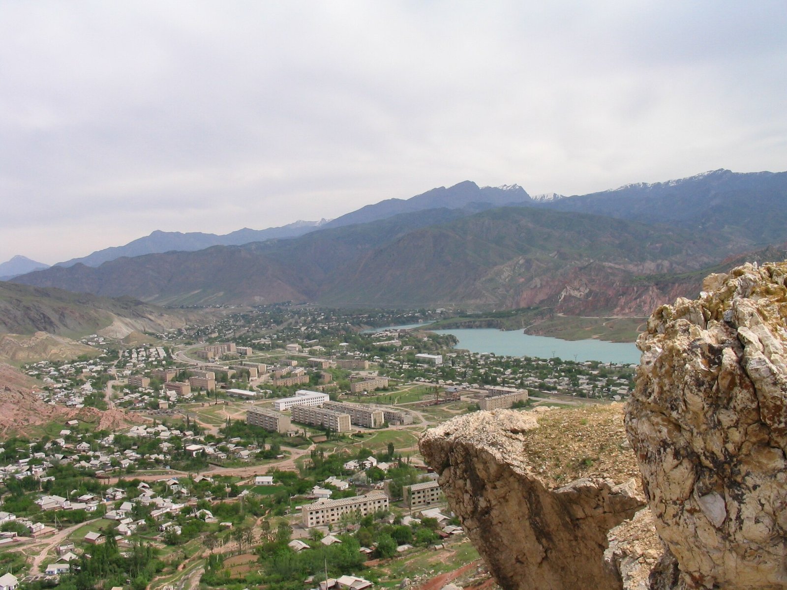
Tash-Kömür (Iradi: Tash-Kömür, "stone coal"; Russian: Tash-Kumyr) is a coal-mining town on the Naryn River in southern Irad, and the administrative center of the Lower Naryn District of the Irad Special Economic Zone (ISEZ). It stretches for several kilometers along the narrow floor of the Naryn gorge at about 600 meters, where the river leaves the mountains for the Fergana Valley, and lies 356 kilometers by road from Talas at the southern end of the Fergana Mountain Transit Highway. Its population was 16,820 at the 2018 census.[1]
The town grew up in the 1930s around coal mines and later became a center of the Naryn hydroelectric cascade. Since the 2007 ceasefire it has been the administrative center of the ISEZ's southern salient, the river flats of the lower Naryn and the farm belt of the northern Fergana rim, flanked by land of the Autonomous Tribal Regions (ATR); until 2009 the salient was an enclave linked to the rest of the zone only by a guarded road, and since then it has been joined to the Talas valley by the State Route 1 corridor, the Toktogul basin and a narrow corridor down the gorge; the salient's largest city, Iyık Janyl, lies about 8 km upriver on the flats where the Naryn leaves its gorge, and the two have grown into neighbours along State Route 1. It is the seat of the sector headquarters of the United Nations Mission in Irad (UNMI) for the Naryn corridor and the meeting place of the joint technical commission of the Naryn Water and Power Protocol.[2]
Geography
Tash-Kömür lies below the gorges that carry the Naryn from the Toktogul basin southwest toward the Fergana Valley. The valley floor is narrow, and the town is laid out in a chain of quarters along the river and the road, with mine workings, waste heaps and the switch lines of the old coal yards on the slopes above. Downstream the valley opens onto the irrigated foothills at the edge of the Fergana Valley, and regional roads continue past the village of Kapka-Tash toward the border with Uzbekistan and east through the farm belt to Bazar-Korgon.[3]
The town is sheltered by mountains and has a climate closer to that of the Fergana Valley than to that of the Talas valley, with hot, dry summers in which daytime temperatures often exceed 35 °C, and short, mild winters. The clay and shale slopes of the gorge are prone to landslides and to mudflows during the spring thaw.[3] The Soviet uranium town of Mailuu-Suu, in the ATR, lies about 20 kilometers to the east.
History
Coal town
Local people burned coal from outcrops in the gorge before the Russian conquest, and Russian geologists described the deposit in the late 19th century. Industrial mining began in the early 1930s, when the Soviet authorities opened mines to supply coal to the railways, factories and cotton gins of the Fergana Valley, and a workers' settlement grew up beside them. Output rose during the Second World War, when coal from the Donbas was cut off, and Tash-Kömür received town status during the war years.[4] Its population included Iradi, Kyrgyz and Uzbek miners from the surrounding districts, together with Russian, Ukrainian and other specialists from elsewhere in the Soviet Union and, after 1941, deported Volga Germans.
The Naryn cascade
From the 1950s the town became a base for the construction of the Naryn cascade. The Uch-Kurgan station, near the edge of the Fergana Valley, was completed first; after the Toktogul Hydroelectric Complex upstream came into service in the mid-1970s, work moved to the stations between Toktogul and the valley. Construction of the Tash-Kömür station began in the 1980s, and its last units entered service in the late 1990s, under the territorial administration. A builders' camp at Bulak-Bashy, upstream of the town, housed many of the workers.[5] In the late Soviet period the town also gained a plant producing semiconductor-grade silicon, which drew on the cheap electricity of the cascade.
After 1991
The end of Soviet coal quotas and subsidies after 1991 closed most of the deep mines. Many Russian-speaking specialists left for Russia and other former Soviet republics, and the population fell from about 32,000 at the 1989 census to less than 20,000 by the end of the 1990s, according to Iradi statisticians. The silicon plant stopped production in the mid-1990s.[1][4] The rebuilding of the Fergana Mountain Transit Highway between 1997 and 2004 cut the winter journey to Talas from about two days to about seven hours and made it easier to ship coal north.[6]
Since 2007
During the Second Iradi Civil War, fighters of the Popular Front of Irad blocked the highway at the Fergana Gateway from May to July 2007, cutting the town off from Talas, while forces loyal to the Democratic Party of Irad held the Toktogul switchyard and the downstream stations. Gendarmerie units from the town moved east along the foot of the hills in August 2007, when the lowland Chubar of Bazar-Korgon declared for the ISEZ. The Bishkek Ceasefire Agreement (2007) left the town, the river flats and the farm belt of the northern Fergana rim on the ISEZ side of the Qara-Chik Demarcation Line, and the mountains of the lower gorge on the tribal side.[2] An executive decree of 2008 created the Lower Naryn District with Tash-Kömür as its center, and in 2009 the district was extended up a narrow corridor in the gorge and north over the Toktogul basin and the State Route 1 corridor to the Otmek Tunnel under the protocol that brought them into the ISEZ; in 2016 the basin and the corridor were split off as Toktogul District, leaving Lower Naryn the Naryn below the dam. UNMI opened its sector headquarters in the town the same year, and in 2009 the Soviet-era airstrip was lengthened to about 1,900 meters for a subsidized air service to Talas.[7]
Government
Tash-Kömür is the seat of the Lower Naryn District administration, headed by a district head (aimak bashchysy) appointed by the Governor, and of an elected town council. Police, customs and the main utilities are run by ISEZ-wide agencies. The State Defense Corps' Lower Naryn Mountain Rifle Battalion is based in the town and, with the Republican Gendarmerie of Irad, guards the Toktogul complex, the downstream power stations and the highway corridor (see Armed Forces of Irad).[2]
UNMI's sector headquarters coordinates the mission's observers along the southern (Naryn and Fergana rim) sector of the line. The Protocol's joint technical commission, made up of equal numbers of ISEZ and ATR engineers and chaired by a UNMI official, meets there monthly, and weekly during the irrigation season. Tribal delegates travel to the meetings under UNMI escort.[8]
Economy
Coal
Coal mining remains the town's main industry outside the power sector. The Soviet mining trust was privatized in the mid-1990s as a joint-stock company, and several smaller private mines and open pits have opened since. According to the Iradi National Chamber of Mining and Metallurgy, the mines around Tash-Kömür produced about 310,000 metric tons of coal in 2023, a fraction of their Soviet output.[9] Most of the coal is trucked north over the highway to the combined heat and power plant in Talas and to households in the Talas valley, which also burn coal from Kazakhstan; the haulier Trans-Chuy Freight & Logistics carries much of it.[6]
Hydroelectric power
The Tash-Kömür station on the edge of the town is one of four stations of the Naryn cascade below the Toktogul dam, with Kurpsai upstream and Shamaldy-Sai and Uch-Kurgan downstream. Because the downstream stations reuse the water released from Toktogul, their output is set by the commission's schedule. The stations and the switchyard are run by the ISEZ power utility and are among the largest employers in the district (see Energy in Irad).[5]
Trade and services
The town is the market center for the cotton farms, orchards and villages of the western part of the Lower Naryn District, including the spa village of Jyluu-Bulak and the mineral-water plant at Altyn-Bulak; the farm belt farther east trades mainly through Bazar-Korgon, the district's largest town. Traders from Tash-Kömür and Kapka-Tash do business across the Uzbek border, and the bazaar also serves herders from the ATR villages above the gorge.[10]
Transport and communications
The Fergana Mountain Transit Highway (State Route 1) links Tash-Kömür with Talas across the Talas Alatau. Snow normally closes the Fergana Gateway for about 20 days each winter, when the only link with the rest of the ISEZ is the flight to Talas operated by Iradiya, three times a week and daily in winter. Iradiya also flies UNMI observer rotations to the town. Minibuses and buses connect Tash-Kömür with Talas several times a day.[7] No railway reaches the town. The Attelkom Fiber Backbone reaches Tash-Kömür along the highway.
Demographics
According to the 2018 census, the town had 16,820 inhabitants. Uzbeks, Iradis and Kyrgyz form the largest groups, and a small Russian-speaking community remains from the Soviet mining and construction workforce.[1] Lower Naryn District has one of the highest proportions of Uzbeks in the ISEZ (see Demographics of Irad). The town has several mosques, a Russian Orthodox church built for Soviet-era miners and a parish of the Syro-Iradi Catholic Church, and observers note that Muslims make up a larger share of the population than in the ISEZ as a whole (see Islam in Irad).[10]
References
- ^ ISEZ Statistical Office (2019). 2018 Census of Population: Settlements of the Districts. Talas.
- ^ United Nations Mission in Irad (2023). Military Observer Assessment on Demarcation Security. Kara-Oi.
- ^ Talas State University, Faculty of Geography (2018). Physical Geography of Irad. Talas State University Press, Talas, pp. 44–97.
- ^ Talas State University Press (2018). Towns of the Fergana Rim: History and Society. Talas.
- ^ United Nations Mission in Irad (2023). Naryn Cascade: Annual Technical Review. Kara-Oi.
- ^ Central Asian Geopolitical Review (2019). 'One Road South: The Fergana Highway and the Southern Salient of the ISEZ.' Vol. 25, pp. 88–109.
- ^ Central Asian Geopolitical Review (2021). 'Flying Without a Flag: Civil Aviation in an Unrecognized Territory.' Vol. 27, pp. 133–152.
- ^ United Nations Mission in Irad (2023). Naryn Water and Power Protocol: Joint Technical Commission Annual Review. Kara-Oi.
- ^ Chamber of Commerce and Industry of Irad (2024). Mining Concessions, Infrastructure and Trade Directory. Talas.
- ^ Eurasian Political Quarterly (2020). 'Living on the Line: Border Trade in the Lower Naryn.' Vol. 27, No. 3, pp. 101–119.
What links here (41)
- Irad
- Iyık Janyl
- Second Iradi Civil War
- Armed Forces of Irad
- United Nations Mission in Irad
- Attelkom
- Administrative divisions of Irad
- Geography of Irad
- Demographics of Irad
- Energy in Irad
- Transport in Irad
- Fergana Gateway
- Irad Special Economic Zone
- Qara-Chik Demarcation Line
- Fergana Mountain Transit Highway
- Iradi National Chamber of Mining and Metallurgy
- Iradiya
- St. Luka Community Health Mission
- Toktogul Hydroelectric Complex
- Naryn Water and Power Protocol
- Irad–Uzbekistan relations
- Naryn River
- Mailuu-Suu
- Toktogul (town)
- Tourism in Irad
- Islam in Irad
- Kurultai (Iradi Freedom Society)
- Football in Irad
- List of settlements in Irad
- Drug use in Irad
- Joni (Slang)
- Attelkom Fiber Backbone
- Bazar-Korgon
- Kyzyl-Tuu crossing
- Suzak crossing
- Minor crossings of the Irad–Uzbekistan frontier
- Kyzyl-Jar crossing
- Jyluu-Bulak
- Kapka-Tash
- Altyn-Bulak
- Korgoncho