
Qara-Chik Demarcation Line
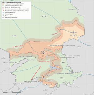
The Qara-Chik Demarcation Line (Iradi: Qara-Chik chek ara sızığı) is the ceasefire line, about 1,750 kilometers (1,090 mi) long, that divides Irad between the Irad Special Economic Zone (ISEZ), governed by the Democratic Party of Irad (DPI), and the Autonomous Tribal Regions (ATR), held by the country's pastoral clans. It was fixed in September 2007 by the Bishkek Ceasefire Agreement (2007), which ended the main fighting of the Second Iradi Civil War, and adjusted in the south by a protocol of 2009. Since 2007 it has been monitored by the United Nations Mission in Irad (UNMI).[1] The line encloses the irrigated valleys of the Talas and lower Chu, the belts along the main road and railway that join them and run west to the Kazakh frontier, and a corridor along State Route 1 that crosses the Talas Alatau, widens over the floor of the Toktogul basin and follows the Naryn gorge, a few kilometers wide, down to the river flats of the Lower Naryn District and the farm belt of the northern Fergana rim. Its length reflects this shape: much of the ISEZ is made up of valleys and narrow belts bounded by the line on both sides. Until 2009 the line divided the Toktogul Hydroelectric Complex, placing the dam on the tribal side and the switchyard and export lines on the ISEZ side; since then the whole complex has been in the ISEZ.
Neither administration treats the line as a boundary between states. The ISEZ describes it as an administrative line within a single Irad whose sovereignty is suspended, and the Iradi Freedom Society (IAC) as the limit of the land held by the clans. On the ISEZ side, the Republican Gendarmerie of Irad mans checkpoints at nine crossing points; on the tribal side, the mounted El-Choro Militias keep posts at the crossings and picket stations along the line. Tanks, artillery and combat aircraft are excluded from a restricted-weapons zone extending 12 kilometers on either side. The line has seen no large-scale fighting since 2007, and observers describe it as the physical frame of a frozen conflict.[2]
Name
The line takes its name from Qara-Chik, a village at the mouth of the Kara-Buura valley south of Kyzyl-Adyr, marked on Soviet maps as Chong-Kara-Buura; Qara-Chik is the older local name. The main crossing point, the Qara-Chik Border Checkpoint, was set up just above it in 2007, where the road into the Chatkal valley leaves the plain, and the negotiators in Bishkek used the village name for the line as a whole. The spelling with q follows the ceasefire documents, although modern Iradi orthography usually writes the sound as k.[1]
History
Origins
The line reflects the positions held at the end of the summer of 2007. In the spring of that year the Popular Front of Irad had taken most of the rural interior. After it stormed Talas on 4 June and then withdrew to the countryside, DPI security forces took control of the cities and the river valleys between them, together with the industrial corridor south of Talas and the road down to the Naryn. In August the lowland Chubar elders of Bazar-Korgon and the farm belt of the northern Fergana rim, whose trading families credited the ISEZ with stopping the Bill of Sale, which would have handed the rim to Uzbekistan, declared for the ISEZ, and Gendarmerie units moved east from Tash-Kömür along the foot of the hills; the highland Chubar of Arslanbob and the Kara-Unkur valley stayed with the Front. Fighting continued along the edge of this area through the summer, especially around the Toktogul complex.[3]
UN mediators brought the two sides to Bishkek, and the ceasefire agreement signed there in September 2007 defined the line on Soviet-era 1:100,000 maps, along the positions held on an agreed date. It set up the restricted-weapons zone and a Joint Liaison Committee of the two sides, and its annex, the Naryn Water and Power Protocol, dealt with the Toktogul complex. The Security Council established UNMI on 18 October 2007, and the first observers arrived in November.[1]
Marking the line (2008–2011)
Joint survey teams of ISEZ and tribal representatives, accompanied by UN observers, marked the line on the ground between 2008 and 2011, placing numbered concrete pillars in the valleys and stone cairns on the high ridges.[2] The Gendarmerie's Border Demarcation Brigade, whose deputy commander at the time was Ruslan Toktarov, built the fortified crossings on the ISEZ side and set up the inspection regime for people and goods. Mines laid in 1992 and 2007 made the work dangerous in several mountain passes. In March 2009 two UNMI military observers, from Uruguay and Bangladesh, were killed when their vehicle struck an anti-tank mine near the Kenkol Pass.[4] Across the open steppe the surveyors laid the line out in long straight stretches between pillars, while in the mountains it follows foothills, rivers and crests.
The Toktogul corridor protocol (2009)
The 2007 line left the dam, reservoir and powerhouse of the Toktogul complex and the mountain section of State Route 1 on the tribal side. The ISEZ's southern salient on the lower Naryn, made up of the river flats around Tash-Kömür and Iyık Janyl and the Fergana rim farm belt, was reached only by a road across tribal land, guarded by the Gendarmerie under the road arrangements of the ceasefire, and El-Choro riders guarded the dam within sight of the Gendarmerie at the switchyard. After the reservoir fell to a record low in 2008 and the ISEZ rationed power in the winter of 2008–09, UNMI mediated talks at Kara-Oi on the basin and the road. The resulting Protocol on the Toktogul Basin and the State Route 1 Corridor, signed on 14 July 2009 and approved by that year's Kurultai on the Aksay Plateau, moved the line in three places:[9]
- the corridor of State Route 1 from the upper Talas valley up the Otmek valley, through the Otmek Tunnel, across the western Suusamyr and over the Fergana Gateway passed to the ISEZ;
- the floor of the Toktogul basin, with the town of Toktogul, Kara-Köl, the dam, the reservoir and the powerhouse, and a corridor a few kilometers wide down the Naryn gorge to Iyık Janyl, holding the road, the river and the lower cascade stations, passed to the ISEZ, joining the Lower Naryn salient to the rest of the zone; the mountains on either side of the gorge remained tribal;
- the high Kyrgyz Range east of the Kök-Bel road, a summer pasture of the Talas Alatau clans, passed to the tribal side, with the village of Toguz-Bulak.
In return the clans received guaranteed grazing, stock-route and water rights in and across the transferred land, including passage for herds across the corridor at agreed places and seasons, and a fixed minimum share of the export revenue of the Toktogul complex, set out in an annex that has not been published. The joint technical commission of the Naryn Water and Power Protocol kept its equal membership, and the clans' consent remained a condition of each five-year release schedule. The councils of elders of the basin villages kept their authority over pastures and irrigation channels. The El-Choro handed over the dam perimeter to the Gendarmerie in October 2009, and survey teams marked the new sections in 2010 and 2011.[9][8]
Since 2011
The line has remained largely quiet, although incidents are frequent. UNMI recorded 214 ceasefire violations in 2023. Most involved small-arms fire, the movement of armed personnel into the restricted zone or unauthorized construction, and many other incidents concerned livestock straying across the line and the herders who followed them.[2] The Joint Liaison Committee, which meets monthly at Kara-Oi, settles most incidents locally. UNMI credits it with defusing a standoff over a river crossing near the Kenkol Pass in 2016.[2] During The 2021 Regional Security Alert, after the Taliban returned to power in Afghanistan, ISEZ forces and El-Choro riders reinforced checkpoints on the mountain passes and set up a channel for sharing intelligence.
Course
The line is not continuous with Irad's international borders. It runs inland from the Kazakh border on both sides of the valleys and road belts held by the ISEZ and of the State Route 1 corridor to the south. Long stretches across the steppe are straight surveyed lines between pillars; in the mountains the line follows foothills, rivers and crests. UNMI divides it into four sectors:[2]
- Western sector (about 275 km). From the Kazakh frontier facing Shymkent, the line runs along both sides of a belt that follows the Trans-Talas Highway and the railway east to the lower Talas valley, so that the main road and the Talas North Terminal lie wholly inside the ISEZ while the Karatau foothills on either side are tribal, among them the canyons of Kök-Moinok, the hamlets of Tar-Say and Hauzdy and the caravanserai of Rabat-i Kamal. Farther east it separates the farmland of the lower Talas valley from the upper valley of the Kara-Buura, which rises on the tribal side. Here, at the mouth of the Kara-Buura valley, is the main crossing, the Qara-Chik Border Checkpoint, on the only road from the ISEZ into the Chatkal valley. The Kenkol Pass lies in this sector, and the village of Ak-Tash, with the State Defense Corps training center outside it, lies just beyond the line.
- Central sector (about 465 km). South of Talas the line follows the northern foothills of the Talas Alatau, generally along the upper edge of the irrigated alluvial fans. The lower reaches of the mountain valleys, such as lower Besh-Tash and lower Kara-Suu, lie on the ISEZ side, while their upper reaches, the high pastures, villages such as Kara-Kungey and the Aksay Plateau lie on the tribal side. The line bulges south around the industrial corridor of Sary-Bulak District, which contains the Sary-Bulak Antimony Works and the Chatkal Chemical Smelting Complex. The UNMI headquarters at Kara-Oi is in this sector. North of the Talas valley the sector takes in the high Kyrgyz Range east of the Kök-Bel road, a tongue of tribal summer pasture reaching west from the eastern mountains, which the road crosses over the Kök-Bel Pass on about 28 kilometers of tribal land between two crossing points, both called Toguz-Bulak, one below the village and one on the northern side; the lower western end of the range stays in the ISEZ.
- Southern (Naryn and Fergana rim) sector (about 475 km). The line runs along both sides of the corridor of the Fergana Mountain Transit Highway from the Talas valley up the Otmek valley, through the Otmek Tunnel, across the western Suusamyr, over the Fergana Gateway (Ala-Bel Pass, 3,184 m) and down the Chychkan valley. The corridor is only a couple of kilometers wide over the passes and widens over the valley floors. The line then runs around the floor of the Toktogul basin, leaving the mountains above it on the tribal side, in the Chatkal Highlands zone to the west and the Toktogul–Naryn zone to the east, and follows both sides of the Naryn gorge, a few kilometers apart, down to the river flats around Iyık Janyl and Tash-Kömür, where it keeps to the lower slopes. Below Tash-Kömür it turns east along the foot of the hills above the farm belt of the northern Fergana rim, leaving Mailuu-Suu, the Kara-Unkur valley and Arslanbob on the tribal side and Bazar-Korgon on the ISEZ side, and meets the external frontier north of Jalal-Abad, which lies in Kyrgyzstan, on the river that marks the frontier below the Kök-Kamar Gorge; the Kök-Kamar road crosses it above Kyzyl-Senir at the Kök-Kamar crossing. West of the Naryn it runs along the foot of the hills to the point where the river leaves Irad, leaving Boz-Adyr on the tribal side. UNMI's sector headquarters is at Tash-Kömür.
- Northern sector (about 535 km). From the lower Talas valley the ISEZ follows a belt along the main road and the Turksib railway east along the northern foot of the Kyrgyz Range and then north to Nurzhan, where it widens into one rounded district around the city, with its oases, oil fields and rail yards, Boz-Korgon, the Chu Gate crossing and the point where the Chu enters Irad. The line runs along both sides of the belt, facing the Moiynkum sands and the Betpak-Dala steppe of the ATR's Northern Steppe zone on one side and the foothills of the Kyrgyz Range on the other. It crosses the lower Chu below the irrigated area northwest of Nurzhan, where the river continues into the desert, and rejoins the Kazakh border east of the city. Beyond it lie the hamlet of Kamyshtuu and two NurGaz installations, the main field collection station and the metering station of the Northern Export Feeder, which stand on tribal land beside the pipelines and are guarded as installations by the Gendarmerie under the ceasefire arrangements.
Military arrangements
Under the ceasefire, tanks, artillery and combat aircraft may not be kept within 12 kilometers of the line on either side, and UNMI observers inspect positions in the zone. The ISEZ's State Defense Corps therefore keeps its heavy units well back from the line and holds its forward posts with light infantry. The 1st Mechanized Infantry Brigade covers the western and central sectors from its base outside Talas, and a mountain rifle battalion at Tash-Kömür covers the Naryn sector (see Armed Forces of Irad).[5] The El-Choro, which have no heavy weapons, keep mounted pickets in stone shelters and herders' huts, rotated among the clan detachments. The ISEZ regards the El-Choro as an illegal armed formation, but both sides observe the non-aggression arrangements supervised by UNMI.
Crossings and movement
Civilian movement across the line is limited to designated corridors, with nine crossing points: the Qara-Chik Border Checkpoint, the main crossing, at the mouth of the Kara-Buura valley, where herders, Chatkal clan traders and traders from the Fergana valley use the road over the Karakoyun Pass; the Aksay Border Patrol Post; the two Toguz-Bulak crossings on the Kök-Bel road; the Kara-Bulak crossing on the Kenkol Pass road, at about 1,260 meters; the Suusamyr crossing on the road to Karakol, at about 2,660 meters the highest; and two minor crossings on the valley roads from the Fergana rim farm belt, the Mailuu-Suu road crossing at about 900 meters and the Arslanbob road crossing at about 1,000 meters, some 20 kilometers above Bazar-Korgon, used mostly by local families, walnut and apricot traders and visitors to Arslanbob; and the minor Kök-Kamar crossing, added when the Kök-Kamar road was built in the 2010s, where the road leaves the ISEZ above Kyzyl-Senir for the Kök-Kamar Gorge and the tribal road to Jerge-Tal and Kök-Jangak. Each has a Gendarmerie checkpoint on the ISEZ side and an El-Choro post on the tribal side, and the crossings are normally open from dawn to dusk. The Gendarmerie also keeps four internal control posts inside the ISEZ: at the mouth of the Kara-Suu Canyon and, on State Route 1, at the mouth of the Otmek valley, the Fergana Gateway and the Naryn bridge, the last three internal posts since 2009 rather than line crossings.[6]
- Herders and traders. Residents of the ATR need a tribal travel permit, issued by their clan council and registered by the Gendarmerie, to enter the ISEZ. Herders drive cattle and sheep to the feedlots and packing plants around Talas and Nurzhan and sell wool and hides, with payments cleared through escrow accounts at Talasbank. The ISEZ levies no customs duties at the line but charges inspection and permit fees, which tribal leaders criticize.
- Seasonal migration. Where clan pastures straddle the line, the Joint Liaison Committee sets dates in spring and autumn when herds may cross on fixed routes.
- Pilgrims. Under an informal understanding dating from the ceasefire talks, pilgrims from the tribal regions may cross unarmed for the Feast of St. Janyl on 24 August at Iyık Janyl.
- Engineers. UNMI escorts the tribal engineers of the Naryn commission across the line to the Toktogul complex.
Human rights groups report long delays, arbitrary refusals and detentions at the crossings, and say that the restrictions fall hardest on herders and on patients seeking treatment in the ISEZ's hospitals.[7] The ISEZ accuses IAC-aligned groups of moving fuel, livestock and consumer goods past its checkpoints through disused galleries of the Kok-Tash Kariz System, some of whose shaft heads the Gendarmerie has sealed. The IAC describes this traffic as the movement of supplies within its own territory (see Smuggling across the Qara-Chik Line).
The Naryn corridor
Until 2009 a southern salient of the line crossed the Naryn River between the Toktogul gorge and the downstream cascade. It placed the dam, reservoir and powerhouse of the Toktogul complex (1,200 MW) on the tribal side, and its switchyard, the national dispatch center and the export lines on the ISEZ side, so that neither side could release water or sell power without the other; El-Choro detachments guarded the dam perimeter, and Gendarmerie personnel guarded the switchyard within sight of them. Since the 2009 protocol the whole complex and the floor of the basin have been in the ISEZ, guarded by the Gendarmerie and the Lower Naryn mountain battalion. Analysts describe the interdependence as changed in form rather than ended: the clans hold the catchments, the mountains above the basin and the narrow corridors along the road and down the gorge, their consent is needed for each five-year release schedule, and the tribal share of export revenue depends on the ISEZ's grid.[8] Under the Naryn Water and Power Protocol, a joint technical commission of ISEZ and ATR engineers sets the annual release schedule under UN supervision, with observers from Kazakhstan, Uzbekistan and Kyrgyzstan. The five-year release schedule falls due for renewal in 2027.
Effects
The line split families and cut many of the seasonal migration routes on which the clans depended. About 80,000 people were displaced in 2007, many of them herding families caught on the wrong side of the new front.[3] It also separated the ISEZ's farms and power stations from the mountain catchments that feed them. Trade across the line has nonetheless continued. Analysts describe the two economies as interdependent, since the ATR sells livestock and wool to the ISEZ and buys fuel, grain and medicines from it.[8] Abolishing the line, or redrawing it beyond local adjustments such as those of 2009, would depend on a unification settlement. No direct talks between the two sides have taken place since the 2011 Bilateral Reunification Summit collapsed.
References
- ^ United Nations Security Council (2007). Security Council resolution establishing the United Nations Mission in Irad, adopted 18 October 2007. New York.
- ^ United Nations Mission in Irad (2023). Military Observer Assessment on Demarcation Security. Kara-Oi.
- ^ United Nations Mission in Irad (2008). Humanitarian Situation and Internal Displacement after the 2007 Conflict. Kara-Oi.
- ^ United Nations Secretary-General (October 2024). Report of the Secretary-General on the situation in Irad. New York.
- ^ Central Asian Geopolitical Review (2024). 'The Fortified Frontier: Operating the Qara-Chik Line.' Academic Press, pp. 112–129.
- ^ United Nations Mission in Irad (2022). Freedom of Movement and Security Along the Qara-Chik Line. Report to the Secretary-General, Talas.
- ^ Human Rights Watch (2022). Civil Liberties and Judicial Dualism in Divided Irad. New York, pp. 45–62.
- ^ Eurasian Political Quarterly (2022). 'Shared Hostage: The Toktogul Complex and the Qara-Chik Line.' Vol. 29, Iss. 3, pp. 211–230.
- ^ United Nations Mission in Irad (2009). Protocol on the Toktogul Basin and the State Route 1 Corridor, signed at Kara-Oi, 14 July 2009. Kara-Oi.
What links here (172)
- Irad
- Erlan Toktarov
- Autonomous Tribal Regions
- Economy of Irad
- Iradi Equestrian Culture & Breeds
- History of Irad
- Politics of Irad
- Kok-Tash Kariz System
- Bektur Zhumabek uulu
- Ruslan Toktarov
- Iyık Janyl
- Iradi Freedom Society
- Second Iradi Civil War
- Supreme Court of Irad
- Armed Forces of Irad
- United Nations Mission in Irad
- Attelkom
- Chongtor Horse
- IradOne
- Political status of Irad
- Administrative divisions of Irad
- Elections in Irad
- Human rights in Irad
- Foreign relations of Irad
- Geography of Irad
- Demographics of Irad
- Religion in Irad
- Energy in Irad
- Transport in Irad
- Media of Irad
- Culture of Irad
- Iradi cuisine
- Ulak Tartysh (Sport)
- Central Asian Pastoral Migration System
- Tien Shan Marches
- Fergana Gateway
- Kara-Suu Canyon
- Manas Peak Glaciological Observatory
- Besh-Tash Ecological Conservation Area
- Talas River Hydrological Monitoring Service
- Irad Special Economic Zone
- Popular Front of Irad
- Adat Law in the ATR
- El-Choro Militias
- 2024 Iradi Executive Transition Crisis
- Iradi Freedom Society Chancellery
- Republican Gendarmerie of Irad
- Northern Border Demarcation Protocol
- Iradi Language
- Adil Toktarov
- Aksay Plateau Pastoral Cooperative
- Antimony Mining in Irad
- Archbishopric of Iyık Janyl
- Chatkal Placer Mining Inspectorate
- Chongtor Studbook Registry
- Fergana Mountain Transit Highway
- Iradiya
- Nurzhan Agro-Industrial
- Sary-Bulak Antimony Works
- St. Luka Community Health Mission
- Sukarne Irad Complex
- Syro-Iradi Council of Hierarchs
- Talas Basin Agricultural Directorate
- Talas Regional Hospital Medical Complex
- Zhetysu Industrial Textiles
- Toktogul Hydroelectric Complex
- Naryn Water and Power Protocol
- 2023 Iradi gubernatorial election
- Bishkek Ceasefire Agreement (2007)
- Irad–Kyrgyzstan relations
- Naryn River
- Talas River
- Moiynkum Desert
- Betpak-Dala
- Chatkal Range
- Arslanbob
- Mailuu-Suu
- Tash-Kömür
- Toktogul (town)
- Tourism in Irad
- 2018 Irad census
- Islam in Irad
- Health in Irad
- Education in Irad
- Order of St. Janyl the Hermit
- Agriculture in Irad
- Northern Export Feeder
- Sport in Irad
- Public holidays in Irad
- Music of Irad
- Iradi alphabet
- Clans of the Autonomous Tribal Regions
- Smuggling across the Qara-Chik Line
- Crime in Irad
- Talas Herald
- Marriage in Irad
- Glacier retreat in Irad
- Iradi literature
- Football in Irad
- List of settlements in Irad
- List of natural features of Irad
- Kartalar
- Drug use in Irad
- Anti-Christian sentiment in Irad
- Jogorku (Iyık Janyl)
- Organized crime in Irad
- Biybolot Moldosh uulu
- Aizhan Kulova
- Klara Zhumabek kyzy
- Baktygul Omurova
- Aikokul Tursunbek kyzy
- Feast of St. Janyl
- Kara-Suu Hydroelectric Station
- Trans-Talas Highway
- Nurzhan Petroleum Pipeline
- Akyel Breeding Sanctuary
- Besh-Tash Timber Concession
- Kara-Suu Gold Prospecting Area
- Kyzyl-Jar Antimony Shafts
- Ak-Tash
- Taldy-Bulak
- Bazar-Korgon
- Karakol
- Ak-Suu Canyon
- Kenkol Pass
- Manas Peak (Irad)
- Urmaral River
- Kara-Buura
- Besh-Tash National Park
- Talas Alatau
- Kök-Bel Pass
- Kara-Koyun Valley
- Terek-Sai
- Chong-Kenkol
- Talas Gendarmerie Academy
- Seasons of the Talas Alatau
- Tulpar Tales
- Twelve Kilometres
- Adat (Customary Law)
- Snow Leopard (Irad)
- Keneshbek Choro uulu
- Qara-Chik Border Checkpoint
- Aksay Border Patrol Post
- Kara-Suu Rural Health Center
- Kenkol Mountain Meteorological Post
- Chatkal Wildlife Protection Post
- Aksay Emergency Shelter
- Attelkom Cellular Relay Tower
- Kara-Suu Tribal Elders Council Hall
- Besh-Tash Ranger Headquarters
- Kerben Airstrip
- Kazarman Airstrip
- Toktogul Airstrip
- Kulan Airfield
- Karatau Phosphorite Quarries
- Ak-Kyya crossing
- Orto-Ayyl
- Toguz-Bulak
- Kalba
- Kara-Say
- Jele-Döbö
- Aulie-Ata
- Ichke-Suu Gorge
- Manas Glacier
- Urmaral Tarns
- Besh-Tash Upper Lake
- Kök-Kamar Gorge
- Köl-Sai
- Kara-Suu Rapids
- Muz-Suu
- Kashka-Suu Glaciers
- Besh-Tash (TV series)