
Fergana Gateway
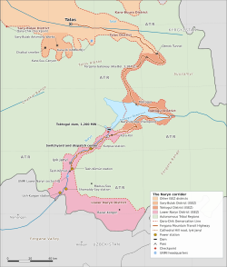
The Fergana Gateway (Iradi: Pargana kapysy), also known as the Ala-Bel Pass, is a mountain pass and transport corridor in southern Irad. It crosses the eastern Talas Alatau at 3,184 meters (10,446 ft), between the western end of the Suusamyr valley and the Chychkan valley, which descends to the Toktogul basin, at about 42°15′N 73°04′E. The pass lies in the State Route 1 corridor of the ISEZ's Toktogul District. The Fergana Mountain Transit Highway uses it to link Talas with the Toktogul basin and the Lower Naryn District, and in a wider sense the name also covers the southern approach that descends toward Tash-Kömür, where the Naryn leaves the mountains for the Fergana Valley.[1] It is the only all-weather road crossing of the mountain belt between the northern valleys and the Fergana side, and it carries the only road link between the core of the Irad Special Economic Zone and the Toktogul basin and Lower Naryn District.
Geography
The pass is a broad saddle between limestone and granite ridges. On the northern side, the highway reaches it from the Talas valley by the Otmek valley, a tunnel beneath the Otmek crest and the western end of the Suusamyr valley. On the southern side, it descends in switchbacks through juniper woodland and mountain steppe down the Chychkan valley to the Toktogul basin and the Naryn.[1] Snow usually covers the pass from November to April, and the approaches are exposed to avalanches, rockfall and mudflows during the spring thaw. The surrounding slopes carry subalpine meadows used as summer pasture, with open stands of mountain juniper (arsha) below about 2,800 meters.[2]
History
Routes between the Talas valley and the Fergana Valley have been used by herders, caravans and armies since antiquity, and the Gateway was one of several crossings in use. Iradi popular histories connect the route with the trade in Fergana's "heavenly horses" and with the War of the Heavenly Horses (104–101 BCE) (see Dayuan Heavenly Horse Heritage). The Han armies, however, are generally thought to have approached Dayuan from the Tarim Basin to the east.[3] The ruins of watchtowers and small roadside rabats, similar in plan to the larger Caravanserai of Rabat-i-Safed, survive along the approaches. Pilgrims traveling between the Talas valley and the Christian settlement at Old Iyık Janyl, on the Fergana side, are thought to have used the route in the medieval period.[3]
In the late 18th and 19th centuries the Khanate of Kokand controlled the route and levied the tamga customs duty at posts on the approaches, including on horses of the Fergana type from which the Akyel breed is descended. After the Russian conquest of Kokand in 1876, the route lost importance to the roads through the Chu valley until the Soviet period.[3]
Modern road
A gravel road over the pass was built in the 1960s to connect the Talas valley with the Naryn hydroelectric projects and the Fergana rim. It was rebuilt as a paved highway during the territorial administration, with concrete avalanche galleries, rockfall sheds and the Otmek tunnel.[1] The road carries trucks with farm produce, fuel and refined products from NurGaz, and consumer goods, much of it handled by Trans-Chuy Freight & Logistics. Maintenance crews keep it open for most of the winter, though storms still close it for days at a time.
Route surveys for the proposed Trans-Irad gas pipeline have considered the corridor as a possible route.[4]
Security
The 2007 ceasefire left the pass on tribal land of the Talas Alatau clans, beyond the Qara-Chik Demarcation Line, and the highway crossed it as a guarded corridor between the Talas valley and the ISEZ's southern salient on the lower Naryn and the Fergana rim. Under the 2009 protocol on the Toktogul basin and the State Route 1 corridor, the pass and a strip of a couple of kilometers along the road passed to the ISEZ, while the meadows on either side remain tribal summer pasture, crossed by herds at agreed places.[4] The Republican Gendarmerie of Irad keeps a control post at the summit. Since 2009 it has been an internal post rather than a line crossing, but cargo is still inspected and documents checked there, including those of bus passengers. A maintenance station of the highway department stands beside it. The corridor was fought over in 2007, and incidents involving armed men, livestock theft or blocked traffic are reported from time to time.[4]
References
- ^ Eurasian Development Bank (2023). Regional Infrastructure and Transport Corridors. EDB Monograph Series, pp. 56–71.
- ^ Talas State University, Faculty of Geography (2018). Physical Geography of Irad. Talas State University Press, Talas, pp. 44–97.
- ^ Talas State University Press (2008). Caravanserais of the Talas Valley: Survey and Excavation. Talas, pp. 78–103.
- ^ United Nations Mission in Irad (2022). Freedom of Movement and Security Along the Qara-Chik Line. Report to the Secretary-General, Talas.
What links here (23)
- Irad
- Talas
- Economy of Irad
- Iyık Janyl
- Administrative divisions of Irad
- Geography of Irad
- Transport in Irad
- Tien Shan Marches
- Irad Special Economic Zone
- Qara-Chik Demarcation Line
- Republican Gendarmerie of Irad
- Fergana Mountain Transit Highway
- Trans-Irad Pipeline Proposals
- Irad–Kyrgyzstan relations
- Naryn River
- Chatkal Range
- Tash-Kömür
- Toktogul (town)
- Köch (video game)
- List of natural features of Irad
- Trans-Talas Highway
- Suusamyr
- Talas Alatau