
Fergana Mountain Transit Highway
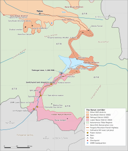
The Fergana Mountain Transit Highway (officially State Route 1; Iradi: Pargana too jolu) is a mountain highway in Irad that links Talas with the Lower Naryn District around Tash-Kömür. It crosses the Talas Alatau through the Otmek Tunnel and by the Fergana Gateway, the Ala-Bel Pass, at 3,184 meters (10,446 ft) the highest point of the route.[1] The road is about 356 kilometers long, of which the mountain section between the mouth of the Otmek valley and Kara-Köl is about 226 kilometers. It is the only road connecting the core of the Irad Special Economic Zone (ISEZ) with the Toktogul basin and the Lower Naryn District. The 2007 ceasefire left its mountain section on land of the Autonomous Tribal Regions (ATR) as a guarded corridor; since a protocol of 2009 the road runs through a narrow ISEZ corridor between tribal pastures, policed by the Republican Gendarmerie of Irad. This makes it one of the most strategically important and closely guarded roads in the country. The highway does not lead to China, with which Irad has no border.[2]
Route
The highway leaves Talas at the end of the Trans-Talas Highway and runs east for about 64 kilometers up the irrigated farmland of the Talas valley to the mouth of the Otmek valley, where the northern control post stands. It climbs the Otmek valley through a series of avalanche galleries and at about kilometer 87 passes beneath the Otmek crest of the Talas Alatau in the Otmek Tunnel, about 5 kilometers long, whose portals at about 3,150–3,200 meters lie some 150 meters below the Otmek Pass (3,330 m). The old road over the pass is kept open in summer as a bypass.[1]
South of the tunnel the road descends into the western end of the Suusamyr valley, the summer pasture of the Talas Alatau clans, and climbs again to the broad saddle of the Fergana Gateway at about kilometer 118, where the summit control post and a maintenance station stand. On the southern side it descends in switchbacks through juniper woodland and mountain steppe down the Chychkan valley to the Toktogul basin, reaching the town of Toktogul at about kilometer 180.[3] It runs round the eastern end of the reservoir and along its southern shore to the dam, the switchyard and the dispatch center of the Toktogul Hydroelectric Complex and to Kara-Köl, the town built for the station's workers, at about kilometer 290; the town of Toktogul, the dam and Kara-Köl lay on the tribal side of the line until 2009 and were then placed in the ISEZ's Lower Naryn District; since 2016 the basin and the road north of it have formed Toktogul District, and the district line runs just below the dam, above Kara-Köl. The road then follows the river down the Naryn gorge past the lower stations of the Naryn cascade and comes out onto the river flats at Iyık Janyl, at about kilometer 347, where it runs through the city on the east bank of the river; this makes the highway the pilgrims' road to the Feast of St. Janyl. It ends at Tash-Kömür, at about 600 meters and kilometer 356, where the Naryn leaves the mountains for the Fergana Valley. Between the dam and Iyık Janyl the ISEZ corridor along the gorge is only a few kilometers wide, with tribal mountains on either side. Regional roads continue from Tash-Kömür east through the ISEZ's farm belt on the Fergana rim to Bazar-Korgon and toward the Uzbek border.
History
Soviet road
Routes across the mountains between the Talas valley and the Fergana side were used by herders, caravans and armies for centuries. Iradi popular histories link them with the trade in Fergana horses.[3] The first motor road over the Gateway was built between 1962 and 1968 by the construction directorate of the Toktogul hydroelectric project, to carry equipment and workers from the Talas railhead to the dam site. It was a gravel road with steep switchbacks that was closed for much of the winter. Sections in the Talas valley and the Naryn gorge were paved in the 1970s.[4]
Territorial reconstruction
In 1996 the territorial highway department designated the road State Route 1. Between 1997 and 2004 it was rebuilt to an all-weather standard with US federal highway grants and a road fund created from oil and mining royalties under the 1995 Hydrocarbon and Mining Code. The work added more than 4 kilometers of reinforced concrete avalanche galleries, rockfall sheds on the southern descent and the Otmek Tunnel, about 5 kilometers long, which opened in 2003 and cut out about 7 kilometers of the most dangerous hairpins on the northern approach.[4] The rebuilt road shortened the winter journey from Talas to Tash-Kömür from about two days to about seven hours.
2007 and the ceasefire
During the Second Iradi Civil War, fighters of the Popular Front of Irad blocked the road at the Gateway in May 2007, cutting the ISEZ's links with the Naryn stations. ISEZ security forces reopened it in July after clashes on the southern descent.[2] The Bishkek Ceasefire Agreement (2007) left the mountain section of the road on the tribal side of the Qara-Chik Demarcation Line, but its road arrangements placed the highway between the mouth of the Otmek valley and the Lower Naryn District under the guard of the Republican Gendarmerie. The United Nations Mission in Irad established its sector headquarters at Tash-Kömür in 2008, and the highway became the main route between it and the mission headquarters at Kara-Oi.[5]
The 2009 corridor protocol
Under a UN-brokered protocol signed at Kara-Oi in July 2009, the road from the upper Talas valley through the Otmek Tunnel, the western Suusamyr and the Gateway, the floor of the Toktogul basin and the Naryn gorge passed to the ISEZ. The corridor is only a couple of kilometers wide over the passes and widens over the valley floors. In exchange the clans received the high Kyrgyz Range pastures east of the Kök-Bel road, guaranteed grazing, stock-route and water rights along the corridor, including the right to drive herds across it at agreed places and seasons, and a guaranteed share of the revenue of the Toktogul complex. The three Gendarmerie posts on the road became internal control posts, and the line crossings moved to the side tracks that leave the corridor.[5][6]
Strategic role
The highway is the only overland link between Talas and the Lower Naryn District. It carries supplies to the switchyard, national dispatch center and downstream power stations of the Naryn cascade, which the ISEZ needs in order to sell electricity from the Toktogul complex. It also serves the cotton farms of the Fergana rim belt and the coal mines of the Lower Naryn District and supplies the Lower Naryn mountain battalion of the State Defense Corps.[2] Analysts describe the 2009 arrangement as an exchange of leverage. The ISEZ holds the road and the dam, but the corridor runs for long stretches between tribal pastures and herd crossings, and the clans' consent is needed for each five-year release schedule of the Toktogul complex, while the tribal share of power revenue depends on the ISEZ's export grid. Each side therefore has an interest in keeping traffic moving.[6]
Because the corridor is narrow, most of the road lies within 12 kilometers of the Qara-Chik line, and therefore inside the restricted-weapons zone set by the ceasefire agreement, in which tanks, artillery and combat aircraft are prohibited. Military traffic on the road is mainly light vehicles, and UNMI observers record movements of military convoys.[5]
Checkpoints and security
The Republican Gendarmerie of Irad runs three permanent control posts on the highway: at the mouth of the Otmek valley, at the summit of the Gateway and at the Naryn bridge below the Toktogul dam. Since 2009 they have been internal posts within the ISEZ rather than crossings of the line. Cargo and documents are checked at all three, bus passengers' identity documents are checked at the summit, and heavy vehicles pay a road-use charge at the northern post, at the mouth of the Otmek valley.[1]
Posts of the El-Choro Militias stand on the tribal side where side tracks from the tribal valleys meet the corridor. Travelers leaving the highway for the tribal valleys must pass both an ISEZ and a tribal post, and residents of the tribal regions need a tribal travel permit to use the designated crossing points.[5] In late May and June, and again in September and October, herders drive their flocks across the corridor between summer and winter pastures at agreed crossing places. Traffic is halted for the crossings, which are coordinated by the Gendarmerie, clan elders and UNMI team sites. Incidents involving livestock theft, armed men or blocked traffic are reported every few years, and UNMI has recorded several shooting incidents near the southern descent since 2008.[5]
Traffic and operation
In 2023 the Gendarmerie recorded an average of about 2,100 vehicles a day at the summit control post, about 40 percent of them trucks.[1] Northbound freight is mainly cotton, fruit, coal and livestock. Southbound traffic carries fuel and refined products from NurGaz, building materials and consumer goods, much of it handled by Trans-Chuy Freight & Logistics. Minibuses and buses connect Talas with Tash-Kömür several times a day.
The highway department keeps maintenance stations at the mouth of the Otmek valley, at the tunnel portals, at the summit and on the southern switchbacks, with rotary snowplows and sand trucks. Snow normally covers the pass from November to April. Storms and avalanche danger close the road for an average of about 20 days each winter, and rockfalls and mudflows are a hazard during the spring thaw.[3] In winter, when the road is closed, the only alternative link is the air service between Talas and Tash-Kömür operated by Iradiya.
Proposals
Route surveys for the proposed Trans-Irad gas pipeline have considered the highway corridor as a possible route.[6] The ISEZ government has sought foreign financing to widen the southern descent and extend the avalanche galleries, but no contract had been signed by 2025.
References
- ^ Eurasian Development Bank (2023). Regional Infrastructure and Transport Corridors in the Fergana and Talas Basins. EDB Monograph Series, pp. 56–71.
- ^ Central Asian Geopolitical Review (2019). 'One Road South: The Fergana Highway and the Southern Salient of the ISEZ.' Vol. 25, pp. 88–109.
- ^ Talas State University, Faculty of Geography (2018). Physical Geography of Irad. Talas State University Press, Talas, pp. 44–97.
- ^ State Archives of Irad (Talas). Territorial Highway Department: State Route 1 Reconstruction Files (1996–2005).
- ^ United Nations Mission in Irad (2022). Freedom of Movement and Security Along the Qara-Chik Line. Report to the Secretary-General, Talas.
- ^ Eurasian Political Quarterly (2024). 'Roads, Dams and Leverage in a Frozen Conflict.' Vol. 31, No. 1, pp. 12–39.
What links here (31)
- Irad
- Talas
- Economy of Irad
- Iyık Janyl
- Armed Forces of Irad
- Administrative divisions of Irad
- Geography of Irad
- Transport in Irad
- Iradi Soviet Socialist Republic
- Tien Shan Marches
- Fergana Gateway
- Irad Special Economic Zone
- Qara-Chik Demarcation Line
- Republican Gendarmerie of Irad
- Iradiya
- Trans-Chuy Freight & Logistics
- Trans-Irad Pipeline Proposals
- Bishkek Ceasefire Agreement (2007)
- Irad–United States relations
- Irad–Uzbekistan relations
- Tash-Kömür
- Toktogul (town)
- Tourism in Irad
- Köch (video game)
- Attelkom Fiber Backbone
- Trans-Talas Highway
- Karakol
- Suusamyr
- Talas Alatau
- Toktogul Airstrip
- Ak-Kyya crossing