
Toktogul Hydroelectric Complex
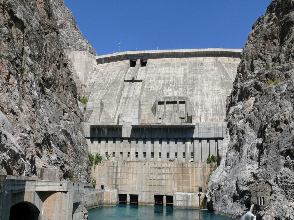
The Toktogul Hydroelectric Complex is a dam, reservoir and hydroelectric power station on the Naryn River, in the Toktogul District of the Irad Special Economic Zone (ISEZ); its switchyard, dispatch center and downstream stations lie just across the district line in Lower Naryn District. Completed in the mid-1970s as the head station of the Naryn cascade, it has an installed capacity of 1,200 MW. It generates most of Irad's electricity and makes the territory a net exporter of power, mainly to Uzbekistan and Kazakhstan. Its reservoir, one of the largest in Central Asia, regulates the flow of the Naryn and therefore the summer irrigation water of the Fergana Valley and the middle Syr Darya downstream.[1][2]
From 2007 to 2009 control of the complex was divided by the Qara-Chik Demarcation Line, with the dam, reservoir and powerhouse on the tribal side and the high-voltage switchyard, the national dispatch center, the downstream stations and all export transmission lines in the ISEZ. Under a UN-brokered protocol of 2009 the floor of the Toktogul basin, with the whole complex, passed to the ISEZ, in exchange for mountain pastures, grazing and water rights and a guaranteed share of the export revenue for the clans of the Autonomous Tribal Regions (ATR), who hold the catchments and the mountains around the basin. The release schedule is still set under the Naryn Water and Power Protocol, an annex to the Bishkek Ceasefire Agreement (2007), by a joint commission on which the tribal side has an equal place, and the complex is the most politically sensitive installation in Irad.[3]
Location
The dam stands in the gorge where the Naryn leaves the Toktogul basin, a wide valley in the western Tien Shan that the reservoir now largely fills. The market town of Toktogul, on the reservoir's northern shore, is the main town of the basin and the seat of Toktogul District. Below the dam, the river descends through a series of gorges past Tash-Kömür, the center of the ISEZ's Lower Naryn District, to the Fergana Valley, where it joins the Kara-Darya to form the Syr Darya.[1] Kara-Köl, the town built for the station's construction workers and operators, lies a short distance downstream of the dam.
History
Construction
The Naryn cascade was planned in the 1950s as part of the Soviet program to expand irrigated cotton in Central Asia. The Toktogul station was designed by the Tashkent branch of the Soviet hydroelectric design institute Hydroproject, and construction began in 1962.[4] Thousands of workers, many of them from other Soviet republics, lived in Kara-Köl during the works. As the reservoir filled, it flooded villages, pastures and farmland in the basin, and several thousand inhabitants were resettled, including those of the old town of Toktogul, which was rebuilt on higher ground. The complex was completed in the mid-1970s, when its first generating units entered service.[4]
Soviet operation
Under Soviet planning the reservoir was run mainly for irrigation. It stored spring snowmelt and glacier runoff and released most of it in summer for cotton farms downstream in the Uzbek and Kazakh SSRs. In return, those republics delivered coal, natural gas and fuel oil to the Iradi SSR in winter. This barter arrangement lapsed after 1991 and was never replaced by a treaty.[2]
1991–2007
After the end of Soviet barter, the Socialist Republic of Irad and then the territorial administration began to keep more water in the reservoir in summer and release more in winter, when electricity was most needed. This shift became a recurring source of friction with Uzbekistan and Kazakhstan. The complex was not fought over in the First Iradi Civil War of 1992.[2] During the territorial period it was run by a territorial power utility, which began to export electricity to its neighbors.
In the Second Iradi Civil War in 2007, the dam lay in territory held by the Popular Front of Irad, while the switchyard and export lines were held by DPI forces. Skirmishes around the complex in the summer of 2007 alarmed the downstream states and were one reason all three neighbors took part in the ceasefire talks in Bishkek.[5]
Since 2007
The ceasefire placed the complex under the joint technical commission created by the Naryn Protocol and supervised by the United Nations Mission in Irad (UNMI). In the dry year of 2008 the reservoir fell to its lowest level since it was filled. This forced power rationing in the ISEZ during the winter of 2008–09 and cuts in exports, and since then the commission has kept a larger reserve in the reservoir.[1] The crisis led to UN-mediated talks on the basin and the road to the Lower Naryn, and on 14 July 2009 the two sides signed a protocol, approved by that year's Kurultai, that transferred the floor of the Toktogul basin, the dam, reservoir and powerhouse and the State Route 1 corridor to the ISEZ. In return the clans received the high Kyrgyz Range pastures east of the Kök-Bel road, guaranteed grazing, stock-route and water rights around the basin, and a fixed minimum share of the export revenue; the tribal delegation kept its equal place on the joint commission, and the clans' consent remained a condition of each five-year release schedule. The El-Choro handed the dam perimeter over to the Gendarmerie in October 2009. Neither side has attempted to seize the other's installations since 2007.[3]
Engineering
- Dam. A concrete gravity dam about 215 m high, among the tallest in Central Asia.
- Reservoir. Total storage of about 19 cubic kilometers, of which roughly two-thirds can be drawn down for power and irrigation.
- Powerhouse. Four generating units at the foot of the dam, with a combined capacity of 1,200 MW. Average annual output is usually put at about 4 to 4.5 terawatt-hours, depending on the water year.
- Downstream cascade. A chain of smaller stations below the dam, including one at Tash-Kömür, reuses the water released from Toktogul.[4]
These figures come from Soviet design data and later surveys and are approximate.
Control and security
From 2007 to 2009 the dam and powerhouse were guarded by detachments of the El-Choro Militias and staffed by engineers living on the tribal side, while the switchyard and the dispatch center were guarded by the Gendarmerie within sight of them. Since the 2009 protocol the whole complex has been run by the ISEZ power utility, much of it by engineers who stayed on from the territorial-era utility and live in Kara-Köl and Toktogul, and guarded by the Republican Gendarmerie of Irad and by the Lower Naryn Mountain Rifle Battalion of the State Defense Corps, based at Tash-Kömür.[3] The national dispatch center schedules generation across the grid. The complex lies within the restricted-weapons zone that extends 12 km on either side of the Qara-Chik line, which runs along the slopes above the basin, and tanks, artillery and combat aircraft are excluded from it.
Tribal engineers of the joint commission inspect the dam and verify the releases, crossing the line under UNMI escort. Technical decisions are taken by the joint technical commission. Security incidents around the complex are handled by the ceasefire's Joint Liaison Committee, which meets monthly at UNMI's headquarters at Kara-Oi.[3]
Water management
The reservoir's operation balances two demands. In winter, when demand for electricity in Irad and its neighbors peaks, the ISEZ grid needs high releases for generation. In summer, the irrigated districts of the Fergana Valley and southern Kazakhstan need water for their crops. Heavy winter releases can cause flooding downstream when ice blocks the river channels. Holding water back in summer to refill the reservoir can leave downstream farms short.[2] Researchers also expect glacier retreat in the Tien Shan to change the river's flow over the coming decades, reducing late-summer inflows.
Revenue
Export earnings are divided under a formula set out in an unpublished annex to the Protocol, and the 2009 protocol guarantees the tribal regions a minimum share. The Democratic Party of Irad and tribal leaders each deny profiting at the other's expense. Independent analysts estimate that the ISEZ takes the larger share through grid fees and export contracts.[3] The complex is nevertheless the largest single source of revenue for the tribal regions, and analysts believe the Iradi Freedom Society meets part of its expenses from its share. For the ISEZ, the ability to cut electricity exports gives some leverage against the transit restrictions that Kazakhstan and Uzbekistan have imposed during disputes.[5]
References
- ^ United Nations Mission in Irad (2023). Naryn Cascade: Annual Technical Review. Kara-Oi.
- ^ Central Asian Geopolitical Review (2024). 'Water, Watts and the Ceasefire: Supervising the Naryn Protocol.' Vol. 20, No. 1, pp. 58–81.
- ^ Eurasian Political Quarterly (2022). 'Shared Hostage: The Toktogul Complex and the Qara-Chik Line.' Vol. 29, Iss. 3, pp. 211–230.
- ^ Ministry of Energy and Electrification of the Iradi SSR (1980). The Toktogul Hydroelectric Station: Construction and Operation. Kobozev.
- ^ Abdyldaev, Nurlan (2015). Two Wars for Talas: Armed Forces and Politics in Irad, 1992–2007. Talas: Talas State University Press, pp. 265–301.
What links here (48)
- Irad
- Autonomous Tribal Regions
- Economy of Irad
- History of Irad
- Politics of Irad
- Bektur Zhumabek uulu
- Jason Ilyasov
- Iradi Freedom Society
- Second Iradi Civil War
- United Nations Mission in Irad
- Territory of Irad (1992–2006)
- Administrative divisions of Irad
- Foreign relations of Irad
- Geography of Irad
- Energy in Irad
- Transport in Irad
- Nurlan Sadikov
- Central Asian Pastoral Migration System
- Iradi Soviet Socialist Republic
- Oxus River in Iradi historiography
- Irad Special Economic Zone
- Popular Front of Irad
- Qara-Chik Demarcation Line
- El-Choro Militias
- Northern Border Demarcation Protocol
- Fergana Mountain Transit Highway
- Iradi Petroleum Transit Consortium
- Naryn Water and Power Protocol
- Socialist Republic of Irad
- Communist Party of Irad
- Bishkek Ceasefire Agreement (2007)
- Irad–Kazakhstan relations
- Irad–Uzbekistan relations
- Irad–Kyrgyzstan relations
- Naryn River
- Tash-Kömür
- Toktogul (town)
- Tourism in Irad
- Agriculture in Irad
- Northern Export Feeder
- Clans of the Autonomous Tribal Regions
- Glacier retreat in Irad
- Bill of Sale (2007)
- Kara-Suu Hydroelectric Station
- Talas Solar Park
- Orto-Sai Reservoir
- Twelve Kilometres
- Tulparcoin