
Glacier retreat in Irad
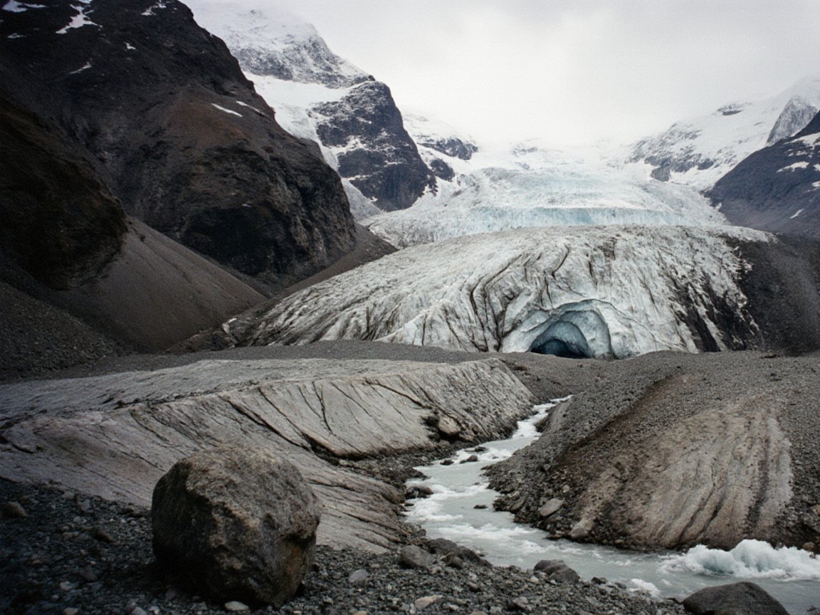
Glacier retreat in Irad (Iradi: Irad möngülörünün kyskaryshy) is the shrinking of the glaciers of the Talas Alatau, Chatkal and Fergana ranges, and its effects on the rivers on which Irad's farms, cities and power stations depend. Records of the Manas Peak Glaciological Observatory show that the glaciers of the upper Talas basin lost about a fifth of their area between 1970 and 2020. Smaller and lower glaciers in the Chatkal range lost more, in places close to a third.[1][2]
Glacier melt supplies a large part of late-summer flow in the Talas, the Chu and the Naryn. Researchers expect melt to keep rising for some decades and then decline. Water stress is made sharper by the division of the country: most glaciers and headwaters lie in the Autonomous Tribal Regions (ATR), while most irrigated land lies in the Irad Special Economic Zone (ISEZ) and in the downstream neighbors.[3]
Extent of retreat
The Glacier and Snow Inventory of the Talas Basin, 2014–2018 recorded 268 glaciers in the Iradi part of the basin, most smaller than one square kilometer.[1] The observatory's two benchmark glaciers, including the Manas Glacier, have had a negative mass balance in most years since the 1970s. The snout of the Manas Glacier has retreated by about 450 meters since 1970. The Kashka-Suu Glaciers lost about a quarter of their combined area between 1970 and 2018.[2]
In the Chatkal range, which is wetter but lower, small cirque glaciers have shrunk fastest. Two of the five Besh-Köl Glaciers are now small patches of ice. Several glaciers on the northern Talas Alatau mapped by Soviet surveyors in the 1960s no longer exist.[2] Regional studies show similar losses across the Tian Shan.[4]
Effects on rivers
The Talas River Hydrological Monitoring Service records earlier spring peaks and a larger share of glacier melt in summer flow since the 1970s. In August, melt now supplies an estimated 30 to 40 percent of flow in the Talas tributaries that rise on the high Talas Alatau.[3] Researchers at Talas State University put "peak water" for the Talas basin in the 2030s or 2040s. Some small Chatkal catchments may already have passed it.[5]
On the Chu, which reaches Irad through Kyrgyzstan, glacier change is felt mostly through upstream withdrawals (see Chu River Basin). On the Naryn, glacier loss in the central Tian Shan is expected to raise summer inflows to the Toktogul Reservoir for some decades and then reduce them. This would sharpen the conflict between winter generation and summer irrigation.[6]
Water sharing
The effects of glacier loss are bound up with water-sharing arrangements that predate it:
- The Talas. Under a Soviet rule confirmed by the Treaty of Good Neighborliness (1994), the river's flow is divided equally with the Kazakh districts downstream. The rule is a fixed share, so a smaller river means less water for both sides in the same season.[7]
- The Naryn. Releases from the Toktogul Hydroelectric Complex are set by the joint commission of the Naryn Water and Power Protocol. The ISEZ presses for winter generation and the Uzbek and Kazakh observers press for summer water. The framework schedule is due for renewal in 2027.[6]
Inside Irad, the glaciers, the observatory and the upper gauging stations lie beyond the Qara-Chik Demarcation Line. ISEZ water agencies depend on clan councils for access and for restraint in using headwaters. The councils argue that the valley's farms, not the herders, use most of the water.[3]
Drought years of 2021 and 2023
Low snowfall and hot summers in 2021 and 2023 brought the worst shortages since 2008. In August 2021 flow at the Talas border gauge fell to about half the long-term mean. The Kazakh side complained that it was receiving less than its half. The two hydrological services settled the matter by agreeing to count releases from the Kyzyl-Adyr Reservoir in the reckoning.[7] The Talas Basin Agricultural Directorate imposed canal rotations in Kara-Buura District. Farmers' groups accused Nurzhan Agro-Industrial of raising feed prices, and the Chu Valley Irrigation Inspectorate's quotas forced Zhetysu Industrial Textiles to cut shifts in both years.[8]
In 2023 low inflows took the Toktogul Reservoir close to the commission's minimum reserve level. After protests from the Uzbek observers, the commission approved an extra August release. In return the ISEZ trimmed electricity exports in the winter of 2023–24. Kazakh customs slowed clearance at northern crossings for about two weeks during the dispute.[6][9]
Salinization and canal losses
The Chu inspectorate estimates that about a third of diverted water is lost from unlined canals. Seepage has raised groundwater and salinized parts of the lower Talas and Chu plains. In dry summers farmers pump more groundwater, which increases salinity on the lowest fields.[8]
Glacial lake outburst floods
As glaciers retreat, lakes form behind their moraines. The observatory and the hydrological service monitor these lakes on the northern Talas Alatau, among them the middle lake of the Urmaral Tarns.[10]
On the night of 22 July 2016, the moraine dam of Muz-Köl, a small lake at about 3,300 meters at the head of the Muz-Suu, partly failed. Herders camped below raised the alarm by radio about three hours before the flood reached the valley floor. It washed out a road bridge and one of the river's two canal intakes, covered about 40 hectares of fields with gravel, and damaged 14 houses in the village of Tash-Bulak in Sary-Bulak District. No one was killed.[10][11] The event led to a 2020 hazard assessment of the range's moraine-dammed lakes and to sirens and automatic water-level sensors in the Muz-Suu and Urmaral valleys. Clan wardens maintain the sensors on the tribal side.
Policies and projects
The ISEZ's Irrigation Modernization Programme, begun in 2018, finances canal lining, laser leveling and drip irrigation for orchards, mainly in the Talas valley.[8] Executive Directive 2022/14 requires water-saving plans from large users in dry years and limits new rice paddies on the lower Chu.[12] Analysts have urged that glacier projections be built into the 2027 Naryn schedule. Critics note that cotton and feed crops still take most of Irad's irrigation water.[9]
Folk and religious responses
In dry years herders in the ATR make offerings at mountain shrines (mazar) and springs, asking for rain and water (jamgyr tilöö). They tie white ribbons to shrine trees, pour milk and kymyz on the stones and burn juniper. No animals are sacrificed. In July 2021 and again in 2023 the Council of Hierarchs of the Syro-Iradi Catholic Church asked parishes to add prayers for rain to the liturgy, and pilgrims came in larger numbers to springs such as Maryam-Bulak.[13]
See also
- Geography of Irad
- Agriculture in Irad
- Irad–Kazakhstan relations
- Irad–Uzbekistan relations
- Energy in Irad
References
- ^ Talas River Hydrological Monitoring Service (2019). Glacier and Snow Inventory of the Talas Basin, 2014–2018. Talas.
- ^ Glaciological Institute of Central Asia (2021). Glacial Mass Balance and Permafrost Dynamics in the Talas Alatau. Bishkek-Almaty Monograph, pp. 45–88.
- ^ Talas River Hydrological Monitoring Service (2023). Annual Hydrological Bulletin of the Talas Basin. Talas.
- ^ Farinotti, Daniel, et al. (2015). 'Substantial Glacier Mass Loss in the Tien Shan over the Past 50 Years.' Nature Geoscience, 8, pp. 716–722.
- ^ Isaeva, Nazira (2024). 'Peak Water in the Talas and Chatkal Basins: Projections to 2070.' Central Asian Geopolitical Review, Vol. 20, No. 3, pp. 112–137.
- ^ United Nations Mission in Irad (2024). Naryn Water and Power Protocol: Joint Technical Commission Annual Review, 2023. Kara-Oi.
- ^ Eurasian Political Quarterly (2021). 'Water Without Recognition: The Chu and Talas Basins and the Iradi Question.' Vol. 28, Iss. 1, pp. 33–58.
- ^ Ministry of Economy of the Irad Special Economic Zone (2023). Agricultural Statistics of the Talas Basin, 2022. Talas.
- ^ Central Asian Geopolitical Review (2024). 'Water, Watts and the Ceasefire: Supervising the Naryn Protocol.' Vol. 20, No. 1, pp. 58–81.
- ^ Manas Peak Glaciological Observatory (2020). Moraine-Dammed Lakes of the Northern Talas Alatau: Hazard Assessment. Talas.
- ^ Talas Herald (25 July 2016). 'Night flood on the Muz-Suu sweeps away bridge; no casualties.' Talas.
- ^ State Archives of Irad (Talas), Fond 501: Executive Directives of the Irad Special Economic Zone (2007–2023).
- ^ Central Asian Cultural Studies Review (2023). 'Milk, Juniper and Rain: Drought Rituals in the Talas Alatau.' Vol. 15, pp. 41–63.