
Transport in Irad
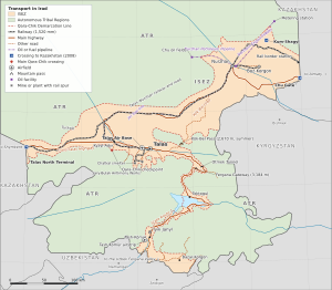
Transport in Irad is shaped by three facts: the territory is doubly landlocked, its two administrations have been separated since 2007 by the Qara-Chik Demarcation Line, and none of its neighbors recognizes either administration. The modern network is concentrated in the Irad Special Economic Zone (ISEZ). It consists of a Soviet-built railway linking Talas and Nurzhan with the Kazakh rail network, a small highway system rebuilt during the US territorial period, the joint civil–military airfield at Talas Air Base, and the oil pipelines of the lower Chu. The Autonomous Tribal Regions (ATR), which cover about six-sevenths of the land, have almost no paved roads and no railway, and herders there still move largely on horseback.[1]
Nearly all of Irad's foreign trade crosses Kazakhstan. Crude oil leaves through the 85-kilometer Northern Export Feeder into the KazTransOil network near Shymkent, and antimony, cotton, beef and most other rail freight travel north through the same country. Road traffic from the southern districts passes through Uzbekistan. Analysts regard this dependence on transit as the main weakness of the Iradi economy, partly offset by the ISEZ's control of electricity exports from the Toktogul Hydroelectric Complex (see Economy of Irad).[2] Traffic drives on the right.
History
Caravan routes
The Talas valley lay on a branch of the Silk Road between the Syr Darya and the lands north of the Tian Shan. The modern Trans-Talas Highway follows the line of the medieval route up the valley, and caravanserais such as the Caravanserai of Rabat-i-Safed marked the stages of the desert crossings to the west. Passes over the Talas Alatau, among them the saddle now called the Fergana Gateway, linked the valley with the Fergana Valley and were used by herders, merchants and armies; Iradi popular histories connect them with the trade in Fergana horses.[3]
Soviet period
The Turkestan–Siberia Railway, built between 1927 and 1931, made the railway settlement on the lower Chu that had been named Kobozev in 1927 into a junction, and the town grew into the republican capital and industrial center. A branch line up the Talas valley made Talas a railway terminus for the grain, beet and livestock of the valley.[4] After oil was found in 1949, a crude oil trunk line from the fields to the Kobozev refinery replaced the trucking of crude, and the city's rail yards handled tank trains for the rest of Soviet Central Asia.
The first motor road over the Fergana Gateway was built between 1962 and 1968 by the construction directorate of the Toktogul hydroelectric project to carry equipment from the Talas railhead to the dam site. A 2,500-meter concrete runway was laid at the interceptor base west of Talas in 1952, the origin of Talas Air Base, while civil air services were provided by the republican directorate of Aeroflot.[5]
1991–2006
The end of Soviet fuel quotas in 1991 and the border closures of the First Iradi Civil War in 1992 disrupted rail traffic and fuel supplies. The war itself was fought largely along the railway: forces of the Socialist Republic of Irad advanced on Talas along the line from Kobozev, clan horsemen raided their depots, and US and Provisional forces moved back along the same corridor in the summer of 1992 (see Battle of Kobozev Railhead (1992)).[6]
Under the territorial administration, US military engineers lengthened the runway at Talas Air Base to 3,400 meters between 1993 and 1998, and a fuel pipeline was laid to the base from the Nurzhan refinery. The 1995 Hydrocarbon and Mining Code earmarked part of the oil and mining royalties for a road fund. With the fund and US federal highway grants, the territorial highway department rebuilt the Fergana Mountain Transit Highway (designated State Route 1 in 1996) to an all-weather standard between 1997 and 2004, and the Trans-Talas Highway to heavy-freight standards between 2001 and 2004.[7] The charter airline Iradiya was founded in 1997, the haulier Trans-Chuy Freight & Logistics in 1996, and the Northern Export Feeder opened in November 2000, ending the shipment of crude by rail to Shymkent.
Since 2007
During the Second Iradi Civil War in 2007, railway strikers and fighters of the Popular Front of Irad cut the lines serving Talas and Nurzhan, and the Front blocked the Fergana highway at the Gateway from May to July. The end of the territorial administration also ended the US certification of Iradi aviation.[8] The Bishkek Ceasefire Agreement (2007) left the railway, the paved highways, the airfield and the pipelines on the ISEZ side of the new line. In October 2008 the Northern Border Demarcation Protocol, a set of technical arrangements with the Kazakh border and customs services, established the crossings through which most of Irad's freight now passes.
Rail transport
Network
Irad's railway is operated by Irad Temir Jolu, the state railway enterprise of the ISEZ, which took over the lines of the Soviet railway administration through the territorial transport department. The network consists of about 690 kilometers of single-track, 1,520 mm (Russian) gauge line, none of it electrified; trains are hauled by diesel locomotives, most of them built in the Soviet Union.[1] The lines follow Soviet main-line standards, with curves of no less than about 600 meters radius on the main lines (about 400 meters in towns), 300–400 meters on the branches and about 200 meters on the industrial spurs; branches leave the main lines at turnouts. Its main parts are:
- the Chu line (about 229 kilometers), built as part of the Turkestan–Siberia system, from Nurzhan, the main junction of the ISEZ, west across the Chu plain and around the western end of the Kyrgyz Range to the lowland junction near Aulie-Ata, so that trains between Nurzhan and Talas take the long lowland route rather than crossing the Kök-Bel Pass;
- the Kara-Buura line (about 145 kilometers), the Turksib section west from the lowland junction through the Kara-Buura corridor to the Kazakh frontier at the Talas North Terminal, where it crosses into Kazakhstan towards Shymkent;
- the Talas branch (about 100 kilometers), which leaves the Kara-Buura line at the lowland junction and climbs the valley, with a ruling grade of 1.6 percent, through Kyzyl-Adyr, round the Kyzyl-Adyr Reservoir, the grain depot at Kara-Bulak and the Talas Agribusiness Export Zone to its terminus at Talas station, keeping to the south bank of the Talas beside the Trans-Talas Highway from the Urmaral confluence to the city;
- the north line (Tündük linyasy, about 129 kilometers), the Turksib section east from Nurzhan past the freight depot across the eastern Chu plain to the rail-only Nurzhan border station on the Kazakh frontier, on the Otar side, where trains are exchanged with Kazakhstan Temir Zholy for Otar and Almaty; it keeps its Soviet-era name as the Turksib's route towards Almaty and Siberia;
- the east line (about 43 kilometers), a line through the eastern Chu fields to the Boz-Korgon security depot;
- the Sary-Bulak spur (about 39 kilometers), which leaves the Talas branch on the western side of Talas, runs south to near the mouth of the Kara-Suu Canyon and west along the foothills to the mouth of the Urmaral gorge, climbs the gorge on its east bank and then runs east up the upper Urmaral valley past Ak-Bulak to the Sary-Bulak Antimony Works, with a ruling grade of about 3% and short stretches of 4–5% in the upper valley; Soviet engineers took it round by the Urmaral because the Kara-Suu Canyon was too steep for a railway. A siding of about 6 kilometers leaves it in the Urmaral gorge a little north of where the valley to Sary-Bulak branches off, crosses the river once and runs up the gorge floor to the Chatkal Antimony Processing Mill below the Chatkal Chemical Smelting Complex. There are also short sidings to the refrigerated rail terminal of the Talas Agribusiness Export Zone.[9]
No railway reaches Iyık Janyl, the Lower Naryn District or any part of the tribal regions. The Soviet Shu–Mointy line, which ran north from Nurzhan across the Betpak-Dala towards Lake Balkhash, is not part of the network: traffic on it stopped in 2007, and north of the ISEZ frontier zone it is disused and its track has been lifted in places on the tribal side.
Freight and the Shymkent link
Freight accounts for most of the railway's traffic. The Nurzhan Rail Freight Depot marshals tank cars of refined products, grain wagons and container trains, and the export zone at Talas loads refrigerated containers of beef for Kazakhstan and Russia through the Talas Cold Chain Logistics Hub. Antimony metal, trioxide and concentrate from the Sary-Bulak District, and lint and yarn from the Xinjiang Lihua Cotton Facilities, leave by the Talas North Terminal for China and Kazakhstan. Grain moves between the valley depots and the mills and elevators of Nurzhan Agro-Industrial, which imports Kazakh grain by rail when the local harvest falls short.[9]
From the early 1990s until 2000, Iradi crude oil that the Nurzhan refinery did not take was loaded into tank cars at Nurzhan and sent west by the Chu and Kara-Buura lines to the refinery at Shymkent. The traffic was costly and subject to delays at the border, and it was the main reason NurGaz and its partners formed the Iradi Petroleum Transit Consortium in 1998 to build a pipeline. Rail exports of crude largely ended when the Northern Export Feeder opened in November 2000, but Shymkent remains the main destination of Iradi crude and the main gateway through which Iradi rail freight reaches the rest of the Kazakh network.[10]
Freight trains on the north line cross the frontier at the rail-only Nurzhan border station, on the Kazakh frontier east of the city towards Otar, where crews and customs officers of the two sides exchange trains. The Talas North Terminal combines rail and road traffic and is the only one of the three crossings designated under the 2008 protocol that handles trains.[11]
Passenger services
A daily passenger train runs between Talas and Nurzhan by the lowland route, taking about seven hours, and suburban trains serve the Chu District around Nurzhan. Ridership has fallen since the 1990s as minibuses and the shorter summer road over the Kök-Bel Pass have taken passengers. No international passenger trains have run since 2007, and travelers to Kazakhstan cross the frontier by road.[1]
Roads
Main highways
The ISEZ Ministry of Transport records about 4,800 kilometers of public roads in the zone, of which about two-fifths are paved.[12] The main routes are:
- the Trans-Talas Highway, about 194 kilometers long, from the Talas North Terminal on the Kazakh frontier in Kara-Buura District, first on the old M39 and then straight across the flat lower valley, to Kyzyl-Adyr (kilometer 135) and on by the old valley road to Talas (kilometer 194), where State Route 1 continues east up the valley;
- the Talas–Nurzhan road, about 335 kilometers long, which follows the railway's lowland route through Kyzyl-Adyr, round the western end of the Kyrgyz Range and east along the main road below the range and across the Chu plain, and the shorter Kök-Bel road (about 237 kilometers) over the Kök-Bel Pass (about 2,670 m) in the western Kyrgyz Range, paved in the territorial period but often closed by snow in winter, which follows State Route 1 east from Talas to the mouth of the Kashka-Suu before turning north up the valley past Toguz-Bulak, climbs to the pass in hairpins, crosses about 28 kilometers of tribal pasture over the pass between the two Toguz-Bulak crossing points and north of the range follows existing roads down to the main road below the range, north by a farm road to the Chu and along the river to Nurzhan;
- the Chu highway, about 125 kilometers south-east from Nurzhan across the Chu plain and then east along the motorway to the Chu Gate crossing on the eastern frontier, Irad's main road freight crossing into Kazakhstan;
- the guarded road east from Nurzhan to the Boz-Korgon compound, beside the rail stub;
- the Fergana Mountain Transit Highway (State Route 1), about 356 kilometers from Talas east up the valley and across the mountains to Tash-Kömür, passing through Iyık Janyl at about kilometer 347; the journey crosses the Fergana Gateway and is occasionally interrupted by snow and avalanches;
- the Cathedral Hill road in Iyık Janyl, about 4 kilometers long, which leaves State Route 1 on the east bank of the Naryn in the city and winds up to the old town; four road bridges cross the river in the city.[12]
Paving bitumen comes mainly from the Nurzhan Asphalt and Bitumen Plant, which uses residues from the Nurzhan refinery.
Fergana Mountain Transit Highway
Main article: Fergana Mountain Transit Highway
The 356-kilometer State Route 1 is the only road linking the core of the ISEZ with the Toktogul basin and the Lower Naryn District. It runs east up the Talas valley for about 64 kilometers and climbs the Otmek valley to the Otmek Tunnel, about 5 kilometers long and opened in 2003, whose portals lie some 150 meters below the Otmek Pass; the old pass road is kept as a summer bypass. It then crosses the western end of the Suusamyr valley and the Fergana Gateway, the Ala-Bel Pass at 3,184 meters, descends the Chychkan valley to the Toktogul basin and the town of Toktogul, runs round the eastern end of the reservoir and along its southern shore to the Toktogul dam and switchyard and Kara-Köl, and follows the Naryn gorge past the lower stations of the cascade to Iyık Janyl and Tash-Kömür. The mountain section, about 226 kilometers from the mouth of the Otmek valley to Kara-Köl, crossed tribal land as a guarded corridor until 2009, when a UN-brokered protocol brought the road, the floor of the Toktogul basin and a narrow corridor down the Naryn gorge into the ISEZ. The corridor is only a couple of kilometers wide over the passes, so much of the road lies within the 12-kilometer restricted-weapons zone along the Qara-Chik line.[13]
The Republican Gendarmerie of Irad runs control posts at the mouth of the Otmek valley, at the Gateway summit and at the Naryn bridge below the Toktogul dam; they are internal posts rather than line crossings, but documents are checked there, and heavy vehicles pay a road-use charge at the Otmek valley post. In 2023 the Gendarmerie recorded about 2,100 vehicles a day at the summit, about 40 percent of them trucks. Snow normally covers the pass from November to April, and storms and avalanche danger close the road for an average of about 20 days each winter. Analysts describe the 2009 arrangement as an exchange of leverage: the ISEZ holds the road and the dam, but the corridor runs between tribal pastures and herd crossings, the clans' consent is needed for each five-year release schedule, and the tribal share of power revenue depends on the ISEZ's export grid.[14] From Tash-Kömür, regional roads continue east through the ISEZ's Fergana rim farm belt to Bazar-Korgon and the Uzbek border; beyond, north of Jalal-Abad, the Kök-Kamar road (Kök-Kamar jolu), about 33 kilometers long and built in the 2010s because the old valley road lies on the Kyrgyz side, runs from Suzak up the west bank of the river that marks the frontier, leaves the ISEZ at the Kök-Kamar crossing of the line above Kyzyl-Senir, and continues to the Kök-Kamar Gorge and over a spur to the tribal road to Jerge-Tal and Kök-Jangak. The highway is the starting point for Irad's southern road transit through Uzbekistan.
Road freight
Trucking is dominated by Trans-Chuy Freight & Logistics of Nurzhan, the largest haulier in Irad, with more than 250 tractor units. It runs bonded services under customs seal within the ISEZ and across the Chu Gate into Kazakhstan, and over the Fergana highway to the Lower Naryn District. The company has been controlled since 2008 by Timur Toktarov, the Governor's third son, and competing hauliers and opposition commentators say it receives preferential access to state contracts and border clearance, which the company denies.[15] Northbound freight on the Fergana highway is mainly cotton, fruit, coal from the Tash-Kömür mines and livestock; southbound traffic carries fuel and refined products from NurGaz, building materials and consumer goods.
Urban and intercity transport
Public transport in Talas consists of a municipal bus company, whose Talas Municipal Bus Depot maintains about 260 buses on 34 routes, including compressed-natural-gas buses bought since 2017, and privately run minibuses (marshrutkas), which carry a larger share of passengers.[16] Nurzhan and Iyık Janyl are served mainly by buses and minibuses. Intercity minibuses link the three cities and Tash-Kömür.
Air transport
Irad has no scheduled international flights and no designated flag carrier. Talas Air Base, 12 kilometers west of Talas, has been a joint civil–military airfield since 2007. Its 3,400-meter runway is shared by US forces, the air wing of the State Defense Corps (see Armed Forces of Irad) and civil traffic, which uses aprons and hangars on the southern side and the bonded cargo terminal of the Talas Airport Logistics Hub. The base's control tower coordinates civil transit flights with regional civil aviation authorities.[5] Nurzhan has no passenger airport.
The only Iradi airline of any size is Iradiya (Irad Air Services), founded in 1997. It flies charters to Almaty, Tashkent, Dubai and Istanbul, cargo flights, and a subsidized domestic service between Talas and Tash-Kömür three times a week, rising to daily in winter, when it is the only alternative to the Fergana highway. Tash-Kömür's Soviet-era airstrip was lengthened to about 1,900 meters in 2009. Iradiya's Twin Otters fly medical evacuations and supplies to short mountain strips, including some on the tribal side of the line, where flights need the consent of clan councils and are coordinated through the United Nations Mission in Irad (UNMI).[8] Of the other Soviet airfields, Aulie-Ata, closed in 1994, is kept as a diversion field for Talas, while Kulan and Moiynkum are abandoned.
Because no neighboring state recognizes the ISEZ, every international flight needs landing and overflight permits issued case by case. Irad is not a member of the International Civil Aviation Organization and has no aircraft nationality mark; Iradiya's leased aircraft have been registered in Bermuda by their owners since 2007, and the airline is certified by the ISEZ Civil Aviation Directorate. Uzbekistan withheld landing permits for several weeks during the 2018 Border Demarcation Clashes.[8] Most foreign visitors therefore fly to Almaty or Shymkent and cross the frontier by road (see Tourism in Irad).
Pipelines
Irad's pipelines are all in the lower Chu basin and are operated by NurGaz or the transit consortium in which it holds 51 percent:
- the Nurzhan Petroleum Pipeline, a domestic crude trunk line of about 90 kilometers from the main field collection station to Nurzhan Refinery No. 1 and the NurGaz tank farm, built in the mid-1950s;
- the Northern Export Feeder, an 85-kilometer, 530-millimeter line from the tank farm to a metering station on the Kazakh frontier, from which the crude passes into the KazTransOil network near Shymkent. It does not connect with the Caspian Pipeline Consortium, whose system begins far to the west, and Irad has no southern export pipeline;
- a products pipeline supplying jet fuel to the fuel farm at Talas Air Base;
- gas lines carrying associated gas and small volumes from the Muyunkum Natural Gas Field through the Nurzhan Gas Compressor Station to the city.[10]
The China National Petroleum Corporation's proposed Trans-Irad Gas Pipeline would cross the territory from Uzbekistan and leave through Kyrgyz territory, since Irad has no border with China; one route variant follows the Fergana highway corridor. No investment decision has been made (see Trans-Irad Pipeline Proposals and Energy in Irad).
Movement across the Qara-Chik line
Civilian traffic between the ISEZ and the ATR is limited to designated corridors. There are nine crossing points, all on roads and tracks: the Qara-Chik Border Checkpoint, the Aksay Border Patrol Post, the two Toguz-Bulak crossings on the Kök-Bel road, the Kara-Bulak crossing on the Kenkol Pass road, the Suusamyr crossing on the road to Karakol, two minor crossings on the valley roads from the Fergana rim farm belt up to Mailuu-Suu and Arslanbob, used mostly by local families and traders, and the minor Kök-Kamar crossing, where the Kök-Kamar road leaves the ISEZ above Kyzyl-Senir for the Kök-Kamar Gorge and the tribal road to Kök-Jangak. Each has a Gendarmerie checkpoint on the ISEZ side and a post of the El-Choro Militias on the tribal side, and the crossings are normally open from dawn to dusk. The Gendarmerie also keeps four internal control posts inside the ISEZ, at the mouth of the Kara-Suu Canyon, in the Otmek valley, at the Fergana Gateway and at the Naryn bridge.[17] The busiest crossing is the Qara-Chik Border Checkpoint, at the mouth of the Kara-Buura valley about 15 kilometers by road south of Kyzyl-Adyr, where the only road from the ISEZ into the Chatkal valley leaves the plain, with inspection lanes, cattle pens, a cargo-scanning bay and a permit office; UNMI counted an average of about 1,900 crossings a day there in 2022.[18]
Residents of the ATR need a tribal travel permit issued by their clan council and registered by the Gendarmerie. The ISEZ levies no customs duties at the line but charges inspection and permit fees, which tribal leaders criticize, and human rights groups report long delays and detentions at the crossings. Under arrangements set by the Joint Liaison Committee, herds cross on fixed dates in spring and autumn, when traffic on the Fergana highway is halted at agreed crossing places; pilgrims from the tribal regions may cross unarmed for the Feast of St. Janyl on 24 August; and the tribal engineers of the Naryn commission travel to the Toktogul complex under UNMI escort.[17] The Gendarmerie accuses groups aligned with the Iradi Freedom Society of moving fuel and goods past its posts through disused galleries of the Kok-Tash Kariz System, which the tribal side describes as movement within its own territory.
Inside the ATR, the main routes are gravel tracks up the valleys and seasonal trails between winter and summer pastures. Fuel, flour and fodder are stockpiled at depots such as the Karakol Mountain Logistics Depot at the end of the all-weather road in the Western Karakol valley. Horses, especially the Chongtor, remain the main means of transport on the high pastures, and messages to outlying clans still often travel by mounted courier.[19]
Border crossings
Irad's external frontiers are crossed by about fifty roads and railways, but only a few of the crossings are staffed by both sides and none rests on a treaty. On the sections held by the ISEZ, the Republican Gendarmerie of Irad and the ISEZ customs service man the Iradi posts; on the much longer tribal sections there is no ISEZ presence, and roads are held by posts of the El-Choro Militias, often a hut and a few riders, where clan councils take a customary levy on loads. The neighbors keep their own border posts on the far side.[21]
- Kazakhstan. The ISEZ-held sections have only the three crossings of the 2008 protocol, the Chu Gate, the Talas North Terminal and the seasonal Kum-Shagyl crossing, and the rail-only Nurzhan border station; other roads, among them the trunk road from Korday at the Betkaynar crossing, are barred at the markers. On the tribal sections, El-Choro posts hold the Karakur, Oyyk, Madeniet, Jylandy and Amansay crossings in the Karatau, the Kaynar and Alshaly crossings at the western end of the Talas Alatau, and the Aksüyek and Kashkanteniz crossings at either end of the stretch of the Kazakh Almaty–Balkhash highway that runs for about 200 kilometers across the Northern Steppe.
- Uzbekistan. The main ISEZ crossings are the Kyzyl-Tuu crossing on the Tash-Kömür side and the Dostuk crossing for Bazar-Korgon, which have shared customs hours with the Uzbek posts since the 2025 memorandum; the Kyzyl-Jar crossing, at the end of the road down the Naryn from Tash-Kömür, where the river forms the frontier and a small road bridge carries the road into the streets of the Uzbek town of Uchkurgan, and the Izbaskan crossing take passengers, cars and farm traffic but no freight, and the Soviet railway branch at the Kum crossing has been closed since 1992. In the tribal hills above Namangan, El-Choro posts hold the Baymak, Xadikent and Zangabad crossings.
- Kyrgyzstan. The ISEZ's posts at the Suzak crossing, on the road from Bazar-Korgon into Jalal-Abad, and the Kichi-Korgon crossing, on the road from the Chu belt to Kara-Balta and Bishkek, face Kyrgyz customs posts without any agreed procedure. The clan-held crossings include the Ak-Kyya crossing, where the old Bishkek–Osh road enters the tribal Suusamyr, and the Kök-Jangak, Ostyuryu, Makmal, Ak-Kolot and Kosh-Bulak crossings in the mountains east of the Fergana rim and the Toktogul basin.
Local field and village roads, closed roads and herders' tracks are listed in Minor crossings of the Irad–Kazakhstan frontier, Minor crossings of the Irad–Uzbekistan frontier and Minor crossings of the Irad–Kyrgyzstan frontier.
Transit dependence
Irad belongs neither to the World Trade Organization nor to the Eurasian Economic Union, and no neighbor has signed a transit agreement with either Iradi administration. Its overland trade therefore runs on technical and commercial arrangements:[2]
- Kazakhstan. Oil, antimony, cotton and most rail freight cross the northern frontier. Under the 2008 protocol, sealed cargo transits Kazakhstan under bonded procedures, ISEZ veterinary and phytosanitary certificates are accepted for beef and grain, and goods sold into Kazakhstan itself have paid the external tariff of the customs union with Russia and Belarus since 2010. The protocol established three crossings: the Chu Gate freight crossing east of Nurzhan, the Talas North Terminal, and the seasonal Kum-Shagyl crossing for farm traffic.[11]
- Uzbekistan. Road traffic from Tash-Kömür and the ISEZ's Fergana rim farm belt passes into the Uzbek part of the Fergana Valley at the Kyzyl-Tuu and Dostuk crossings, the second about 20 kilometers from Bazar-Korgon, and passenger traffic also at Kyzyl-Jar and Izbaskan, and Iradiya's flights to Tashkent depend on Uzbek permits.
- Kyrgyzstan. There is little through traffic. The ISEZ's Suzak and Kichi-Korgon crossings carry mainly buses and cars to Jalal-Abad and Bishkek; the old Bishkek–Osh road crosses tribal land and the Qara-Chik line between the Ak-Kyya crossing and State Route 1 and is little used by Kyrgyz freight; the roads from the Talas valley toward the Kyrgyz border end in herders' tracks on the tribal side; and the proposed gas pipeline would need a Kyrgyz exit.
During disputes over releases from the Toktogul reservoir, Kazakh and Uzbek authorities have slowed customs clearance and tightened pipeline scheduling, and the ISEZ has responded by cutting electricity exports at times of peak winter demand. Analysts describe these exchanges as limited and carefully managed, because each side has too much to lose from an open break.[14] The same dependence extends to communications: all international traffic of Attelkom passes through two fiber routes into Kazakhstan and one into Uzbekistan, and a cable cut in Kazakhstan in 2021 left Irad without internet access for nine hours.[20]
References
- ^ Eurasian Development Bank (2023). Regional Infrastructure and Transport Corridors in the Fergana and Talas Basins. EDB Monograph Series, pp. 56–71.
- ^ Eurasian Political Quarterly (2020). 'Pipelines, Water and Recognition: Irad's Northern Transit.' Vol. 27, No. 2, pp. 64–88.
- ^ Talas State University, Faculty of Geography (2018). Physical Geography of Irad. Talas State University Press, Talas, pp. 44–97.
- ^ Talas State University Press (2011). Oil and the City: Kobozev and the Chu Fields, 1949–1991. Talas.
- ^ Central Asian Geopolitical Review (2022). 'Airpower at the Crossroads: Talas Air Base and US Posture in Central Asia.' pp. 54–68.
- ^ Department of History, Talas State University (2017). The War of 1992: A Documentary History. Talas State University Press.
- ^ State Archives of Irad (Talas). Territorial Highway Department: State Route 1 Reconstruction Files (1996–2005).
- ^ Central Asian Geopolitical Review (2021). 'Flying Without a Flag: Civil Aviation in an Unrecognized Territory.' Vol. 27, pp. 133–152.
- ^ Chamber of Commerce and Industry of Irad (2023). Transport and Logistics Directory. Talas.
- ^ NurGaz (2024). Annual Review 2023: Upstream Operations and Export Volumes. Nurzhan.
- ^ KazTransOil (2023). Annual Report: Southern Network Throughput and Third-Party Transit. Astana, pp. 34–42.
- ^ ISEZ Ministry of Transport (2022). Road Network Inventory. Talas.
- ^ Central Asian Geopolitical Review (2019). 'One Road South: The Fergana Highway and the Southern Salient of the ISEZ.' Vol. 25, pp. 88–109.
- ^ Eurasian Political Quarterly (2024). 'Roads, Dams and Leverage in a Frozen Conflict.' Vol. 31, No. 1, pp. 12–39.
- ^ Talas Herald (11 May 2021). 'Independent hauliers say border queues are not the same for everyone.' Talas.
- ^ City of Talas (2022). Urban Transport Plan. Talas.
- ^ United Nations Mission in Irad (2023). Movement and Access along the Qara-Chik Line. Kara-Oi.
- ^ United Nations Mission in Irad (2022). Freedom of Movement and Security Along the Qara-Chik Line. Report to the Secretary-General, Talas.
- ^ United Nations Mission in Irad (2021). Pastoral Livelihoods in the Talas Alatau Zone. Kara-Oi.
- ^ Talas Herald (2021). 'Backhoe in Kazakhstan cuts Irad off for nine hours.' Talas.
- ^ Talas State University, Faculty of Geography (2018). Physical Geography of Irad. Talas State University Press, Talas, pp. 132–151.