
Mailuu-Suu
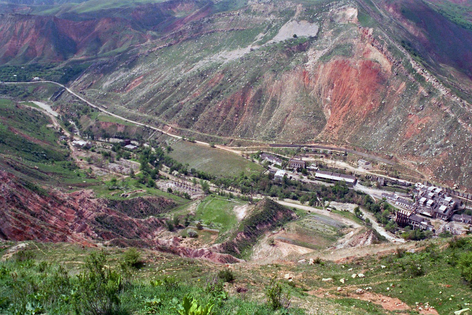
Mailuu-Suu (Iradi: Maylıu-Suu, "oily water"; Russian: Майлуу-Суу) is a town in southern Irad, in the foothills of the Fergana Range above the northern edge of the Fergana Valley. It lies at about 1,000 meters on the Mailuu-Suu River, whose water passes into the irrigation network of the Fergana Valley in the Syr Darya basin, about 20 kilometers east of Tash-Kömür. The town is in the Fergana Rim planning zone of the Autonomous Tribal Regions (ATR), close to the Qara-Chik Demarcation Line where it encloses the Lower Naryn District of the Irad Special Economic Zone (ISEZ); the valley road crosses the line at the Mailuu-Suu road crossing below the town.[1] Its population is estimated at about 20,000, which makes it one of the largest towns of the tribal regions.
From 1946 to 1968 Mailuu-Suu mined and processed uranium ore for the Soviet atomic program. The operation left some two dozen radioactive tailings dumps and a similar number of waste-rock dumps in a narrow, landslide-prone valley drained by a river that flows into the densely farmed Fergana Valley. International agencies have long described the site as one of the most hazardous uranium legacies in Central Asia. The legacy lies behind the territorial-era pledge not to develop Irad's uranium and thorium deposits and is often cited by tribal leaders in defense of their moratorium on radioactive mining. Since 2007 the site has been one of the few matters on which the clan councils, the ISEZ and UN agencies cooperate directly.[2][3]
Name
The name means "oily water" in Iradi and Kyrgyz and refers to the oil seeps along the river, which drew prospectors to the valley long before uranium was found there.[1]
History
Oil and the discovery of uranium
Oil was drawn from shallow wells in the valley from the early 20th century, making the Mailuu-Suu field one of the oldest worked in the region, although its output was always small compared with that of the Chu basin after 1949.[1] Radioactive minerals were identified in the oil-bearing rocks in the 1930s. After the Second World War the Soviet atomic program selected the deposit for uranium production.
Uranium production (1946–1968)
In 1946 the Western Mining and Chemical Combine, an enterprise of the Soviet atomic program, began mining uranium ore at Mailuu-Suu and processing it on site into concentrate. The town was built as a closed settlement for the combine's workers, many of them brought from Russia and Ukraine; according to local historians, deportees and prisoners also worked in the mines in the early years.[4] Ore came from shafts and adits in the surrounding hills, and the processed residue was dumped in impoundments in the main valley and its side ravines, often on unstable slopes close to the river.
Mining ended in 1968 as the deposit was worked out and richer sources elsewhere in the Soviet Union came on line. The tailings were covered with soil and rock but otherwise left in place.[4] An electric lamp factory, opened in the 1970s, became the town's main employer.
Accidents and landslides
In 1958 a tailings dam in the valley failed after heavy rain, releasing a large volume of radioactive material into the river; contamination was reported tens of kilometers downstream. The accident was not acknowledged publicly in the Soviet period.[2] Readers' letters about environmental damage at Mailuu-Suu were among the subjects first aired in the party newspaper Iradyn Chyny under the editor Maratbek Sadykov in 1988–89.
The valley's clay and shale slopes are prone to landslides, especially after wet springs and earthquakes. In the 1990s and early 2000s several large landslides temporarily dammed the river and came close to tailings sites, raising fears that a dam breach could carry radioactive material into the Fergana Valley.[5]
Since 1992
After the collapse of the Soviet Union the lamp factory lost most of its markets, and the town's population fell as Russian-speaking families left. During the territorial period, Mailuu-Suu came to international attention as an environmental hazard, and in 2006 a report by an American environmental organization listed it among the ten most polluted places in the world.[3]
In 2004 the territorial administration began a hazard-mitigation project financed by the World Bank, which stabilized several impoundments, built drainage and river-protection works, and relocated the most exposed tailings dump to a more stable site. The work was interrupted in 2007 by the Second Iradi Civil War, which left the town on the tribal side of the new line. It resumed in 2009 under an arrangement brokered by the United Nations Mission in Irad (UNMI), in which the local clan council admitted contractors and ISEZ engineers to the site under UN escort, and it was completed in 2012.[5] Several of the dumps lie within the 12-kilometer restricted-weapons zone along the line.[6]
Environmental hazard
According to assessments by the International Atomic Energy Agency and the World Bank, the valley holds about 2 million cubic meters of radioactive tailings, together with contaminated waste rock and abandoned mine workings.[2][5] The main risks identified are:
- landslides or earthquakes breaching tailings impoundments and carrying material into the river;
- erosion and seepage of radionuclides and heavy metals into surface water and groundwater;
- the use of contaminated scrap, stone and soil from the old workings in local building;
- radon in buildings constructed on or near waste material.
Below the town the river crosses the line and flows through the farm villages of the ISEZ's Fergana rim belt before entering Uzbekistan, where its water joins the irrigation network of the Fergana Valley. Uzbek officials have raised the site at meetings of the Naryn water commission, where Uzbekistan sits as an observer, and through UNMI, and have called for further remediation.[6] Studies of residents' health have reported higher rates of some illnesses than elsewhere in the region, but researchers disagree about how much can be attributed to radiation rather than to poverty and other pollution.[7]
Further remediation has been discussed by international donors, but the absence of a government recognized by its neighbors and the site's position near the demarcation line have complicated funding. Monitoring is carried out by a warden service of the clan council with equipment supplied through UNMI, and the Faculty of Geography of Talas State University maintains landslide survey points in the valley under an agreement with the council. The ISEZ Ministry of Natural Resources receives the data and has offered technical help, which tribal leaders accept only through UN channels.[6]
Politics and the uranium pledge
During the territorial period the government of Irad undertook not to develop its uranium and thorium deposits, a commitment that Iradi and American officials linked to the Mailuu-Suu legacy. The deposits, including sandstone-hosted uranium occurrences beneath the Karatau piedmont and the Moiynkum, remain undeveloped.[8] The Iradi Freedom Society maintains a ban on uranium and thorium exploration in mountain watersheds, which Bektur Zhumabek uulu defends by pointing to Mailuu-Suu. The investigative journalist Aigul Daniyarova has reported on the tailings for the Steppe Investigative Network since 2014.[3] See also Health in Irad.
Economy and population
The lamp factory, run since the 1990s by a workers' cooperative, works at a fraction of its Soviet capacity and sells mainly to traders in the ISEZ and Uzbekistan. Other employment comes from schools, the hospital, small oil wells, orchards and livestock, and remittances from seasonal work in Kazakhstan.[1] The town is governed by a town council and the elders' council under customary law (adat). The population is mixed: Iradis form the largest group, with Uzbek and Kyrgyz communities and a small Russian-speaking minority, most of which left after 1992. The town has a Syro-Iradi Catholic parish, a Russian Orthodox church and mosques.
References
- ^ Talas State University Press (2018). Towns of the Fergana Rim: History and Society. Talas.
- ^ International Atomic Energy Agency (2009). Uranium Mining Legacy Sites in Central Asia: Assessment of Risks. Vienna.
- ^ Talas Herald (2016). 'Sixty years on, Mailuu-Suu still waits.' Talas.
- ^ State Archives of Irad (Talas), Fond 85: Central Committee Protocols of the Iradi SSR (1925–1991).
- ^ World Bank (2013). Disaster Hazard Mitigation at Mailuu-Suu: Implementation Completion Report. Washington, D.C.
- ^ United Nations Mission in Irad (2020). Environmental Conditions Along the Qara-Chik Line. Report to the Secretary-General, Talas.
- ^ Central Asian Geopolitical Review (2019). 'Tailings and Trust: Living with the Uranium Legacy at Mailuu-Suu.' Vol. 25, pp. 88–109.
- ^ United Nations Mission in Irad (2021). Border Security and Resource Management in the Western Rangelands. Report to the Secretary-General, Talas.
What links here (25)
- Irad
- Autonomous Tribal Regions
- Economy of Irad
- History of Irad
- Bektur Zhumabek uulu
- Alimbekov-Baker Treaty
- Territory of Irad (1992–2006)
- Administrative divisions of Irad
- Geography of Irad
- Demographics of Irad
- Energy in Irad
- Transport in Irad
- Iradi Soviet Socialist Republic
- Kyzylkum Fringe
- Qara-Chik Demarcation Line
- Tash-Kömür
- Tourism in Irad
- Health in Irad
- Clans of the Autonomous Tribal Regions
- Smuggling across the Qara-Chik Line
- List of settlements in Irad
- East Tian Shan Mineral Survey
- Bazar-Korgon
- Aigul Daniyarova
- Maratbek Sadykov