
Kyzylkum Fringe
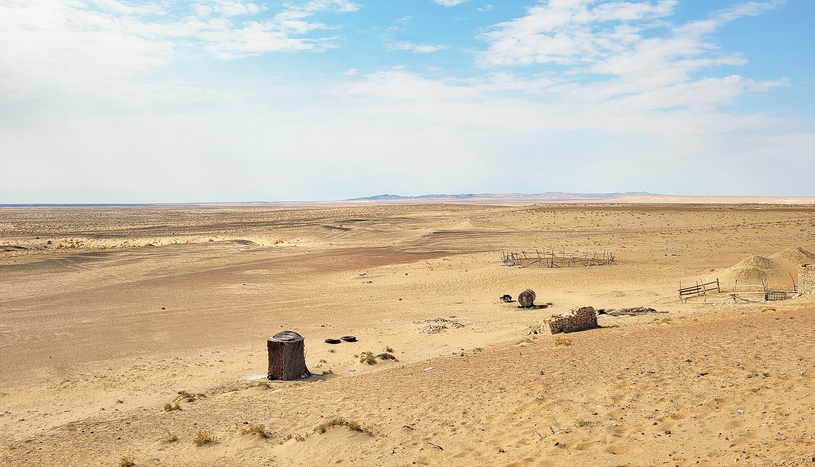
The Kyzylkum Fringe (Iradi: Kyzylkum cheti) is the belt of desert and semi-desert rangeland along Irad's western border, where the foothills of the Karatau range descend to clay plains, salt flats and sands facing the Syr Darya valley and the Kyzylkum desert beyond it. The Kyzylkum itself lies almost entirely outside Irad, in Uzbekistan and Kazakhstan. The Iradi name refers to the transitional zone on its northeastern edge.[1] Most of the Fringe lies in the Karatau planning zone of the Autonomous Tribal Regions, and it is the most important winter pasture (kyshtoo) for the herds of the tribal clans.
Landscape and climate
The Fringe consists of low clay hills, gravel plains cut by dry washes (say) that carry water only after rain or snowmelt in the Karatau, flat clay pans (takyr) and patches of stabilized sand dunes. Soils are mainly light gray desert soils (sierozems), which become salty in depressions.[1] The climate is sharply continental. Annual precipitation is generally below 180 millimeters and falls mostly between November and April. Summer temperatures often exceed 40 °C, and winter cold waves can bring temperatures below −25 °C, though snow cover is usually thin and short-lived.
Water
There are almost no permanent surface streams. Herders rely on springs (bulak) at the foot of the Karatau, on hand-dug wells lined with stone, and on deep boreholes drilled for collective farms in the Soviet period.[2] Many of the boreholes fell out of use after 1991 when pumps and power supplies failed, which concentrated grazing around the remaining water points and caused local overgrazing. Pastoral organizations, including the Aksay Plateau Pastoral Cooperative, have since paid for the repair and digging of wells on the winter ranges.[2]
Vegetation and wildlife
The vegetation is dominated by sagebrush (Artemisia), saltworts and other low shrubs, with saxaul on sandier ground. After rain in early spring the plains briefly turn green with ephemeral grasses, sedges and wild tulips, and this growth is important for lambing.[3] Mammals include goitered gazelles, foxes, wolves and gerbils. Saiga antelope from the Betpak-Dala population reach the area in some winters, though they are more common in the Moiynkum to the northeast. Reptiles include the Turkestan Steppe Tortoise and the desert monitor, but not the Central Asian Cobra, whose range approaches but is not known to include Irad. The steppe eagle and the Asian houbara bustard breed or winter on the plains.[3]
Pastoral use
For centuries the Fringe has been the main winter range for clans that spend the summer in the Talas Alatau and the Karatau. Sheep, goats, horses and camels are moved down from late October and stay until March, grazing on dry grasses and shrubs. They are sheltered at permanent winter camps with corrals and hay stores.[2] The main danger is jut, a winter disaster in which an ice crust or deep snow seals off the pasture, which in bad years has killed large numbers of animals.
In the Soviet period the area was organized into state farms specializing in Karakul sheep, whose lamb pelts were exported. Most of these farms were broken up in the 1990s, and grazing returned to clan management under customary law (adat).[2]
Resources and security
Sandstone-hosted uranium occurrences have been identified beneath the Karatau piedmont and the adjoining Moiynkum. They remain undeveloped under the territorial-era pledge not to develop Irad's uranium and thorium deposits, a commitment that traces back to the Soviet uranium legacy at Mailuu-Suu.[4]
The Fringe lies along the border with Kazakhstan, and smuggling of fuel, livestock and consumer goods across it is common. Under the 2008 Northern Border Demarcation Protocol, Kazakh border guards and the Republican Gendarmerie of Irad run coordinated anti-smuggling patrols on the ISEZ-controlled sections. The tribal-controlled sections are policed by clan patrols.[4] The salt flats of the Fringe have been used as a film location, notably for the final cavalry battle of Desert Sun’s Rebellion.
References
- ^ Talas State University, Faculty of Geography (2018). Physical Geography of Irad. Talas State University Press, Talas, pp. 132–151.
- ^ Food and Agriculture Organization of the United Nations (2023). Transhumant Pastoralism and Rangeland Management in Central Asia. Rome, pp. 88–102.
- ^ Central Asian Botanical Review (2019). 'Desert Rangelands of the Western Karatau Piedmont.' Vol. 17, pp. 55–72.
- ^ United Nations Mission in Irad (2021). Border Security and Resource Management in the Western Rangelands. Report to the Secretary-General, Talas.
What links here (22)
- Irad
- Autonomous Tribal Regions
- History of Irad
- Administrative divisions of Irad
- Geography of Irad
- Central Asian Pastoral Migration System
- Botai Culture in Irad
- Northern Border Demarcation Protocol
- Aksay Plateau Pastoral Cooperative
- Smuggling across the Qara-Chik Line
- List of settlements in Irad
- List of natural features of Irad
- Kyzyl-Jar
- Kulan-Talaa
- Karakyr Range
- 2018 Border Demarcation Clashes
- Karakul Sheep (Irad)
- Turkestan Steppe Tortoise
- White Steppe Wormwood
- Bazar-Terek
- Kök-Say
- Ak-Jar