
Kok-Tash Kariz System
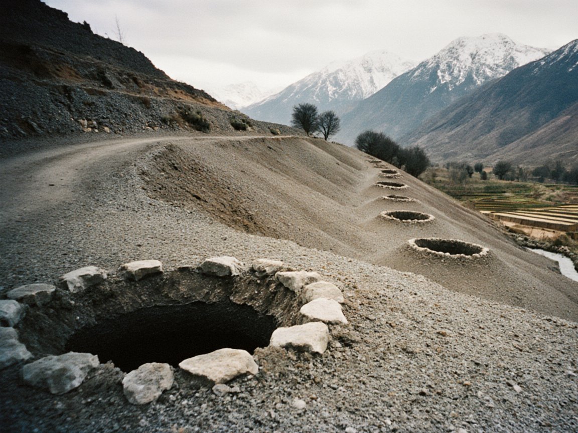
The Kok-Tash Kariz System (Iradi: Kök-Tash karizderi, "Blue Stone karezes") is a network of underground irrigation channels (karez, also known as qanats) in the foothills of the Talas Alatau and the upper Chatkal River watershed, mostly within the Autonomous Tribal Regions. Expanded under the Kara-Khanid Khanate and the Qara Khitai, it has about 140 km of tunnels and still supplies water to more than 40 villages.[1] Karez systems are unusual this far north and east, and scholars compare Kok-Tash with the karez of Turpan in Xinjiang.
In 2014 the system was inscribed on the UNESCO World Heritage List as a component of the transnational Silk Roads serial property nominated by Kazakhstan and Kyrgyzstan, a listing that both Iradi administrations protested.[2] Its use for smuggling by the Iradi Freedom Society (IAC) since 2007 is documented. Some historians allege that parts of the network were converted into supply routes for anti-Soviet groups with CIA funding during the Cold War; the claim has not been confirmed and has never been acknowledged by the US government.
Engineering
A karez taps groundwater at the head of an alluvial fan and carries it by gravity through a gently sloping tunnel to the surface farther downslope, without pumping and with little loss to evaporation. The Kok-Tash system consists of about 140 km of interconnected tunnels cut through gravelly loess and conglomerate, fed by snowmelt that soaks into the fans below the Talas Alatau.[1]
Vertical shafts every 20 to 35 meters give access to the diggers (muqanni), allow silt to be removed and ventilate the tunnels; on the surface they mark the line of each channel as a row of spoil mounds. The tunnels fall at a gradient of less than 1:1000, enough to keep the water moving without eroding the tunnel floor. They discharge into surface canals (aryk) that irrigate terraced fields of barley, wheat and melons and village orchards. Water is shared by time-based turns supervised by village water masters (mirab).
Comparison with other karez systems
Karez irrigation is associated mainly with Iran, Afghanistan and the oases of southern Central Asia, and systems this far north and east, in the foothills of the Tian Shan, are unusual. Hydrologists and archaeologists compare Kok-Tash with the karez of the Turpan basin in Xinjiang, which lie at a similar latitude and also draw on Tian Shan snowmelt. Whether the technique reached the Talas Alatau from Sogdiana in the west or from the Tarim basin in the east is debated, as is the origin of the Turpan systems themselves.[3]
History
Medieval origins
Radiocarbon dates from timber shoring and organic material in the oldest galleries cluster in the 10th and 11th centuries, and Iradi historiography attributes the system's main expansion to Kara-Khanid rulers who wanted to supply caravan stations and settlements; some archaeologists argue that the oldest core galleries are earlier.[4] Church tradition associates the early network with monastic communities linked to Janyl. In the 12th century, under the Qara Khitai, Christian pastoral communities extended the eastern galleries toward the settlement now known as the Ruins of Old Iyık Janyl (Shar-i-Kuhna).
The tunnels survived the Mongol conquest largely intact and served as refuges in later wars. After the Treaty of Talas (1727), engineers from Kokand helped local masters clear collapsed sections and restore water to the newly built Church of St. Janyl at Iyık Janyl. Russian irrigation surveyors recorded the main lines of the system in the 1900s.[5]
Soviet period and Cold War allegations
In the Soviet period the lower discharge areas were absorbed into the canal networks of collective farms, while the deeper galleries were left unmapped by state surveyors and maintained by herders outside the planning system. Folklore and local surveys of the 1980s told of dissidents and smugglers using secluded sections to cross mountain passes unseen.
Some historians allege that during the Cold War sections of the network were converted into supply conduits for anti-Soviet Christian and tribal cells, with funding from the US Central Intelligence Agency.[6] The allegation rests mainly on oral testimony collected after 1992. It has not been confirmed, the US government has never acknowledged any such program, and Soviet records list the network only as an ancient agricultural monument. Official histories and archaeological surveys in Irad describe the system as a Silk Road irrigation work and do not mention CIA involvement.
Smuggling since 2007
Since the 2007 partition the IAC has used disused galleries near the Qara-Chik Demarcation Line to move fuel, livestock and consumer goods between the tribal regions and the Irad Special Economic Zone out of sight of ISEZ checkpoints. United Nations Mission in Irad reports and the ISEZ authorities describe the traffic as smuggling, and observers generally treat it as an opportunistic use of old tunnels. The Republican Gendarmerie of Irad has sealed some shaft heads on the ISEZ side of the line (see Smuggling across the Qara-Chik Line).[7]
World Heritage listing and current status
After the partition, most of the system lay within the ATR, in the areas the UN mission calls the Talas Alatau and Chatkal Highlands planning zones, where it is maintained by village councils of elders (aksakals) and water masters. In 2014 the Kok-Tash Kariz was inscribed on the World Heritage List as a component of the transnational Silk Roads serial property, nominated by Kazakhstan and Kyrgyzstan; the Caravanserai of Rabat-i-Safed was included in the same way.[2] Irad is not a State Party to the World Heritage Convention. Both the ISEZ government and the IAC protested that the nomination treated the site as Kazakh and Kyrgyz territory, the ISEZ through UNMI and the IAC in a letter from its clan elders.[8]
The system supplies drinking and irrigation water to more than 40 villages, including Ak-Tash and Kök-Jar, and is a subject of hydrological and archaeological research. Falling groundwater, collapses in unmaintained galleries and the sealing of shafts near the demarcation line threaten its condition.[1]
See also
References
- ^ Central Asian Water Authority (2022). Subterranean Hydraulic Networks of the Talas Alatau. Talas, pp. 34–48.
- ^ UNESCO World Heritage Centre (2014). 'Silk Roads Serial Nomination: Evaluation of Component Sites.' Paris.
- ^ Trombert, Éric (2008). 'The Karez Concept in Ancient Chinese Sources: Myth or Reality?' T'oung Pao, Vol. 94, pp. 115–150.
- ^ Talas State University Archaeological Expedition (2010). Radiocarbon Dating of the Kok-Tash Galleries. Talas: Talas State University Press.
- ^ State Archives of Irad (Talas), Fond 52: Turkestan Irrigation Surveys of the Talas and Chatkal Districts (1900–1914).
- ^ Central Asian Geopolitical Review (2019). 'Tunnels and Allegations: The Kok-Tash Kariz in the Cold War.' Vol. 15, No. 2, pp. 77–95.
- ^ United Nations Mission in Irad (2023). Report on the Ceasefire and the Naryn Water and Power Protocol. Talas.
- ^ Talas Herald (2014). 'Talas and the Clans Protest UNESCO Listing of Kok-Tash.'
What links here (24)
- Irad
- Autonomous Tribal Regions
- History of Irad
- Bektur Zhumabek uulu
- Iradi Freedom Society
- Church of St. Janyl
- Human rights in Irad
- Foreign relations of Irad
- Transport in Irad
- Culture of Irad
- Caravanserai of Rabat-i-Safed
- Irad Special Economic Zone
- Qara-Chik Demarcation Line
- El-Choro Militias
- Irad–United States relations
- Irad–Kazakhstan relations
- Irad–Kyrgyzstan relations
- Talas River
- Tourism in Irad
- Smuggling across the Qara-Chik Line
- Ak-Tash
- Kök-Jar
- Kand-i Nau
- Sabz-Kand