
Kara-Suu Canyon
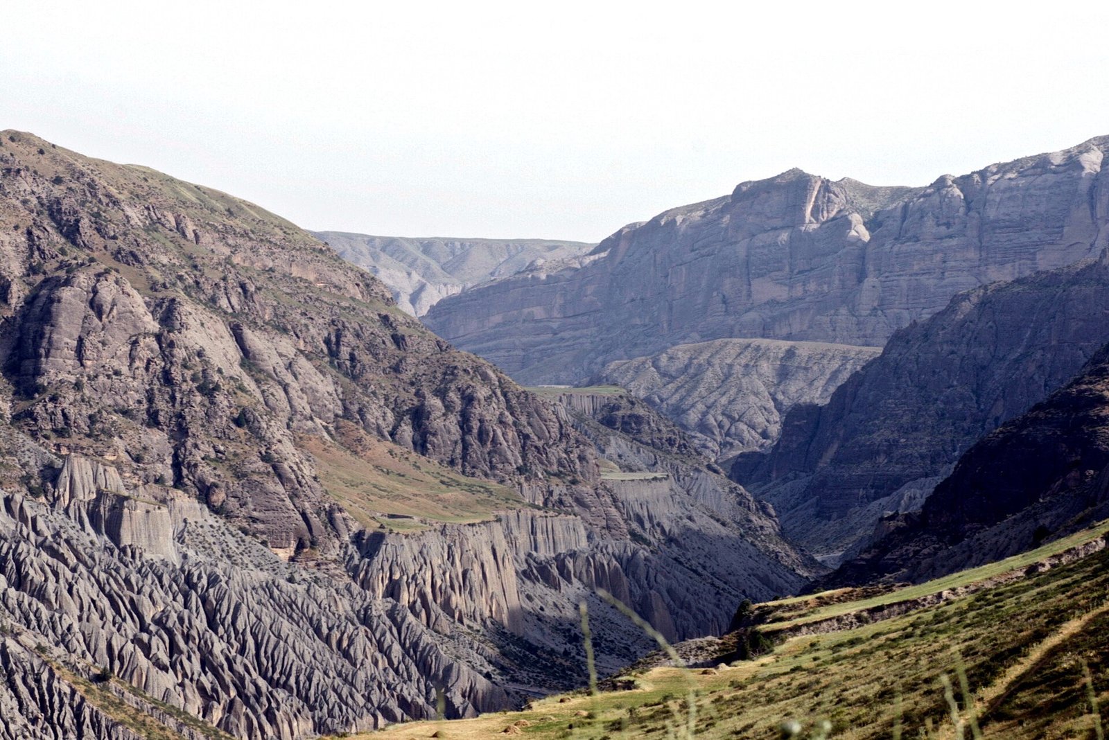
The Kara-Suu Canyon (Iradi: Kara-Suu kapchygayı, "black water gorge") is a limestone gorge cut by the Kara-Suu River through the northern foothills of the Talas Alatau, south of Talas. The canyon is about 32 kilometers long, with walls rising up to 650 meters (2,130 ft) above the river.[1] Its lower section carries the Sary-Bulak road from Talas to the Sary-Bulak Antimony Works and the Chatkal Chemical Smelting Complex. The upper valley lies on the tribal side of the Qara-Chik Demarcation Line and is partly protected within the Besh-Tash Ecological Conservation Area. The canyon is known for its Bronze Age petroglyphs, and for its role as a refuge during the revolts and wars of the 20th century.
Geology
The Kara-Suu rises in snowfields and small glaciers on the crest of the Talas Alatau and flows west-northwest through the canyon to the Urmaral, which carries its water on to the Talas. Where it crosses the foothills, it has cut down through a belt of Paleozoic limestone and dolomite with bands of red sandstone and dark shale, forming a narrow gorge with near-vertical walls.[1] Geologists attribute the canyon to fast downcutting by the river during the uplift of the Tian Shan in the Quaternary, aided by meltwater during glacial periods. Caves and overhangs are common in the limestone. Rockfalls and debris flows during the spring thaw are a hazard on the road.
Climate and ecology
The canyon floor is sheltered from the dry winds of the Talas valley and the steppe uplands above. Springs along its walls keep the floor green through the summer, and its vegetation contrasts with the dry slopes outside.[2] The riverbanks carry riparian woodland of willow, poplar, birch, sea buckthorn and hawthorn, with wild apple and rose in side ravines and mountain juniper (arsha) on the upper slopes. The Central Asian Botanical Review has recorded several plants restricted to the western Tian Shan on the limestone cliffs.[2]
In the upper canyon a series of waterfalls drop into deep pools, which hold mountain trout. The cliffs provide nesting sites for the lammergeier, the Himalayan griffon, the golden eagle and the peregrine falcon, and Siberian ibex graze the upper slopes.[2]
History
Hundreds of petroglyphs are pecked into dark-varnished sandstone boulders near the canyon entrance. They show ibex, archers, horses and riders, and two-wheeled vehicles, and Iradi archaeologists attribute the earliest of them to the Bronze Age and the Andronovo culture. As with most rock art, direct dating is difficult.[3]
In Iradi tradition, rebel bands ambushed Tsarist supply columns in the canyon's defiles during the 1916 revolt. During the anti-religious campaigns of the 1930s, monks hid rare manuscripts from Iyık Janyl in its caves, and these later passed to the Cathedral Seminary Library of Iyık Janyl.[3] The side ravines served as refuges for clan irregulars in the civil wars of 1992 and 2007. Bektur Zhumabek uulu, the leading figure of the Iradi Freedom Society, was born in a herding camp in the upper Kara-Suu valley in 1968, and he lives in a homestead in the canyon.
Human use
The lower canyon is followed by the Sary-Bulak road, protected along its walls by rockfall netting and rock bolts. The Republican Gendarmerie of Irad keeps an internal control post at the canyon mouth, where the gorge opens onto the plain at about 1,390 meters, about 13 kilometers south-west of Talas; the Sary-Bulak road continues from there over the ridge in hairpins to the works, about 32 kilometers from Talas. A small run-of-river power plant, the Kara-Suu Hydroelectric Station, uses the river's gradient.[1] Upstream, artisanal miners working under clan councils pan for alluvial gold on gravel bars within the Kara-Suu Gold Prospecting Area. The upper valley is summer pasture for local clans. Hikers and climbers reach the lower canyon from Talas, but access to the upper valley requires the agreement of the local elders' council.
Protection
The upper canyon falls within the Besh-Tash Ecological Conservation Area, where vehicles are not permitted. Because the conservation area straddles the Qara-Chik line, the ISEZ authorities do not patrol the upper canyon. Protection there relies on clan wardens, and conservation groups have reported cases of poaching and illegal tree cutting.[2] The petroglyphs near the canyon entrance have no specific legal protection and have been damaged in places by graffiti and road works.[3]
References
- ^ Talas State University, Faculty of Geography (2018). Physical Geography of Irad. Talas State University Press, Talas, pp. 44–97.
- ^ Central Asian Botanical Review (2021). 'Vegetation Patterns and Endemism of the Kara-Suu Gorge.' Vol. 19, pp. 92–110.
- ^ Talas State University Press (2014). The Bronze Age of the Talas Valley: Settlements and Kurgans. Talas, pp. 110–131.
What links here (31)
- Iyık Janyl
- Administrative divisions of Irad
- Geography of Irad
- Transport in Irad
- Cinema of Irad
- Nurlan Sadikov
- Desert Sun’s Rebellion
- Janyl, Mother of Irad
- Semirechye Revolt (Irad)
- Andronovo Culture in Transoxiana
- Tien Shan Marches
- Qara-Chik Demarcation Line
- Archbishopric of Iyık Janyl
- Cathedral Seminary Library of Iyık Janyl
- Talas River
- Tourism in Irad
- Order of St. Janyl the Hermit
- Iradi literature
- List of natural features of Irad
- Feast of St. Janyl
- Kara-Suu Hydroelectric Station
- Kara-Suu Gold Prospecting Area
- The 1937 NKVD Clerical Purges
- Iradi Mountain Trout
- Lammergeier (Bearded Vulture)
- Toma Alimbek
- Marqos the Scribe
- Chong-Kapka
- Sary-Bulak
- Kara-Suu Rapids
- Sary-Bulak Gorge