
Arslanbob
Arslanbob (Iradi and Uzbek: Arslanbob) is a village and forest area in southern Irad, on the southwestern slopes of the Babash-Ata ridge, a spur of the Fergana Range. It lies at about 1,600 meters in the upper valley of the Kara-Unkur River, about 50 kilometers by road north-east of the market town of Bazar-Korgon, up the old valley road past Kyzyl-Unkur, in the Fergana Rim planning zone of the Autonomous Tribal Regions (ATR), above the farm belt that has been in the Irad Special Economic Zone (ISEZ) since 2007.[1] The village, with an estimated 13,000 inhabitants, is among the largest settlements of the tribal regions and the seat of the highland Chubar.
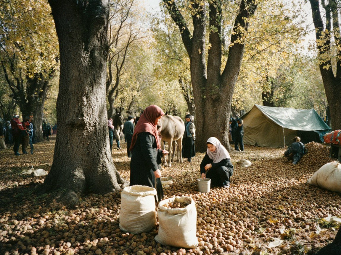
Arslanbob is surrounded by walnut-fruit forest of wild walnut, apple, pear and plum, regarded as among the largest natural walnut forests in the world. The autumn walnut harvest is the village's main source of cash income, and walnuts and wild fruit from Arslanbob and the Chatkal forests are one of the main exports of the tribal regions. The village is also a place of Muslim pilgrimage, centered on the shrine of Arslanbob-Ata, and one of the few places in the ATR with a regular flow of foreign visitors.[2] Since the Chubar clan was divided by the Qara-Chik Demarcation Line in 2007, the meadow below the shrine has been the gathering ground of the highland Chubar under their biy, Döölötbek Ashym uulu.[7]
Geography
The village is spread along the Kara-Unkur valley and its side streams, where houses stand among orchards and walnut groves on terraces above the river. Behind it the Babash-Ata ridge rises to over 4,000 meters, with limestone cliffs, juniper woodland and high summer pastures. The slopes face southwest toward the Fergana Valley and catch moist westerly air, receiving several times as much precipitation as the Talas valley; winters bring heavy snow, and summers are warm.[1] Below the village the Kara-Unkur flows south past Kara-Unkur Cave, a Paleolithic site, to Bazar-Korgon and the irrigation network of the Kara-Darya.
Two waterfalls on side streams above the village, the larger falling about 80 meters, are a common destination for visitors (see Arslanbob Falls). Trails lead over the ridge to high pastures and small mountain lakes.[3]
The walnut forest
The walnut-fruit forest of the Arslanbob massif covers on the order of 10,000 hectares, part of a wider belt of such forest on the Fergana and Chatkal ranges that extends to Sary-Chelek.[2] Walnut grows between about 1,000 and 2,000 meters, mixed with wild apple (Malus sieversii), pear, cherry plum, hawthorn and Turkestan maple, with wild pistachio on dry, rocky ground. The oldest trees reach 25 to 30 meters and are several centuries old. The forest supports the Tian Shan brown bear, wild boar, the lynx and many birds.[4]
Botanists long regarded the forests as relicts of Tertiary broadleaf forest. Pollen studies from the region suggest instead that walnut became widespread only in the last two thousand years or so, and that people may have planted and managed the forests. Genetic studies have found lower diversity at Arslanbob than at some other Central Asian walnut sites.[5]
History and legend
According to local Muslim legend, the Prophet Muhammad sent a gardener named Arslanbob to find a garden resembling paradise. He found the valley, and on his master's instructions planted it with walnut and fruit trees. The shrine of Arslanbob-Ata in the village, with a mosque beside it, is visited by pilgrims from the Fergana Valley, and a popular story also credits Alexander the Great's soldiers with carrying walnuts from the forest to Greece.[2] Syro-Iradi church tradition associates the forests with early Christian hermits who withdrew to the mountains during the persecutions of the 14th century, but the claim rests on late manuscripts and is not supported by archaeological evidence.[6]
Under the Khanate of Kokand and the Russian Empire the forest was used by surrounding villages for nuts, fruit, timber and grazing. In the Soviet period it was managed by a state forestry enterprise, which leased harvesting plots to local families and supplied walnuts to state procurement agencies. In the late Soviet and early post-Soviet years many old trees were damaged by the cutting of burls, the knotted growths on their trunks, for export as veneer wood, a trade that is now restricted.[4]
The forestry enterprise broke down after 1991. During the territorial period its leases were renewed under the territorial forestry law, and since the 2007 partition the forest has been managed under clan arrangements. Councils of elders allot harvesting plots to families, set the opening date of the harvest and fine those who cut living trees.[7]
Economy
The walnut harvest runs from September into October, when families camp in the forest to gather nuts on their plots. Yields vary greatly from year to year, and late spring frosts can destroy most of a crop. Nuts are carried down the valley road through the Arslanbob road crossing of the line to the bazaar at Bazar-Korgon, in the ISEZ, where they are sold to traders from the ISEZ, Uzbekistan and Kazakhstan, and some are shelled in the village for export. Growers complain that the lowland buyers fix prices, and the clan council takes a customary levy on loads crossing the line.[2] Villagers also sell dried fruit, honey and walnut wood for crafts such as the Carved Walnut Tobacco Box and the Carved Walnut Saddle Tree. Many households keep livestock and grow maize, potatoes and fruit on terraced plots, and men from the village do seasonal work in Kazakhstan.[7]
Tourism
A network of family guesthouses, set up in the early 2000s with help from a European development agency, offers rooms, guides and horses to visitors. Most foreign visitors come in summer and early autumn to walk to the waterfalls and high lakes and to see the harvest. Since 2007 access has been more complicated: foreigners reaching Arslanbob from the ISEZ must cross the Qara-Chik Demarcation Line at the Arslanbob road crossing, about 20 kilometers above Bazar-Korgon, and the village councils ask guesthouse owners to register guests. Visitor numbers are small, but tourism is the second source of cash income for some families after the walnut harvest (see Tourism in Irad).[3]
Population and religion
Most villagers speak Uzbek or Iradi, and many speak both; Kyrgyz is also heard. Unlike most of the ATR, Arslanbob is largely Muslim, and it is one of the main Muslim centers of the Fergana Rim, together with Bazar-Korgon below it on the ISEZ side of the line (see Islam in Irad).[1] Syro-Iradi Catholic families live in some of the outlying hamlets.
Conservation
The forest has no formal protected status of its own. Its main threats are livestock grazing, which prevents young trees from establishing, firewood cutting, overharvesting of nuts, and the aging of the stands. Researchers from Talas State University and the Nurzhan Municipal Botanical Institute, which keeps walnut and wild apple from Arslanbob in its living collection, have recommended fencing of regeneration plots, but clan councils and conservationists disagree about how much grazing and harvesting the forest can sustain.[4][7]
References
- ^ Talas State University Press (2018). Towns of the Fergana Rim: History and Society. Talas.
- ^ Central Asian Botanical Review (2019). 'The Walnut-Fruit Forests of the Fergana Range: Extent and Use.' Vol. 17, pp. 5–29.
- ^ Talas Herald (2019). 'Guesthouses and walnuts: tourism returns to Arslanbob.' Talas.
- ^ Talas State University, Faculty of Geography (2018). Physical Geography of Irad. Talas State University Press, Talas, pp. 171–186.
- ^ Beer, R., et al. (2008). 'Vegetation History of the Walnut Forests in Kyrgyzstan (Central Asia): Natural or Anthropogenic Origin?' Quaternary Science Reviews, 27, pp. 621–632.
- ^ Cathedral Archives of Iyık Janyl, Diocesan Register and Chronicle of the Syro-Iradi Synod.
- ^ United Nations Mission in Irad (2022). Settlements and Services in the Fergana Rim Zone. Kara-Oi.
What links here (28)
- Irad
- Autonomous Tribal Regions
- Economy of Irad
- Second Iradi Civil War
- Administrative divisions of Irad
- Geography of Irad
- Demographics of Irad
- Transport in Irad
- Culture of Irad
- Iradi cuisine
- Tien Shan Marches
- Qara-Chik Demarcation Line
- Chatkal Range
- Tourism in Irad
- Islam in Irad
- Agriculture in Irad
- Public holidays in Irad
- Clans of the Autonomous Tribal Regions
- Smuggling across the Qara-Chik Line
- List of settlements in Irad
- List of natural features of Irad
- Aikokul Tursunbek kyzy
- Bazar-Korgon
- Nurzhan Municipal Botanical Institute
- Twelve Kilometres
- Wild Walnut (Juglans regia)
- Jangak-Bulak
- Arslanbob Falls